Land Management Search Results
Resource
Authors
Alberta Biodiversity Monitoring Institute
As of 2010, human footprint in the Active In-situ Region was 7.7%, whereas it was 20.8% in the Mineable Region. Total human footprint in all Woodland Caribou ranges increased between 2007 and 2010
Resource
Authors
Alberta Biodiversity Monitoring Institute
As of 2012, the total human footprint across the OSR was 13.8%. Energy footprint covered 2.2% of the OSR. The total human footprint in the OSR increased from 11.3% to 13.8% between 1999 and 2012.
Resource
Authors
Alberta Biodiversity Monitoring Institute
This report presents data on several indicators of environmental health for the Kakwa River Project area where ARC Resources operates in northwestern Alberta. The Kakwa River Project area covers...
Resource
Oil and gas activities in Alberta require disturbing forested lands, among other ecosystems, in order to extract resources. Due to the number of oil and gas sites requiring reclamation, monitoring can...
Resource
Authors
Amy Nixon
Christopher Shank
Dan Farr
The Biodiversity Management and Climate Change Adaptation project has produced a comprehensive, evidence-based, and original examination of the effects of climate change on Alberta’s biodiversity
Resource
Authors
Jennifer Hird
Alessandro Montaghi
Gregory McDermid
Jahan Kariyeva
Brian Moorman
Scott Nielsen
Anne McIntosh
Good statistical agreement between key structural vegetation parameters, such as mean and maximum vegetation height, with PPC metrics successfully predicting most height and tree-diameter metrics.
Resource
Authors
William Wadsworth
Ave Dersch
Robin Woywitka
Kisha Supernant
The Athabasca Oil Sands (AOS) region of Alberta has one of the densest accumulations of known archaeological sites, and possibly the most archaeological sites at risk, in the country. Expanding...
Resource
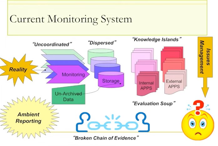
Jim Schieck, research scientist at Alberta Innovates – Technology Futures, discusses how cumulative effects are currently being assessed in Alberta. He talks about the pilot study of how to use...
Resource
Video tutorial that lays out the field sampling process for reclaimed wetland assessment from start to finish in easy-to-follow steps and visually clarifies how protocols should be enacted
Resource
Authors
Aseniwuche Winewak Nation
A brief video outlining what the Caribou Patrol Program does, who we are and how we came to be.
Resource
ABMI is working with the Government of Alberta to develop new methods to estimate caribou numbers, a species that is notoriously hard to count because of their rarity and association with dense forest
Resource
Authors
Shannon White
Jim Herbers
Jasmine Janes
Sarah Depoe
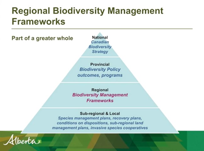
Shannon R. White is the Biodiversity Specialist for the Land-use Framework Regional Planning Branch for ESRD. She discusses Biodiversity Management Frameworks (BMFs), including indicators, triggers...
Resource
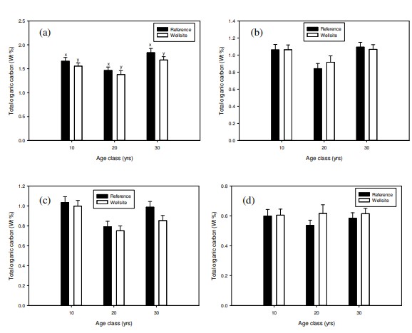
I will introduce ABMI’s Ecological Recovery Monitoring program, which is establishing long-term monitoring protocols to assess ecological recovery at certified reclaimed wellsites across Alberta
Resource
Presentation tracks the evolution in technology used to monitor birds by recording their songs, with examples from different regions of the province.
Resource
Ernie Hui gave a keynote address at the CWRA-WPAC joint conference on March 13, 2013. Ernie Hui is the CEO, Environmental Monitoring, for Alberta Environment and Sustainable Resource Development. The...
Resource
Monitoring and conservation of rare species, particularly in the boreal forests of northern Alberta, is a challenge due to knowledge gaps on distribution and abundance of species
Resource
On 19th June 2023, BirdWatch Ireland hosted an online presentation by Dr. Flo Renou Wilson, peatland expert from University College Dublin. Participants included members of different organisations...
Resource
Jason Fisher is the Senior Research Scientist in Wildlife Ecology for Alberta Innovates and his presentation is about White-tailed deer in boreal Alberta. White-tailed deer are expanding their...
Resource
Authors
Axel Anderson
Richard Mccleary
Sheena Spencer
Michael Wagner
Resource Date:
January
2018
This poster outlines the development of a watershed assessment procedure for the eastern slopes of Alberta. The process was developed with the Oldman Watershed Council, using the Oldman River Basin as a study site.
Resource
There is uncertainty related to the long-term consequences of reconstructing landscapes on Alberta’s specified lands. Alberta has over 100,000 wellsites that have been certified under evolving...