Land Management Search Results
Resource
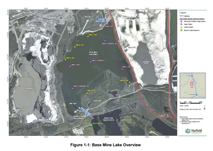
Syncrude's Base Mine Lake (BML) is the first, and currently the only full-scale commercial demonstration of the end pit lake technology in the oil sands industry. An oil sands end pit lake (EPL) is an...
Resource
Authors
Daphne Cheel
Stephen Moran
Mark Trudell
Don Thacker
Terry Macyk
Report synthesizes and summarizes 36 RRTAC reports to provide the user with a unified source of information on land and groundwater reclamation research in the plains of Alberta
Resource
Authors
Leila Taheriazad
Carlos Portillo-Quintero
Arturo Sanchez-Azofeifa
This report presents a comprehensive review of industrial applications of an emerging environmental monitoring technology called Wireless Sensor Networks (WSN) and a WSN installed at Coal Valley Mine
Resource
Pilot study to assess the use of early successional stands (i.e. those ranging in age from 4 to 17 years) by wildlife (songbirds, small mammals, and ungulates), using a wildlife monitoring protocol
Resource
Authors
Roger DeAbreu
Shane Patterson
Todd Shipman
Chris Powter
NRCan pilot science projects have proven that Earth Observation can provide relevant and valuable information to inform and enhance monitoring and support regulatory frameworks
Resource
Authors
Ken Foster
Christine Godwin
Peter Pyle
The MAPS protocol (Monitoring Avian Productivity and Survivorship) was applied in a 2011 pilot program in the boreal forest in the oil sands region
Resource
Authors
Nadia Rochdi
J. Zhang
Karl Staenz
X. Yang
D. Rolfson
J. Banting
C. King
R. Doherty
Scope of the project is to develop a geomatics-based monitoring system to support the Government of Alberta’s efforts for monitoring reclamation success. Software will support decision making process
Resource
In most years, evaporation exceeds summer rainfall. Using natural aspen stands as a comparison, it is expected that water use from the soil cover will continue to increase as the ecosystem ages.
Resource
Authors
Richard Johnson
P. Bork
E.A.D. Allen
W.H. James
L. Koverny
The experiments detailed in this report show that it was possible to increase the solids content of sludge to 50% solids by adding three parts sand (tailings sand) to one part sludge.
Resource
Authors
Stephen Moran
Terry Macyk
Mark Trudell
Margot Pigot
In 1985, a one hectare pond developed in the upland reclaimed landscape at Vesta Mine in an area where extensive ponding had not previously been observed. Because of the thickness of the spoil, about...
Resource
Authors
Stephen Moran
Mark Trudell
Terry Macyk
Daphne Cheel
The first phase of the study, which was completed in 1984, included characterization and instrumentation of two study areas: the Battle River study area, which included Diplomat, Vesta and Paintearth...
Resource
Authors
Virgil Hawkes
Gillian Donald
A long-term plot network would allow the monitoring data to describe the ecological condition of the reclaimed lands and define appropriate management strategies for achieving revegetation goals
Resource
Authors
Terry Macyk
Martin Fung
Ron Pauls
Syncrude Canada Ltd. produces 200,000 barrels of synthetic crude oil per day from its oil sands surface mining operations located 50 km north of Fort McMurray, Alberta. The three major types of...
Resource
Authors
Mar Martinez
Gary Borstad
Leslie Brown
Kaan Ersahin
Michael Henley
Monitoring of reclaimed sites is a complex, interdisciplinary undertaking, especially in large, disturbed areas with difficult access. In that context, remote sensing is a unique and valuable tool...
Resource
Video tutorial that lays out the field sampling process for reclaimed wetland assessment from start to finish in easy-to-follow steps and visually clarifies how protocols should be enacted