Land Management Search Results
Resource
Authors
Alberta Biodiversity Monitoring Institute
As of 2010, human footprint in the Active In-situ Region was 7.7%, whereas it was 20.8% in the Mineable Region. Total human footprint in all Woodland Caribou ranges increased between 2007 and 2010
Resource
Authors
Alberta Biodiversity Monitoring Institute
As of 2012, the total human footprint across the OSR was 13.8%. Energy footprint covered 2.2% of the OSR. The total human footprint in the OSR increased from 11.3% to 13.8% between 1999 and 2012.
Resource
Authors
Alberta Biodiversity Monitoring Institute
This report presents data on several indicators of environmental health for the Kakwa River Project area where ARC Resources operates in northwestern Alberta. The Kakwa River Project area covers...
Resource
Authors
Karine Pigeon
Meghan Anderson
Doug MacNearney
Jerome Cranston
Gordon Stenhouse
Laura Finnegan
This resource is available on an external database and may require a paid subscription to access it. It is included on the CCLM to support our goal of capturing and sharing the breadth of all...
Resource
Oil and gas activities in Alberta require disturbing forested lands, among other ecosystems, in order to extract resources. Due to the number of oil and gas sites requiring reclamation, monitoring can...
Resource
Authors
Randi Lupardus
Ermias Azeria
Kierann Santala
Isabelle Aubin
Anne McIntosh
Results suggest that even as practices and policies evolve, reclamation does not fully alleviate the legacy effects of industrial disturbance. Trait-based approaches can inform recovery assessment.
Resource
Authors
Jennifer Hird
Alessandro Montaghi
Gregory McDermid
Jahan Kariyeva
Brian Moorman
Scott Nielsen
Anne McIntosh
Good statistical agreement between key structural vegetation parameters, such as mean and maximum vegetation height, with PPC metrics successfully predicting most height and tree-diameter metrics.
Resource
Authors
K.A. Baldwin
L. Allen
S. Basquill
K. Chapman
D. Downing
N. Flynn
W. Mackenzie
M. Major
W.J. Meades
D. Meidinger
C. Morneau
J.-P. Saucier
J. Thorpe
Vegetation Zones of Canada: a Biogeoclimatic Perspective maps Canadian geography in relation to regional climate, as indicated by vegetation patterns. Compared to previous similar national-scale...
Resource
The presentation covers the use of remote sensing in assessing biodiversity and how using covariate data can improve on the interpretation of results
Resource
Video tutorial that lays out the field sampling process for reclaimed wetland assessment from start to finish in easy-to-follow steps and visually clarifies how protocols should be enacted
Resource
The goal of the program is to develop a set of spatially explicit models that can be used to map the supply and economic value ecosystems goods and services
Resource
I will introduce ABMI’s Ecological Recovery Monitoring program, which is establishing long-term monitoring protocols to assess ecological recovery at certified reclaimed wellsites across Alberta
Resource
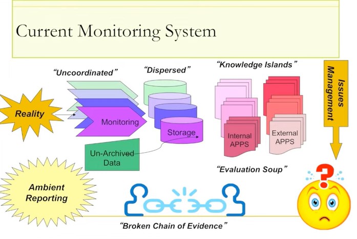
Ernie Hui gave a keynote address at the CWRA-WPAC joint conference on March 13, 2013. Ernie Hui is the CEO, Environmental Monitoring, for Alberta Environment and Sustainable Resource Development. The...
Resource
Monitoring and conservation of rare species, particularly in the boreal forests of northern Alberta, is a challenge due to knowledge gaps on distribution and abundance of species
Resource
There is uncertainty related to the long-term consequences of reconstructing landscapes on Alberta’s specified lands. Alberta has over 100,000 wellsites that have been certified under evolving...