Boreal Caribou Search Results
Resource
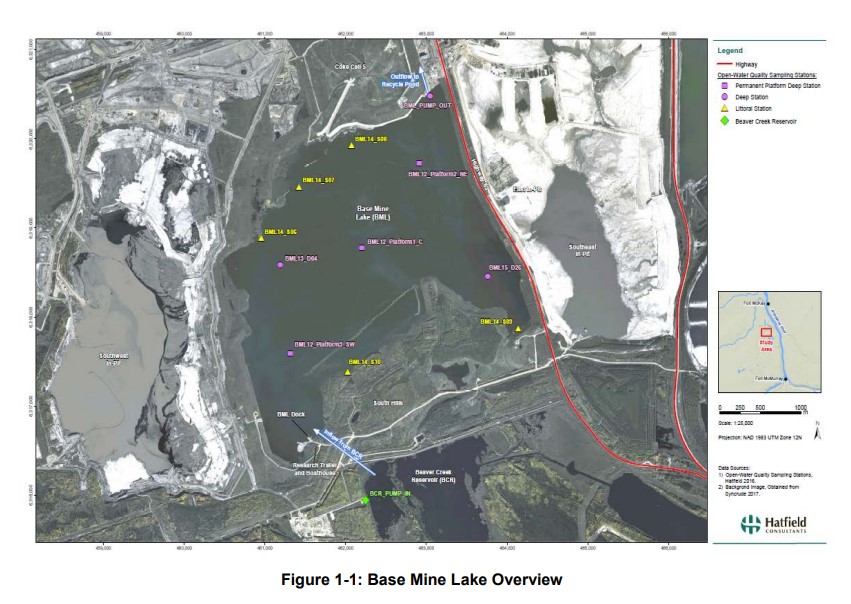
Syncrude's Base Mine Lake (BML) is the first, and currently the only full-scale commercial demonstration of the end pit lake technology in the oil sands industry. An oil sands end pit lake (EPL) is an...
Resource
Authors
Erin Bayne
Jacqueline Dennett
Jenet Dooley
Monica Kohler
Jeff Ball
Mark Bidwell
Andrew Braid
John Chetelat
Eric Dillegeard
Dan Farr
Jason Fisher
Maureen Freemark
Ken Foster
Christine Godwin
Craig Hebert
Dave Huggard
Dianne McIssac
Tara Narwani
Scott Nielsen
Bruce Pauli
Sanjay Prasad
David Roberts
Simon Slater
Samantha Song
Stella Swanson
Phil Thomas
Judith Toms
Colin Twitchell
Shannon White
Faye Wyatt
Lukas Mundy
One of the theme areas monitored within the OSM program is terrestrial biodiversity, known programmatically as Terrestrial Biological Monitoring (TBM). Biodiversity refers to the diversity of wild...
Resource
Authors
Sean Konkolics
Melanie Dickie
Robert Serrouya
Dave Hervieux
Stan Boutin
Resource Date:
August
2021
This resource is available on an external database and may require a paid subscription to access it. It is included on the CCLM to support our goal of capturing and sharing the breadth of all...
Resource
Authors
Alberta Biodiversity Monitoring Institute
As of 2015, 29.2% of Alberta is under human footprint, up from 25.7% in 1999—that’s an average increase of about 0.22%, or around 1450 km2 (560 sections) per year.
Resource
Authors
Joe Melton
Ed Chan
Koreen Millard
Matthew Fortier
Scott Winton
Javier Martín-López
Hinsby Cadillo-Quiroz
Darren Kidd
Louis Verchot
Peatlands play an integral role in the global carbon and hydrologic cycles and make up 3% of the Earth’s total landscape. Despite their importance, there is a lack of accurate information on the...
Resource
Authors
Mir Mustafizur Rahman
Gregory McDermid
Maria Strack
Julie Lovitt
Resource Date:
October
2017
Groundwater level (GWL) and depth to water (DTW) are related metrics aimed at characterizing groundwater-table positions in peatlands, and two of the most common variables collected by researchers...
Resource
Vegetation workshop was held November 1979 to evaluate user needs for more detailed vegetation descriptions and maps and to review the results of the vegetation survey as a step towards meeting needs
Resource
Authors
Erin Bayne
Diana Stralberg
Amy Nixon
Use of ABMI samples to understand genetic variation and changes in genetic structure is identified as an area where ABMI data can be used to understand how biodiversity is adapting to climate change
Resource
Authors
Natalie Shelby-James
Sarah Thacker
Chris Powter
Paul Fuellbrandt
Tomislav Hengl
Leandro Parente
Objective is to work collaboratively with soil data users to develop the Alberta Background Soil Quality System (ABSQS) as a tool to assist industry and government in environmental management
Resource
The Natural Regions and Subregions classification represents the state-of-the-art in ecological land classification in Alberta. This classification provides a valuable baseline for resource management...
Resource
Authors
Daniel MacIsaac
Graham Hillman
P.A. Hurdle
Since 1995, the Canadian Forest Service, Natural Resources Canada has conducted collaborative research with Tolko Industries Ltd. to study alternative silviculture systems as a means of improving...
Resource
Authors
R.B. Caton
C.S. Davis
Martin Davies
D.L.M. Stevens
Ron Wallace
Tony Yarranton
Reid Crowther
The result of this review was a plan for a five-year biophysical monitoring program to provide the necessary scientific and technical information upon which to base an effective regulatory approach.
Resource
Authors
Karine Pigeon
Megan Hornseth
Doug MacNearney
Laura Finnegan
We used GPS data from caribou and wolves, field data on human and wildlife use of seismic lines and pipelines, vegetation heights extracted from LiDAR, non-invasive fecal DNA collections, and a suite...
Resource
Authors
Cory Savage
Tanner Owca
Mitchell Kay
Jelle Faber
Brent Wolfe
Roland Hall
Potential for downstream delivery of contaminants via Athabasca River floodwaters to lakes of the PAD has raised local to international concern. Here, we quantify enrichment of eight metals (Be, Cd...
Resource
Authors
Leila Taheriazad
Carlos Portillo-Quintero
Arturo Sanchez-Azofeifa
This report presents a comprehensive review of industrial applications of an emerging environmental monitoring technology called Wireless Sensor Networks (WSN) and a WSN installed at Coal Valley Mine
Resource
Authors
Marcus Becker
Dave Huggard
Melanie Dickie
Camille Warbington
Jim Schieck
Emily Herdman
Robert Serrouya
Stan Boutin
Estimating animal abundance and density are fundamental goals of many wildlife monitoring programs. Camera trapping has become an increasingly popular tool to achieve these monitoring goals due to...
Resource
Several insect species and groups of insects are examined for their potential as biological indicators in the AOSERP area.
Resource
Authors
Aaron Sekerak
Gordon Walder
Maps showing fish collection locations, photos and details of the physical characteristics of nine streams within five watersheds (Firebag, Muskeg, Steepbank, MacKay, and Ells) in AOSERP study area
Resource
During 1978, a number of aquatic projects were funded by AOSERP using a habitat inventory and mapping approach.
Resource
Pesticide Chemicals Branch of Alberta Environment conducted a monitoring program in 1979 related to two methoxychlor treatments of the Athabasca River for black fly (Simulium arcticum) control.