Land Management Search Results
Resource
Authors
William Wadsworth
Ave Dersch
Robin Woywitka
Kisha Supernant
The Athabasca Oil Sands (AOS) region of Alberta has one of the densest accumulations of known archaeological sites, and possibly the most archaeological sites at risk, in the country. Expanding...
Resource
Authors
K.A. Baldwin
Lorna Allen
S. Basquill
K. Chapman
D. Downing
N. Flynn
W. Mackenzie
M. Major
W.J. Meades
D. Meidinger
C. Morneau
J.-P. Saucier
J. Thorpe
Vegetation Zones of Canada: a Biogeoclimatic Perspective maps Canadian geography in relation to regional climate, as indicated by vegetation patterns. Compared to previous similar national-scale...
Resource
The presentation covers the use of remote sensing in assessing biodiversity and how using covariate data can improve on the interpretation of results
Resource
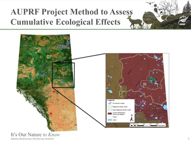
Jim Schieck, research scientist at Alberta Innovates – Technology Futures, discusses how cumulative effects are currently being assessed in Alberta. He talks about the pilot study of how to use...
Resource
Video tutorial that lays out the field sampling process for reclaimed wetland assessment from start to finish in easy-to-follow steps and visually clarifies how protocols should be enacted
Resource
Oil sands industry case study evaluated the economic and ecological performance of alternative offset networks targeting either ecologically equivalent areas or regional conservation priorities
Resource
I will demonstrate how data from ABMI can be combined with designed research studies to answer questions at spatial scales and temporal extents that are not possible for a single researcher to achieve
Resource
Authors
Shannon White
Jim Herbers
Jasmine Janes
Sarah Depoe
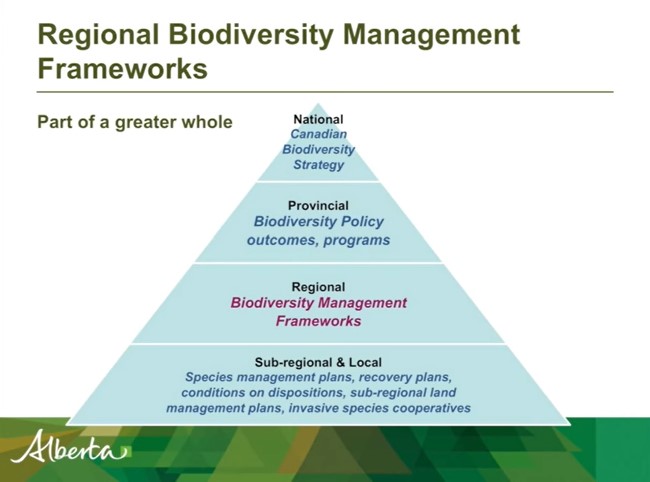
Shannon R. White is the Biodiversity Specialist for the Land-use Framework Regional Planning Branch for ESRD. She discusses Biodiversity Management Frameworks (BMFs), including indicators, triggers...
Resource
This presentation provides insight and understanding to how LiDAR data is used to produce digital elevation models and vegetation maps.
Resource
The goal of the program is to develop a set of spatially explicit models that can be used to map the supply and economic value ecosystems goods and services
Resource
I will introduce ABMI’s Ecological Recovery Monitoring program, which is establishing long-term monitoring protocols to assess ecological recovery at certified reclaimed wellsites across Alberta
Resource
The presentation describes how multi-temporal remote sensing offers a better understanding of landscape changes over time in comparison to the more traditional two-date, before and after comparison.
Resource
Presentation tracks the evolution in technology used to monitor birds by recording their songs, with examples from different regions of the province.
Resource
Ernie Hui gave a keynote address at the CWRA-WPAC joint conference on March 13, 2013. Ernie Hui is the CEO, Environmental Monitoring, for Alberta Environment and Sustainable Resource Development. The...
Resource
Monitoring and conservation of rare species, particularly in the boreal forests of northern Alberta, is a challenge due to knowledge gaps on distribution and abundance of species
Resource
Resource Date:
February
2012
This presentation describes the ways that LiDAR has helped some of the challenges previously encountered in data collection for the surficial geology mapping program.
Resource
The presentation describes ABMI's role in collecting monitoring data and how the data can be used in environmental management.
Resource
Jason Fisher is the Senior Research Scientist in Wildlife Ecology for Alberta Innovates and his presentation is about White-tailed deer in boreal Alberta. White-tailed deer are expanding their...
Resource
Authors
Axel Anderson
Richard Mccleary
Sheena Spencer
Michael Wagner
Resource Date:
January
2018
This poster outlines the development of a watershed assessment procedure for the eastern slopes of Alberta. The process was developed with the Oldman Watershed Council, using the Oldman River Basin as a study site.
Resource
There is uncertainty related to the long-term consequences of reconstructing landscapes on Alberta’s specified lands. Alberta has over 100,000 wellsites that have been certified under evolving...