Land Management Search Results
Resource
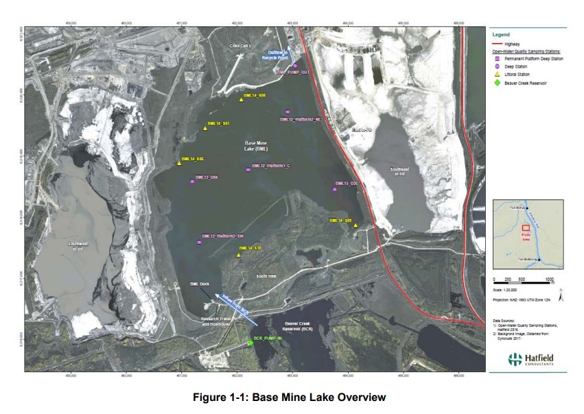
Syncrude's Base Mine Lake (BML) is the first, and currently the only full-scale commercial demonstration of the end pit lake technology in the oil sands industry. An oil sands end pit lake (EPL) is an...
Resource
Syncrude first began investigating the Water-Capped Tailings Technology (WCTT) in the early 1980’s through the establishment of a research program founded on progressive scaled-up testing of water...
Resource
Authors
Don Thompson
Dave Ealey
K.H. McCourt
Major gaps in the baseline knowledge of woodland caribou were: distribution , seasonal habitat use, the effects of sensory disturbance, and population density; minor gap re: direct mortality
Resource
Summarize surveys and some research of a distinctly applied nature and to describe the manner in which AOSERP was carried out. Extensive research will be required to develop a predictive capability
Resource
Authors
Stuart Smith
A.S. Mann
Bob Hursey
Reid Seidner
B. Kasinska-Banas
Interim Report summarizes AOSERP research from April 1975 to November 1978. The investigations referred to herein involved over 100 researchers from government agencies, universities, and consultants
Resource
Authors
Don Thompson
Dave Ealey
K.H. McCourt
An analysis of the applied research necessary to allow evaluation of the effects of oil sands development on large mammals by a review and evaluation of the available baseline data
Resource
Fur value produced per square kilometre averaged $7.58 ($19.64/mi2) but ranged more than 500-fold, with much variation seeming attributable to trapper effort. 5% of traplines reported nil catches
Resource
Report focuses on evolution and current state of pertinent federal legislative Acts in the environmental, natural resource, and energy policy sectors that may impact oil sands environmental management
Resource
Authors
Marcus Becker
Dave Huggard
Melanie Dickie
Camille Warbington
Jim Schieck
Emily Herdman
Robert Serrouya
Stan Boutin
Estimating animal abundance and density are fundamental goals of many wildlife monitoring programs. Camera trapping has become an increasingly popular tool to achieve these monitoring goals due to...
Resource
The cold climate and short growing season characteristic of the major oil and gas producing regions of western Canada make it particularly important to conduct phytoremediation research on plants...
Resource
Authors
Brian Fuhr
Dave Rose
Dave Taplin
A catalogue containing 22 technologies for reducing the environmental impact of fine tailings derived from oil sand processing has been assembled
Resource
Organic constituents of wastewaters discharged from the GCOS plant and Syncrude Canada Ltd. lease No. 17 were characterized and compared to those occurring naturally in the Athabasca River
Resource
Authors
Alberta Centre for Reclamation and Restoration Ecology
Oil Sands Research and Information Network
One of the core mandates for the Oil Sands Research and Information Network (OSRIN) was to enhance access to oil sands environmental management information. With OSRIN’s mandate ending December 31...
Resource
Authors
Sandra Landsburg
Elizabeth Dwyer
Dissipation of bromacil in Humic Luvic Gleysols amended with cow manure was evaluated at two sites in northwestern Alberta from 1984 to 1987
Resource
Authors
Terry Larsen
A. Sorensen
C. McClelland
Gordon Stenhouse
To understand how oil and gas activities and access control measures, particularly gates, influences grizzly bears and their habitats in Alberta, we used multiple data sources including spatial layers...
Resource
Authors
Oil Sands Research and Information Network
Glossary provides understanding of the language and acronyms used in oil sands mining, processing and environmental management.
Resource
Authors
Kimberly Dawe
Erin Bayne
Stan Boutin
This resource is available on an external database and may require a paid subscription to access it. It is included on the CCLM to support our goal of capturing and sharing the breadth of all...
Resource
Objectives of the waterfowl surveys are: 1) To monitor waterfowl migrations through the Syncrude Lease 17 and general area during all seasons of use. 2) To establish the locations and intensity of use
Resource
Authors
Ken Foster
Christine Godwin
Peter Pyle
The MAPS protocol (Monitoring Avian Productivity and Survivorship) was applied in a 2011 pilot program in the boreal forest in the oil sands region
Resource
Remediation professionals, regulators, industry and stakeholders must begin discussions to resolve uncertainty around oil sands COPCs so that efforts can be focused on solving the “real” problem