Land Management Search Results
Resource
Authors
J.P. Verschuren
L. Wojtiw
Point measurements of maximum depth showed that over 50% of the rainstorms occur in June and July, with only a small percentage in April (5.6) and September (10. 1).
Resource
Authors
Jian Zhang
Scott Nielsen
Jessica Stolar
Youhua Chen
Wilfried Thuiller
We found that 368 species (24%) may lose on average > 80% of their current suitable climates (habitats), while 539 species (35%) were projected to more than double their current suitable range
Resource
Authors
Government of British Columbia
This primer is for staff of local governments in BC and is intended to help them capitalize on the real and immediate benefits of managing their natural assets.
Resource
Authors
Alberta Environment and Parks
Canada is a party to the UN Convention on Biological Diversity, which identifies the conservation and restoration of biological diversity as a global priority. It is incumbent on the provinces and...
Resource
Resource Date:
September
2017
This brief presents evidence of land use planning, spatial planning, territorial (or regional) planning, and ecosystem-based or environmental land use planning as tools that can strengthen land governance, improve economic opportunities based on sustainable management of land resources, and develop land use options that reconcile conservation and development objectives.
Resource
Authors
Dee Patriquin
Alex Zeller
Karen Truman
Rebecca Hay
Sophie Gibbs
This document provides decision-making criteria to assist in various aspects of roadway design and operation for management of sustainable road systems
Resource
The objective of this project was to conduct a comprehensive market assessment of the native plant industry
Resource
Authors
Shauna-Lee Chai
Amy Nixon
Scott Nielsen
Assessed 16 potentially new invasive plant species not yet present in Alberta for their invasiveness and climate change-related risk
Resource
Authors
Bonnie Drozdowski
Craig Aumann
Chris Powter
Report of a seminar to develop a collective understanding of the benefits and opportunities of Predictive Soil Mapping as they relate to Alberta
Resource
These guidelines are designed to help land users minimize, or avoid, potential adverse effects on selected wildlife and wildlife resources when conducting activities on public and private lands within...
Resource
Diesel invert wastes are one of the more difficult types of drilling mud wastes to dispose of due to the presence of hydrocarbons and salts. In 1989 a joint research program funded by the Alberta...
Resource
Authors
Karen Cannon
Sandra Landsburg
Concerns about soil compaction on pipeline rights-of-way have increased with the introduction of heavier, more powerful construction equipment
Resource
The Peace River Coal Block in B.C. extends a distance of 150 miles from the Williston reservoir to the Alberta border. Approximately seven hundred and fifty Coal Licences are involved, each one mile...
Resource
Reviews what is currently known of fish ecology and production of the Athabasca Basin, and includes discussions of fish production, sport and commercial use of fish populations
Resource
Authors
Amy Nixon
Christopher Shank
Dan Farr
The Biodiversity Management and Climate Change Adaptation project has produced a comprehensive, evidence-based, and original examination of the effects of climate change on Alberta’s biodiversity
Resource
The presentation describes the purpose and development of a water purification model that can be used to help decision-makers evaluate tradeoffs for land use development proposals
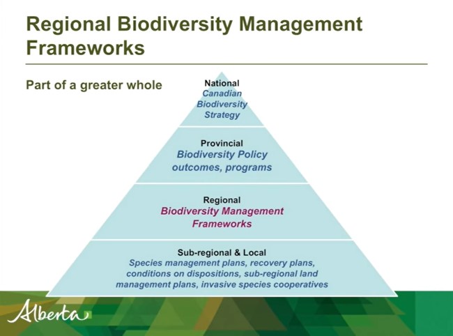
Resource
Authors
Shannon White
Jim Herbers
Jasmine Janes
Sarah Depoe
Shannon R. White is the Biodiversity Specialist for the Land-use Framework Regional Planning Branch for ESRD. She discusses Biodiversity Management Frameworks (BMFs), including indicators, triggers...
Resource
Authors
Anne Naeth
Konstantin Dlusskiy
Leonard Leskiw
Chris Powter
Andy Etmanski
Humans impact everything, including our soil. We remove, mix and compact soil horizons. We add amendments, including waste materials, to replace soil or improve its health. Soils that that have been...
Resource
The goal of the program is to develop a set of spatially explicit models that can be used to map the supply and economic value ecosystems goods and services
Resource
The presentation describes how multi-temporal remote sensing offers a better understanding of landscape changes over time in comparison to the more traditional two-date, before and after comparison.