Land Management Search Results
Resource
Site preparation, forest regeneration, and vegetation management are all important aspects of silviculture and reclamation. Multiple techniques and practices can optimize the success of reclamation...
Resource
Authors
Karen Cannon
Sandra Landsburg
Concerns about soil compaction on pipeline rights-of-way have increased with the introduction of heavier, more powerful construction equipment
Resource
Authors
Manitoba Agriculture, Food and Rural Initiatives
Soil management, or soil conservation, deals with some aspect of protecting soil resources and using soils in a sustainable manner.
Resource
Soil microorganisms and their activities are the major vectors in the decomposition of plant litter and the subsequent transformation and flow of such essential plant nutrients as nitrogen and phospho
Resource
Authors
Anne Naeth
Donna White
David Chanasyk
Terry Macyk
Chris Powter
Don Thacker
To provide coordinated direction for reclamation research in Alberta, the need to review the current understanding and the role of soil physical properties in soil disturbance related activities was...
Resource
Authors
Alberta Soils Advisory Committee
Land disturbances due to resource extraction and transport are intended to be only temporary disruptions to the normal use of land for food and fiber production or for recreation. Although no two...
Resource
Authors
Pedocan Land Evaluation Ltd.
Part 1 of this manual is a background and explanatory section that describes the terminology used in soil surveys and presents the assumptions and conventions upon which the interpretations are based
Resource
Authors
Pedocan Land Evaluation Ltd.
Part 2 presents typical data and interpretations for each soil series in Alberta. The interpretations were made by applying the guidelines in Part 1, and checking the results against experience
Resource
Authors
InnoTech Alberta
University of Alberta
The InnoTech/UofA above ground mesocosm facility enables configurable, innovative approaches for assessing potential environmental and ecological impacts of industrial activities
Resource
This study examined three pervasive issues that impacted native ecosystems. Numerous land use practices including oil and gas activities have led to the modification of native grasslands both the...
Resource
Authors
Stephen Moran
John Cherry
In reconstructing the landscape during reclamation the sequence and methods of placement of overburden material determine the post-mining subsurface-water chemistry. The type of material at various...
Resource
Authors
Craig DeMars
Kendal Benesh
The boreal ecotype of woodland caribou ( Rangifer tarandus caribou) is provincially Red-listed in British Columbia and federally listed as Threatened. Population declines of boreal caribou have been...
Resource
UAV-based remote sensing as a method for monitoring well pad recovery is determined to be feasible from a technical and field perspective.
Resource
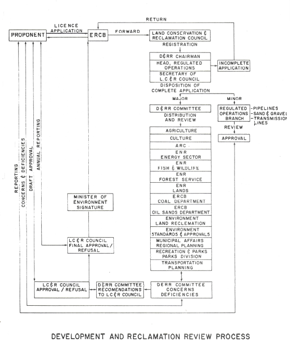
The Development and Reclamation Review process, as it currently operates, is presented and discussed with the aid of a flow chart. Suggestions are made to improve and expedite the process with...
Resource
Authors
L.M. McKinnon
A.K. Mitchell
A. Vyse
In forestry, the purpose of site preparation is to ameliorate environmental conditions which limit tree seedling survival and growth. In subalpine and boreal forests, low soil temperature in...
Resource
Authors
Rachel Hovel
Jeremy Brammer
Emma Hodgson
Amy Amos
Trevor Lantz
Chanda Turner
Tracey Proverbs
Sarah Lord
Rapid environmental change in the Arctic elicits numerous concerns for ecosystems, natural resources, and ways of life. Robust monitoring is essential to adaptation and management in light of these...
Resource
Authors
Erin Bayne
Cameron Nordell
Jesse Watson
Melynda Johnson
Adam Moltzahn
Janet Ng
The Ferruginous Hawk (FEHA) has been listed as an Endangered Species under the Alberta Wildlife Act by the provincial government since 2006 (Alberta FEHA Recovery Team 2009); and were re-listed as a...
Resource
Study concentrated on the well-documented 1981 right-of-way, and compared it to the oldest trench, installed in 1957, and to the undisturbed adjacent mixed prairie
Resource
Authors
Guillermo Castilla
Ronald Hall
Rob Skakun
Michelle Filiatrault
André Beaudoin
Michael Gartrell
Lisa Smith
Kathleen Groenewegen
Chris Hopkinson
Jurjen van der Sluijs
Resource Date:
February
2022
Wall-to-wall 30 m raster maps of broad forest type, stand height, crown closure, stand volume, total volume, aboveground biomass, and stand age were created for a ~400,000 km2 area, validated with independent data, and generalized into a polygon GIS layer resembling a traditional FI map. The MVI project showed that a reasonably accurate FI map for large, remote, predominantly non-inventoried boreal regions can be obtained at a low cost by combining limited field data with remote sensing data from multiple sources.
Resource
Authors
Majid Iravani
Monica Kohler
Shannon White
The results showed a pronounced variation in the historic supply of soil organic carbon and aboveground biomass in the watershed. Land management resulted in a diverse range of gains or losses.