Land Management Search Results
Resource
Breeding bird studies using the mapping method were combined with intensive habitat quantification to determine the relative values to breeding avifauna of 21 habitat types
Resource
Authors
Corey Scobie
Alan Marsh
Ryan Fisher
Erin Bayne
Troy Wellicome
Petroleum development has occurred at a rapid pace on the grasslands of Alberta and Saskatchewan. To avoid potential impacts of development on burrowing owls, federal and provincial governments...
Resource
Authors
Boreal Avian Modelling Project
Bioclimatic niche models of current avian distribution and density for 80 boreal-breeding songbird species are mapped based on present counts and climate change models
Resource
Authors
Ken Foster
Christine Godwin
Peter Pyle
The MAPS protocol (Monitoring Avian Productivity and Survivorship) was applied in a 2011 pilot program in the boreal forest in the oil sands region
Resource
Authors
Shauna-Lee Chai
Amy Nixon
Scott Nielsen
Assessed 16 potentially new invasive plant species not yet present in Alberta for their invasiveness and climate change-related risk
Resource
Authors
A. Brown
M.J. Kent
J.O. Park
R.D. Roberts
3 aspects of aquatic habitat assessment and mapping. 1 - review of the parameters which characterize aquatic habitats. 2 - efficient procedure for collecting the data. 3 - computer mapping techniques
Resource
Authors
Alberta Biodiversity Monitoring Institute
Boreal caribou populations are declining across Alberta and much of their Canadian range. Key factors causing this decline include a warming climate along with habitat change from industrial...
Resource
Authors
Alberta Biodiversity Monitoring Institute
Seismic lines and other linear features created by humans are thought to negatively impact woodland caribou. It is estimated that there are c. 100,000 km of conventional seismic lines in caribou...
Resource
Authors
Amy Nixon
Ryan Fisher
Diana Stralberg
Erin Bayne
Climate suitability projections, and current distribution of grassland and cropland habitats in Alberta suggest that some climate-mediated range expansion of grassland songbirds is possible
Resource
Authors
Natalie Sánchez
Luis Sandoval
Richard Hedley
Colleen St. Clair
Erin Bayne
Anthropogenic noise can create an acoustic environment detrimental for animals that communicate using acoustic signals. Currently, most studies of noise and wildlife come from traffic noise in cities...
Resource
Authors
Howard Baldwin
Bryant Bidgood
Design techniques are presented for a very high frequency telemetry system capable of transmitting short radio frequency pulse signals from the body of a fish to an aircraft flying over a river.
Resource
Authors
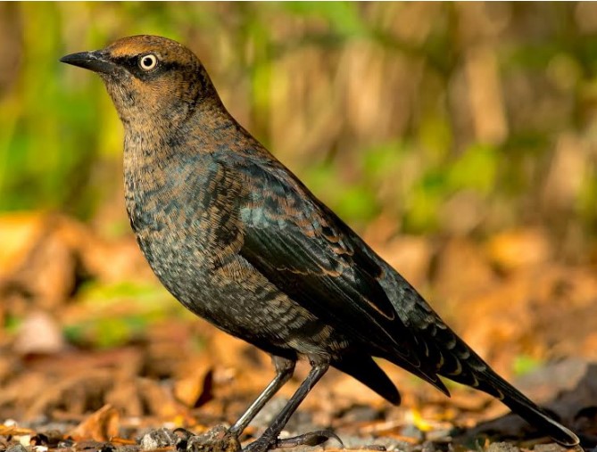
Cameron Nordell
Erin Bayne
The Rusty Blackbird ( Euphagus carolinus ) was listed as Special Concern on Schedule 1 of the federal Species at Risk Act in March 2009 because of large and longterm declines in population size. The...
Resource
Authors
Anna Dabros
Kellina Higgins
Jaime Pinzon
This resource is available on an external database and may require a paid subscription to access it. It is included on the CCLM to support our goal of capturing and sharing the breadth of all...
Resource
Authors
Alberta Biodiversity Monitoring Institute
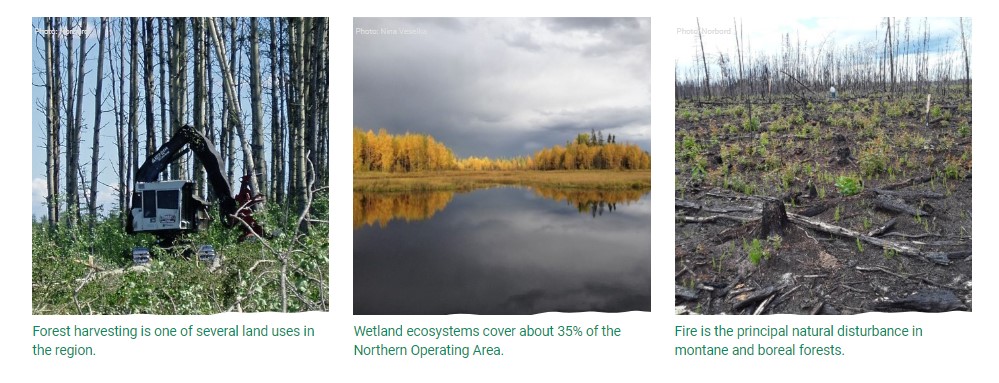
This online report describes the status of human footprint, species, and habitat in Norbord Inc.'s two main operating areas located in northwestern Alberta. This information establishes baseline...
Resource
Authors
Rachel Hovel
Jeremy Brammer
Emma Hodgson
Amy Amos
Trevor Lantz
Chanda Turner
Tracey Proverbs
Sarah Lord
Rapid environmental change in the Arctic elicits numerous concerns for ecosystems, natural resources, and ways of life. Robust monitoring is essential to adaptation and management in light of these...
Resource
Authors
Alberta Biodiversity Monitoring Institute
As of 2010, human footprint in the Active In-situ Region was 7.7%, whereas it was 20.8% in the Mineable Region. Total human footprint in all Woodland Caribou ranges increased between 2007 and 2010
Resource
Authors
Alberta Biodiversity Monitoring Institute
As of 2012, the total human footprint across the OSR was 13.8%. Energy footprint covered 2.2% of the OSR. The total human footprint in the OSR increased from 11.3% to 13.8% between 1999 and 2012.
Resource
Authors
Alberta Biodiversity Monitoring Institute
This report presents data on several indicators of environmental health for the Kakwa River Project area where ARC Resources operates in northwestern Alberta. The Kakwa River Project area covers...
Resource
The presentation covers the use of remote sensing in assessing biodiversity and how using covariate data can improve on the interpretation of results
Resource
Oil sands industry case study evaluated the economic and ecological performance of alternative offset networks targeting either ecologically equivalent areas or regional conservation priorities