Land Management Search Results
Resource
Authors
Randy Rudolph
M.M. Oleskiw
R.A. Stuart
Climatological analysis of recent data from the MAPS network of automatic meteorological data acquisition, forestry lookout stations, minisondes, pack surveys, and the Fort McMurray station
Resource
Authors
Alex Schumacher
Reinhard Hermesh
Antoine Bedwany
The study involved an examination of the vegetation and spoils on five mine locations in the central Parkland of Alberta. These five locations represented different spoil types, and methods of mining...
Resource
Authors
Chris Powter
Brent Scorfield
Brent Lakeman
Shane Patterson
The development of integrated geomatics and remote sensing technologies for environmental management holds promise to meet economic diversification and effective environmental management.
Resource
Scenarios of expected concurrent flow along the Athabasca River are developed on the assumption that a 7Q10 event occurs at either Hinton, Whitecourt, Athabasca, or Fort McMurray
Resource
Authors
Diana Stralberg
Erin Bayne
Steven Cumming
Péter Sólymos
Samantha Song
Fiona Schmiegelow
For some boreal songbirds, limits to forest growth and succession may result in dramatic reductions in suitable habitat over the next century.
Resource
Although ecological transitions are expected to be widespread, under even the least-change climate scenario, ecological change is not synonymous with the loss of biodiversity.
Resource
Program to address the extensive problems of biting flies in agriculture and provide information for management of black flies that occur during development of resource and recreational industries
Resource
This document contains 21 technical reports supporting the chemical control of S. arcticum in the Athabasca River program studies.
Resource
Authors
Renewable Resources Consulting Ltd.
Control rodent damage by: (1) Planting trees and shrubs when rodent numbers are at the low or declining phase of their cycle, and (2) Manipulating rodent numbers by manipulating vegetative cover.
Resource
Authors
Marvin Nyborg
R.W. Parker
Sam Takyi
Paul Yeung
Several field investigations were carried out to determine the amounts of sulphur deposited in rain, in rain washing off trees, and by direct absorption of SO2 by soil
Resource
Annosus root and butt rot was first reported in Quebec in 1989. The causal fungus enters a pine stand by colonizing the surface of freshly cut stumps. The disease spreads through contact between the...
Resource
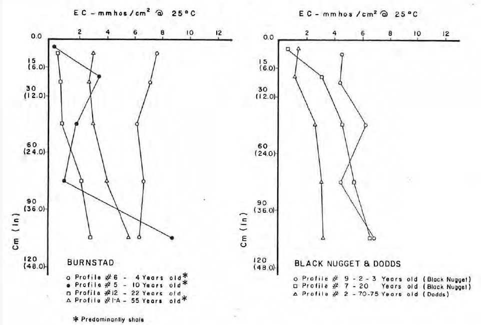
Soils sampled at sites 2.3 and 5.3 km south of the Great Canadian Oil Sands (GCOS) plant, Fort McMurray, respectively were found to differ statistically with reference to several macronutrients
Resource
Over 70 diseases have been found and recorded on black spruce ( Picea mariana [Mill.] B.S.P.) in Ontario (Davis and Myren 1990). They range from vigorous pathogens capable of causing death or serious...
Resource
Synthesis of the published literature on the habitat preferences of beavers, muskrats, mink and river otters. Field studies during the late autumn of 1978 included aerial surveys and track counts
Resource
348 benthic macroinvertebrate samples collected at 16 sites along 85 km of the Athabasca River between Fort McMurray and the Ells River. total of 27229 specimens belonging to 68 taxonomic groups
Resource
Authors
Terry Larsen
A. Sorensen
C. McClelland
Gordon Stenhouse
To understand how oil and gas activities and access control measures, particularly gates, influences grizzly bears and their habitats in Alberta, we used multiple data sources including spatial layers...
Resource
Authors
Roger DeAbreu
Shane Patterson
Todd Shipman
Chris Powter
NRCan pilot science projects have proven that Earth Observation can provide relevant and valuable information to inform and enhance monitoring and support regulatory frameworks
Resource
Authors
M.D. Thompson
M.C. Wride
M.E. Kirby
Classification system devised for mapping vegetation and surficial geology from 1:60,000 scale false colour infrared photographs; 1:50 000 base maps plus a vegetation and a surficial geology overlay
Resource
Ground surveys of vegetation and surficial geology generally confirmed that the classification systems used in the mapping accurately described and defined the ecological habitat features
Resource
Describe basic ecology of aquatic benthic macrofauna of the Athabasca River and its major tributaries, the Muskeg and Steepbank rivers