Land Management Search Results
Resource
From 1981 to 1984, nineteen experimental plantations were established on a range of eight typical reforested sectors in seven regions of Quebec. Included in the experiments, which took place during...
Resource
Authors
Alberta Biodiversity Monitoring Institute
Boreal caribou populations are declining across Alberta and much of their Canadian range. Key factors causing this decline include a warming climate along with habitat change from industrial...
Resource
Authors
Alberta Biodiversity Monitoring Institute
Seismic lines and other linear features created by humans are thought to negatively impact woodland caribou. It is estimated that there are c. 100,000 km of conventional seismic lines in caribou...
Resource
Authors
Alberta Biodiversity Monitoring Institute
Resource Date:
January
2020
Linear features, including seismic lines, pipelines, transmission lines, roads, railways, and trails are pervasive in Alberta’s boreal forest and have been implicated as a primary factor leading to...
Resource
Authors
Mike Ostafichuk
George LaRoi
Of the 16 permanent plots established in 1981, four of these, Nos. 1,6,11, and 13 were destroyed by fire shortly after they were surveyed. In 1982, four new plots were established to replace the...
Resource
Authors
Amy Nixon
Ryan Fisher
Diana Stralberg
Erin Bayne
Climate suitability projections, and current distribution of grassland and cropland habitats in Alberta suggest that some climate-mediated range expansion of grassland songbirds is possible
Resource
Authors
Anne Naeth
Albert Lees
Jeanie Bietz
B.D. Irving
Al Fedkenheuer
Compare vegetative productivity, plant species composition and animal utilization on pipeline right-of-way to that of the adjacent native grassland. Field assessments were conducted over 4 years
Resource
Authors
Virgil Hawkes
Gillian Donald
A long-term plot network would allow the monitoring data to describe the ecological condition of the reclaimed lands and define appropriate management strategies for achieving revegetation goals
Resource
Authors
Mar Martinez
Gary Borstad
Leslie Brown
Kaan Ersahin
Michael Henley
Monitoring of reclaimed sites is a complex, interdisciplinary undertaking, especially in large, disturbed areas with difficult access. In that context, remote sensing is a unique and valuable tool...
Resource
Authors
R.J. Hall
J.J. van der Sanden
J.T. Freeburn
S.J. Thomas
The objective of this report is to review the requirements for disturbance information, the manifestation of damage patterns that may be encountered, and to provide an overview of remote sensing...
Resource
Authors
Howard Baldwin
Bryant Bidgood
Design techniques are presented for a very high frequency telemetry system capable of transmitting short radio frequency pulse signals from the body of a fish to an aircraft flying over a river.
Resource
Provides recommendations based on the field survey and ground checking, for developing methodologies to enhance the detail on 1:50 000 vegetation maps (preliminary vegetation community classification)
Resource
Authors
Cameron Nordell
Erin Bayne
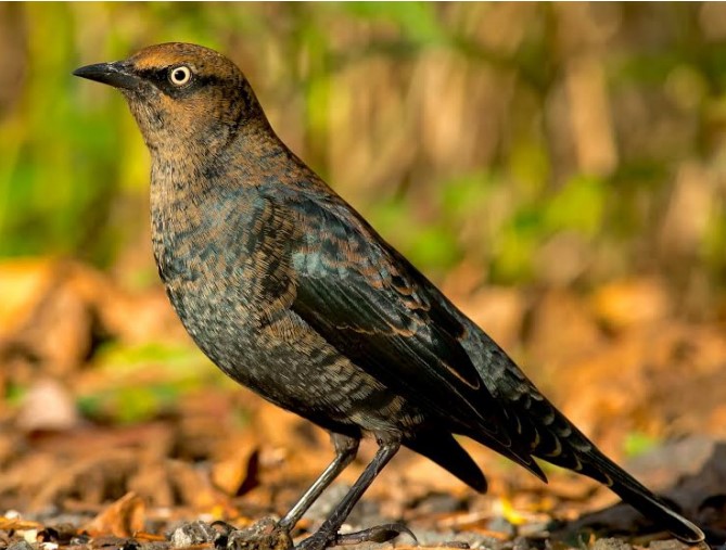
The Rusty Blackbird ( Euphagus carolinus ) was listed as Special Concern on Schedule 1 of the federal Species at Risk Act in March 2009 because of large and longterm declines in population size. The...
Resource
This thesis investigates the effectiveness of machine learning algorithms for automatic detection of coniferous seedling data along Boreal seismic lines. In order to obtain a survival assessment and...
Resource
Authors
D.G. Maynard
K. E. Hogg
E.F. Wass
M.P. Curran
Soil disturbance from forest harvesting has been shown to compromise site productivity. We established satellite trials in five of the Long-Term Soil Productivity (LTSP) sites in southeast British...
Resource
Authors
Anne Naeth
Donna White
David Chanasyk
Terry Macyk
Chris Powter
Don Thacker
To provide coordinated direction for reclamation research in Alberta, the need to review the current understanding and the role of soil physical properties in soil disturbance related activities was...
Resource
Authors
Pedocan Land Evaluation Ltd.
Part 1 of this manual is a background and explanatory section that describes the terminology used in soil surveys and presents the assumptions and conventions upon which the interpretations are based
Resource
Authors
Pedocan Land Evaluation Ltd.
Part 2 presents typical data and interpretations for each soil series in Alberta. The interpretations were made by applying the guidelines in Part 1, and checking the results against experience
Resource
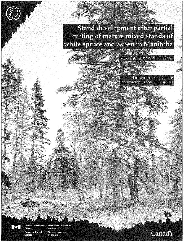
One-hundred-year-old mixed white spruce–aspen stands were partially cut in 1953, 1954, and 1955 and scarified leaving treatments that retained 14–100% of total stand basal area. Composition of the...
Resource
Authors
Alberta Biodiversity Monitoring Institute
This online report describes the status of human footprint, species, and habitat in Norbord Inc.'s two main operating areas located in northwestern Alberta. This information establishes baseline...