Land Management Search Results
Resource
Authors
Alberta Biodiversity Monitoring Institute
Resource Date:
January
2020
Linear features, including seismic lines, pipelines, transmission lines, roads, railways, and trails are pervasive in Alberta’s boreal forest and have been implicated as a primary factor leading to...
Resource
Authors
A. Wotherspoon
N. Thiffault
R.L. Bradley
Scarification is a mechanical site preparation technique designed to create microsites that will favor the growth of planted tree seedlings after clearcutting. However, the positive growth response of...
Resource
Authors
Ginny Marshall
Dan Thompson
Kerry Anderson
Brian Simpson
Current methods of predicting fire spread in Canadian forests are suited to large wildfires that spread through natural forests. Recently, the use of mechanical and thinning treatments of forests in...
Resource
Authors
Rachel Hovel
Jeremy Brammer
Emma Hodgson
Amy Amos
Trevor Lantz
Chanda Turner
Tracey Proverbs
Sarah Lord
Rapid environmental change in the Arctic elicits numerous concerns for ecosystems, natural resources, and ways of life. Robust monitoring is essential to adaptation and management in light of these...
Resource
Authors
Majid Iravani
Monica Kohler
Shannon White
The results showed a pronounced variation in the historic supply of soil organic carbon and aboveground biomass in the watershed. Land management resulted in a diverse range of gains or losses.
Resource
Authors
Randi Lupardus
Ermias Azeria
Kierann Santala
Isabelle Aubin
Anne McIntosh
Results suggest that even as practices and policies evolve, reclamation does not fully alleviate the legacy effects of industrial disturbance. Trait-based approaches can inform recovery assessment.
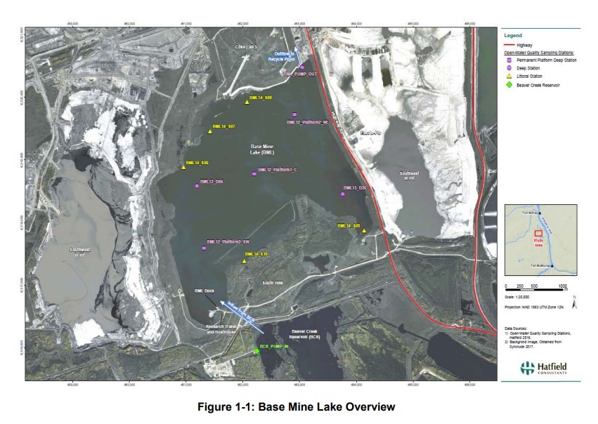
Resource
Syncrude's Base Mine Lake (BML) is the first, and currently the only full-scale commercial demonstration of the end pit lake technology in the oil sands industry. An oil sands end pit lake (EPL) is an...
Resource
Authors
Wei-Yew Chang
Chris Gaston
Julie Cool
Barb Thomas
Genomics-assisted tree breeding (GATB) is an emerging biotechnology method that has the potential to produce improved planting stock in selected traits, such as greater volume or higher wood quality...
Resource
Authors
Marc-André Parisien
Denyse Dawe
Carol Miller
Christopher Stockdale
Bradley Armitage
Wildland fire scientists and land managers working in fire-prone areas require spatial estimates of wildfire potential. To fulfill this need, a simulation-modelling approach was developed whereby...
Resource
Authors
Piotr Tompalski
Joseph Rakofsky
Nicholas Coops
Joanne White
Alexander Graham
Kyle Rosychuk
Airborne laser scanning (ALS) and digital aerial photogrammetry (DAP) have both been demonstrated as reliable sources of information on forest stand inventory attributes. The increasing availability...
Resource
Authors
Christopher Stockdale
Neal McLoughlin
Mike Flannigan
Ellen Macdonald
Montane regions throughout western North America have experienced closures of forest cover and increases of forest encroachment into grasslands due to climate change and fire suppression. These...
Resource
Authors
Gustavo Queiroz
Gregory McDermid
Guillermo Castilla
Julia Linke
Mir Rahman
Coarse woody debris (CWD; large parts of dead trees) is a vital element of forest ecosystems, playing an important role in nutrient cycling, carbon storage, fire fuel, microhabitats, and overall...
Resource
Authors
Anne McIntosh
Bonnie Drozdowski
Dani Degenhardt
Chris Powter
Christina Small
John Begg
Dan Farr
Arnold Janz
Randi Lupardus
Delinda Ryerson
Jim Schieck
Scientifically robust monitoring protocol to enable consistent assessment of ecological recovery of physical, chemical, and biological indicators at certified reclaimed well pads on grasslands.
Resource
One of the neat things about working in environmental monitoring is the sheer range of tools available to use, and the rate at which they’re evolving. One example that’s rapidly changing monitoring...
Resource
Authors
Alberta Biodiversity Monitoring Institute
As of 2015, 29.2% of Alberta is under human footprint, up from 25.7% in 1999—that’s an average increase of about 0.22%, or around 1450 km2 (560 sections) per year.
Resource
Authors
Alberta Biodiversity Monitoring Institute
From1999 to 2015, human activity in Alberta visibly converted over 23,000 km2 of native ecosystems into residential, recreational, or industrial landscapes
Resource
The Emend for Schools: 360° Video EMEND Tour Teachers Resource is a full lesson plan and 360 immersive and interactive video teaching tool, including a teacher lesson plan and student workbook aligned...
Resource
Authors
Mighty Peace Watershed Alliance
The Mighty Peace Watershed Alliance (MPWA) supports the three goals of Alberta’s Water for Life Strategy: safe secure drinking water, healthy aquatic ecosystems, and reliable, quality water supplies...
Resource
Authors
Megan Hornseth
Karine Pigeon
Doug MacNearney
Terrence Larsen
Gordon Stenhouse
Jerome Cranston
Laura Finnegan
Natural regeneration of seismic lines, cleared for hydrocarbon exploration, is slow and often hindered by vegetation damage, soil compaction, and motorized human activity. There is an extensive...
Resource
This thesis investigates the effectiveness of machine learning algorithms for automatic detection of coniferous seedling data along Boreal seismic lines. In order to obtain a survival assessment and...