Land Management Search Results
Resource
Authors
Roger DeAbreu
Shane Patterson
Todd Shipman
Chris Powter
NRCan pilot science projects have proven that Earth Observation can provide relevant and valuable information to inform and enhance monitoring and support regulatory frameworks
Resource
Authors
Christopher Shank
Erin Bayne
The Alberta Ferruginous Hawk Recovery Plan 2009 – 2014 identifies climate change as a factor potentially threatening the recovery of the species in Alberta.
Resource
Authors
Stephen Mayor
Stan Boutin
Fangliang He
James Cahill
Rank species occupancy curves revealed high species dominance regardless of disturbance: within any disturbance class a few species occupied nearly every site and most species were found in a low...
Resource
Authors
Amy Nixon
Ryan Fisher
Diana Stralberg
Erin Bayne
Climate suitability projections, and current distribution of grassland and cropland habitats in Alberta suggest that some climate-mediated range expansion of grassland songbirds is possible
Resource
Authors
Amy Nixon
Christopher Shank
Dan Farr
The Biodiversity Management and Climate Change Adaptation project has produced a comprehensive, evidence-based, and original examination of the effects of climate change on Alberta’s biodiversity
Resource
Authors
Shannon White
Jim Herbers
Jasmine Janes
Sarah Depoe
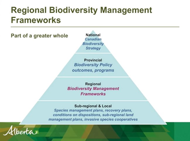
Shannon R. White is the Biodiversity Specialist for the Land-use Framework Regional Planning Branch for ESRD. She discusses Biodiversity Management Frameworks (BMFs), including indicators, triggers...
Resource
Presentation tracks the evolution in technology used to monitor birds by recording their songs, with examples from different regions of the province.
Resource
The presentation describes ABMI's role in collecting monitoring data and how the data can be used in environmental management.
Resource
Authors
Chris Johnson
Libby Ehlers
Dale Seip
This resource is available on an external database and may require a paid subscription to access it. It is included on the CCLM to support our goal of capturing and sharing the breadth of all...
Resource
Authors
Cole Burton
Dave Huggard
Erin Bayne
Jim Schieck
Péter Sólymos
Tyler Muhly
Dan Farr
Stan Boutin
Effective ecological monitoring is imperative in a human-dominated world, as our ability to manage functioning ecosystems will depend on understanding biodiversity responses to anthropogenic impacts...
Resource
Authors
Leila Taheriazad
Carlos Portillo-Quintero
Arturo Sanchez-Azofeifa
This report presents a comprehensive review of industrial applications of an emerging environmental monitoring technology called Wireless Sensor Networks (WSN) and a WSN installed at Coal Valley Mine
Resource
Authors
Alberta Biodiversity Monitoring Institute
In summer 2013 field crews spent five weeks sampling soil and vegetation indicators at 18 wellsites and adjacent reference sites in the Dry Mixedgrass subregion of Alberta
Resource
Authors
Jean Birks
Yi Yi
Sunny Cho
Emily Taylor
John Gibson
This study was conducted to characterize the composition of polar dissolved organic compounds present in snow and surface waters in the Athabasca Oil Sands Region (AOSR) with the goal of identifying...
Resource
Authors
Alberta Biodiversity Monitoring Institute
Select appropriate vegetation, soil, and habitat indicators for a long-term reclamation monitoring program and provide sampling protocols for the selected indicators.
Resource
Our statistical design and the hands on learning experience we gained in the field can be applied when implementing the long-term monitoring program for certified wellsites.
Resource
Authors
Alberta Biodiversity Monitoring Institute
Three workshops were held to examine a suite of vegetation, soil, and habitat indicators that could potentially be used to monitor recovery in a long-term reclamation monitoring program
Resource
Data show that for many vegetation and soil indicators, wellsite development impacts are long lasting and may remain for 30 years or more after reclamation.
Resource
Authors
Nadia Rochdi
J. Zhang
Karl Staenz
X. Yang
D. Rolfson
J. Banting
C. King
R. Doherty
Scope of the project is to develop a geomatics-based monitoring system to support the Government of Alberta’s efforts for monitoring reclamation success. Software will support decision making process
Resource
Mapping of oil reserves involves the use of seismic lines (linear disturbances) to determine size of reserves. These linear disturbances fragment forests and in many cases fail to regenerate trees...
Resource
Authors
D.G. Maynard
K. E. Hogg
E.F. Wass
M.P. Curran
Soil disturbance from forest harvesting has been shown to compromise site productivity. We established satellite trials in five of the Long-Term Soil Productivity (LTSP) sites in southeast British...