Wetlands Knowledge Search Results
Resource
While a total of 11 species were encountered in the study area, only 6 were recorded in the upper diversion system (i.e., upstream of the Poplar Creek dam).
Resource
The fish populations of the Athabasca River downstream of Fort McMurray were sampled during the open-water period in 1976 and 1977. Twenty-seven fish species were identified from the Athabasca River,
Resource
Results of work done in 1976, the first year of a two-year study intended to evaluate and describe the baseline state of the fish resources of the Athabasca River downstream of Fort McMurray
Resource
During 1977, the second year of a two-year study, the fish populations of the Athabasca Rive: were investigated in two general areas downstream of Fort McMurray from mid-April to early November
Resource
Authors
Robert Bott
Graham Chandler
Peter McKenzie-Brown
This book is written to help assess how effectively we have, or are, conserving our land base and providing the stewardship required to pass our legacy on to our progeny.
Resource
Authors
J.E. Hurley
J.A. Loo
P. DesRochers
H.E. Hirvonen
Highlights Invasive alien insect and disease species are of increasing concern to the health and economic viability of the forest ecosystems within the ecozone. Brown spruce longhorn beetle, an alien...
Resource
Authors
Stefan Schreiber
Barb Thomas
Resource Date:
March
2017
This resource is available on an external database and may require a paid subscription to access it. It is included on the CCLM to support our goal of capturing and sharing the breadth of all...
Resource
Authors
Sylvain Ménard
Marcel Darveau
Louis Imbeau
Forest inventory maps can be used to quantify the area of wetland habitats and to define homogeneous regions in this regard, and therefore provide a functional tool for coarse-scale wetland management
Resource
Authors
Terrance Power
Robert Cameron
Thomas Neily
Brad Toms
Resource Date:
April
2018
This resource is available on an external database and may require a paid subscription to access it. It is included on the CCLM to support our goal of capturing and sharing the breadth of all...
Resource
Authors
Karla Buffalo
Carol Jones
John Errington
M.I.A. MacLean
In the future, Fort McKay will continue to strive for faster reclamation that will restore the land to pre-mining conditions and seek the complete elimination of fluid fine tailings stored in an EPL
Resource
Authors
Conservation and Utilization Committee
Alberta should regulate and control the Athabasca tar sands development for the socio-economic benefit of Albertans. Rate of development of 1 plant in every 4 years is consistent with present tecnolog
Resource
Authors
Oil Sands Research and Information Network
Current state of knowledge about shrubs and their use in oil sands reclamation noted a number of regulatory requirements and policies that support shrub use but a far larger list of impediments
Resource
Resource Date:
October
2009
This resource is available on an external database and may require a paid subscription to access it. It is included on the CCLM to support our goal of capturing and sharing the breadth of all...
Resource
Authors
United Nations Environment Programme
Resource Date:
November
2022
Peatlands are unique and rare ecosystems that, despite only covering around 3-4% of the planet’s land surface, they contain up to one-third of the world’s soil carbon, which is twice the amount of...
Resource
This glossary was prepared to provide those working in the field of reclamation in Alberta with a standardized set of definitions for reclamation terms.
Resource
Authors
Oil Sands Research and Information Network
Glossary provides understanding of the language and acronyms used in oil sands mining, processing and environmental management.
Resource
Authors
Scientific Enquiry Committee
Evaluate impact of the GCOS tailings discharges on the Athabasca River, and to provide recommendations on any necessary action to be taken by Alberta Environment and Great Canadian Oil Sands Limited.
Resource
Summary of the meteorological data collected by the meteorological tower network in the Gregoire Lake region of northeast Alberta during the spring and summer of 1979 to monitor impact of Amoco plant
Resource
Authors
Jean Birks
John Manchuk
Yi Yi
Cynthia McClain
Michael Moncur
John Gibson
Clayton Deutsch
Emily Taylor
Guy Bayegnak
Groundwater quality data for the AOSR are compiled and interpreted to provide information on regional water quality to inform groundwater monitoring and land use planning. A database of 546 water...
Resource
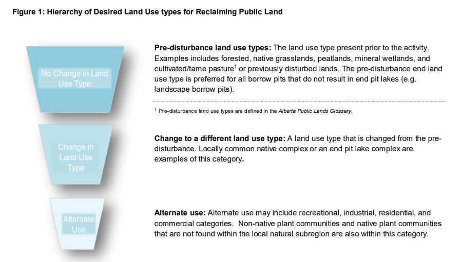
A primary goal of this Guideline is to emphasize the long-standing preference for reclaiming and restoring public lands to the pre-disturbance land use type.