Wetlands Knowledge Search Results
Resource
Authors
Boreal Avian Modelling Project
Bioclimatic niche models of current avian distribution and density for 80 boreal-breeding songbird species are mapped based on present counts and climate change models
Resource
Beavers, Canada's national animal, provide many valuable ecosystem services including storage of water during droughts and flooding, creation of habitat for a variety of species, and improvement of...
Resource
Authors
Larry Turchenek
Wayne Tedder
R. Krzanowski
Methodology for cost-effective soil survey and sampling of cutover peatlands, and obtaining baseline chemical information and data interpretation for peat materials to examine reclamation alternatives
Resource
Authors
Budiman Minasny
Diana Vigah Adetsu
Matt Aitkenhead
Rebekka Artz
Nikki Baggaley
Alexandra Barthelmes
Amélie Beucher
Jean Caron
Giulia Conchedda
John Connolly
Raphaël Deragon
Chris Evans
Kjetil Fadnes
Dian Fiantis
Zisis Gagkas
Louis Gilet
Alessandro Gimona
Stephan Glatzel
Mogens Greve
Wahaj Habib
Kristell Hergoualc’h
Cecilie Hermansen
Darren Kidd
Triven Koganti
Dianna Kopansky
David Large
Tuula Larmola
Allan Lilly
Haojie Liu
Matthew Marcus
Maarit Middleton
Keith Morrison
Rasmus Jes Petersen
Tristan Quaife
Line Rochefort
Rudiyanto
Linda Toca
Francesco Tubiello
Peter Lystbæk Weber
Simon Weldon
Wirastuti Widyatmanti
Jenny Williamson
Dominik Zak
Peatlands cover only 3–4% of the Earth’s surface, but they store nearly 30% of global soil carbon stock. This significant carbon store is under threat as peatlands continue to be degraded at alarming...
Resource
Resource Date:
March
2022
In the discontinuous permafrost zone, thermokarst lakes and thermal erosion are widespread and common permafrost thaw-related phenomena. Thermokarst features are indicative of thaw sensitive...
Resource
Authors
Sophie Wilkinson
Alexander Furukawa
Brian Wotton
James Waddington
This resource is available on an external database and may require a paid subscription to access it. It is included on the CCLM to support our goal of capturing and sharing the breadth of all...
Resource
Authors
Shijuan Chen
Gregory McDermid
Guillermo Castilla
Julia Linke
Resource Date:
December
2017
Monitoring vegetation recovery typically requires ground measurements of vegetation height, which is labor-intensive and time-consuming. Recently, unmanned aerial vehicles (UAVs) have shown great...
Resource
Authors
Megan Hornseth
Karine Pigeon
Doug MacNearney
Terrence Larsen
Gordon Stenhouse
Jerome Cranston
Laura Finnegan
Natural regeneration of seismic lines, cleared for hydrocarbon exploration, is slow and often hindered by vegetation damage, soil compaction, and motorized human activity. There is an extensive...
Resource
Authors
Cassidy van Rensen
Scott Nielsena
Barry White
Tim Vinge
Victor Lieffers
Mapping of oil reserves involves the use of seismic lines (linear disturbances) to determine both their location and extent. Conventional clearing techniques for seismic assessment have left a legacy...
Resource
This project describes a new method for sampling secondary structure in beetle-attacked pine stands and reports on a test of its accuracy. The method consists of interpreting aerial photos taken when...
Resource
Can seedlings intended for reforestation be planted anywhere, regardless of the seed source from which they were obtained? The Optisource software was developed to help forest managers answer this...
Resource
Can seedlings intended for reforestation be planted anywhere, regardless of the seed source from which they were obtained? The Optisource software was developed to help forest managers answer this...
Resource
Authors
Stephen Moran
Terry Macyk
Mark Trudell
Margot Pigot
In 1985, a one hectare pond developed in the upland reclaimed landscape at Vesta Mine in an area where extensive ponding had not previously been observed. Because of the thickness of the spoil, about...
Resource
Authors
Kirsten Lees
Tristan Quaife
Rebekka Artz
Myroslava Khomik
Joanna Clark
Resource Date:
February
2015
Peatlands store large amounts of terrestrial carbon and any changes to their carbon balance could cause large changes in the greenhouse gas (GHG) balance of the Earth's atmosphere. There is still much...
Resource
Authors
Sheel Bansal
Irena Creed
Brian Tangen
Scott Bridgham
Ankur Desai
Ken Krauss
Scott Neubauer
Gregory Noe
Donald Rosenberry
Carl Trettin
Kimberly Wickland
Scott Allen
Ariane Arias‑Ortiz
Anna Armitage
Dennis Baldocchi
Kakoli Banerjee
David Bastviken
Peter Berg
Matthew Bogard
Alex Chow
William Conner
Christopher Craft
Courtney Creamer
Tonya DelSontro
Jamie Duberstein
Meagan Eagle
Siobhan Fennessy
Sarah Finkelstein
Mathias Göckede
Sabine Grunwald
Meghan Halabisky
Ellen Herbert
Mohammad Jahangir
Olivia Johnson
Miriam Jones
Jefrey Kelleway
Sara Knox
Kevin Kroeger
Kevin Kuehn
David Lobb
Amanda Loder
Shizhou Ma
Damien Maher
Gavin McNicol
Jacob Meier
Beth Middleton
Christopher Mills
Purbasha Mistry
Abhijit Mitra
Courtney Mobilian
Charles Schutte
Changchun Song
Camille Stagg
Jessica Turner
Rodrigo Vargas
Mark Waldrop
Marcus Wallin
Zhaohui Aleck Wang
Eric Ward
Debra Willard
Stephanie Yarwood
Xiaoyan Zhu
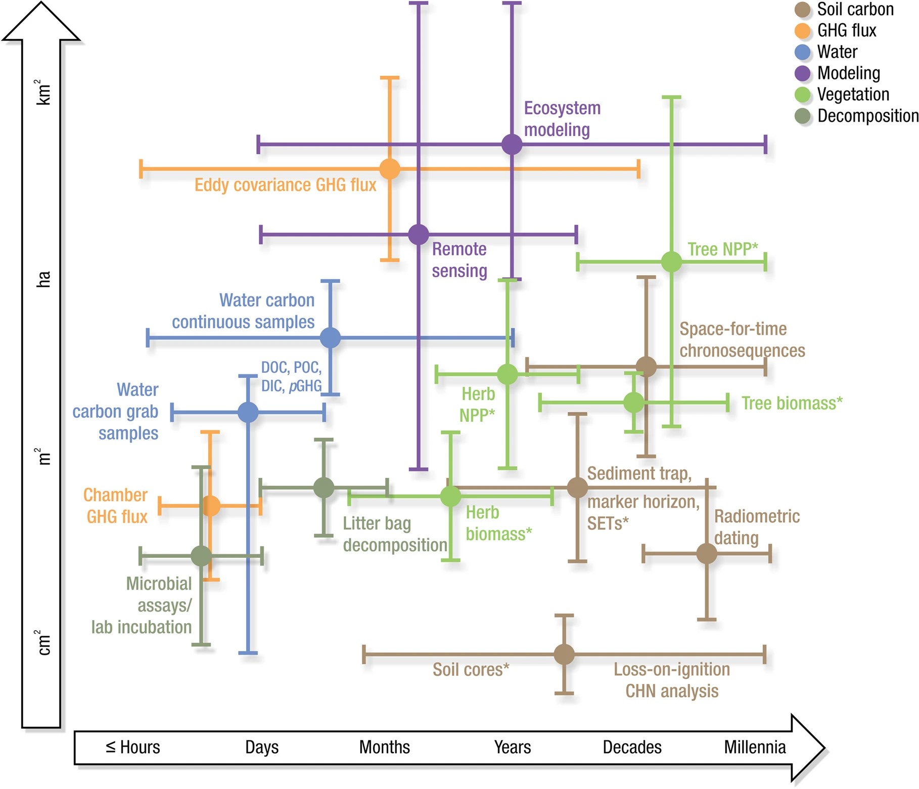
Wetlands cover a small portion of the world, but have disproportionate influence on global carbon (C) sequestration, carbon dioxide and methane emissions, and aquatic C fluxes. However, the underlying...
Resource
Authors
Shauna-Lee Chai
Amy Nixon
Scott Nielsen
Assessed 16 potentially new invasive plant species not yet present in Alberta for their invasiveness and climate change-related risk
Resource
Authors
A. Brown
M.J. Kent
J.O. Park
R.D. Roberts
3 aspects of aquatic habitat assessment and mapping. 1 - review of the parameters which characterize aquatic habitats. 2 - efficient procedure for collecting the data. 3 - computer mapping techniques
Resource
Provides recommendations based on the field survey and ground checking, for developing methodologies to enhance the detail on 1:50 000 vegetation maps (preliminary vegetation community classification)
Resource
Authors
Anthony Stewart
Meghan Halabisky
Chad Babcock
David Butman
David D’Amore
Monika Moskal
Inland wetlands are critical carbon reservoirs storing 30% of global soil organic carbon (SOC) within 6% of the land surface. However, forested regions contain SOC-rich wetlands that are not included...
Resource
Authors
Iuliia Burdun
Michel Bechtold
Valentina Sagris
Annalea Lohila
Elyn Humphreys
Ankur Desai
Mats Nilsson
Gabrielle De Lannoy
Ülo Mander
Resource Date:
September
2020
The OPtical TRApezoid Model (OPTRAM) is a physically-based approach for remote soil moisture estimation. OPTRAM is based on the response of short-wave infrared (SWIR) reflectance to vegetation water...