
Search Results
Displaying:
1 - 20 of 46
A Mesocosm‐Scale Study of Chemical and Ecological Response to Different Types of Oil Sands Tailings and Process Water (2019 ‐ 2021)
Resource
The use of pit lakes (PL) to reclaim pits at the end of mine life is common in metal and coal extraction operations. Oil sands mine operators of Canada’s Oil Sands Innovation Alliance (COSIA)...

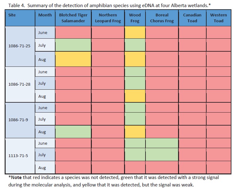
Amphibian eDNA Pilot Report
Resource
The eDNA approach detected three amphibian species across the four sites sampled in this project. Three amphibian species were identified by ARU methods at the four sites.
Carbon Dissolution Effects on pH Changes of RAMP Lakes in Northeastern Alberta, Canada
Resource
This study focuses on interpretation of hydrochemistry from 50 lakes thought to be acid sensitive, and so monitored by the Regional Aquatic Monitoring Program (RAMP) over the last two decades. This...

Certification of Mineral Soil Pads in the Boreal Region – A Path Forward. Working Session Summary
Resource
Workshop summary of discussions to inform a path forward for a policy framework that provided clarity on the process to request a change in land use and the criteria for evaluating the requests.

Certification of Mineral Soil Pads in the Boreal Region – Decision Framework and Support Tools
Resource
Factors to consider when assessing the ecological implications of a change in land use request (hydrology, cumulative effects and regional considerations, upland function, status of the borrow pit ...

Certification of Mineral Soil Pads in the Boreal Region – Decision Framework and Support Tools: 2023 Update
Resource
This 2022 Update is a revision of the original Decision Framework and Support Tools report based on stakeholder feedback and a field verification trial.

Certification Of Mineral Soil Pads in The Boreal Region – Decision Framework and Support Tools: Stakeholder Review and Field Verification
Resource
Results of a stakeholder review of the draft Certification of Mineral Soil Pads in the Boreal Region – Decision Framework and Support Tools report and a field verification trial by practitioners.

Comparison of Sampling Techniques to Monitor Stream Amphibian Communities in Forested Regions of Alberta
Resource
Objective was to compare the effectiveness of four commonly used sampling techniques (pitfall traps, funnel traps, visual searches and call surveys) to detect stream amphibian communities.

Densified Fluid Fine Tails and Oil Sands Process Water - an Extension of the 2017 Study - Final Report
Resource
A mesocosm study was undertaken to support the development of end pit lake technology. The mesocosms were exposed to OSPW (Oil Sands Process affected Water) and dFFT (densified Fluid Fine Tails).

Densified Fluid Fine Tails and Oil Sands Process Water: A Screening Study - Final Report - Study Plan Number: MES-2017-1
Resource
This study utilized mesocosms to investigate the effects of oil sands process water (OSPW) and densified fluid fine tails (dFFT) on aquatic ecosystems to support development of end pit lake technology
Evaluation of Reclamation Practices on Upland and Peatland Wellsites
Resource
Need for clear direction on information required to support professional justification which describes why specific deficiencies will not have long term adverse environmental impacts and/or affect ELC

Factors that Result in Sustainable Forest Ecosystem Development on Padded Sites in Peatlands: Pilot Study
Resource
The pilot study validated the research questions, sampling design, measurement and data analysis methods developed for a large‐scale study, with some minor amendments.

Forest Ecosystem Monitoring in Saskatchewan and Alberta: Identification of Aquatic Elements and Sampling Protocols
Resource
This chapter describes aquatic elements and sampling protocols that could be used to monitor forested stream ecosystems in Alberta and Saskatchewan

Governance as a Driver of Change in the Canadian Boreal Zone
Resource
The Canadian boreal forest is primarily public land, owned and managed by provincial governments on behalf of the public interest. Boreal forest governance consists of a complex patchwork of federal...

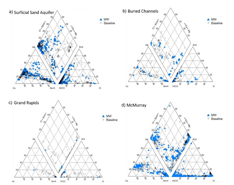
Groundwater Monitoring Near Oil Sands Development: Insights From Regional Water Quality Datasets in the Alberta Oil Sands Region (AOSR)
Resource
Groundwater quality data for the AOSR are compiled and interpreted to provide information on regional water quality to inform groundwater monitoring and land use planning. A database of 546 water...

Groundwater Monitoring Near Oil Sands Development: Insights from Regional Water Quality Datasets in the Alberta Oil Sands Region (AOSR)
Resource
Groundwater quality data for the AOSR are compiled and interpreted to provide information on regional water quality to inform groundwater monitoring and land use planning. A database of 546 water...
Guide to Variance Justifications for Reclamation Certification of Wellsites and Associated Facilities on Forested Land: Case Studies
Resource
This document provides five case studies to show how the Guide to Variance Justifications for Reclamation Certification would be applied to real‐world examples of reclamation certificate applications

Guide to Variance Justifications for Reclamation Certification of Wellsites and Associated Facilities on Forested Land
Resource
This document was developed to provide guidance and consistency in applying for and approving variance requests for reclamation certification of upland sites from an ecological perspective.

HydroGeoSim: A Water Purification Geosimulation Modelling Platform
Resource
The model documentation summarizes the data, variables and assumptions required to capture how water purification services are provided across landscapes in Alberta
