
Search Results
Displaying:
1 - 20 of 163
Syncrude's Reclamation Research Program
Resource
The objective of Syncrude's land reclamation research program is to identify and develop cost-effective land reclamation strategies and techniques to achieve acceptable reclamation for all...
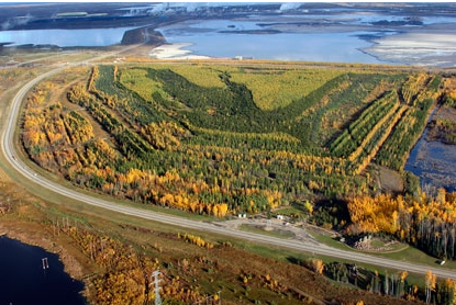
2019 Base Mine Lake Monitoring and Research Summary Report: Results from 2013-2018
Resource
Syncrude's Base Mine Lake (BML) is the first, and currently the only full-scale commercial demonstration of the end pit lake technology in the oil sands industry. An oil sands end pit lake (EPL) is an...
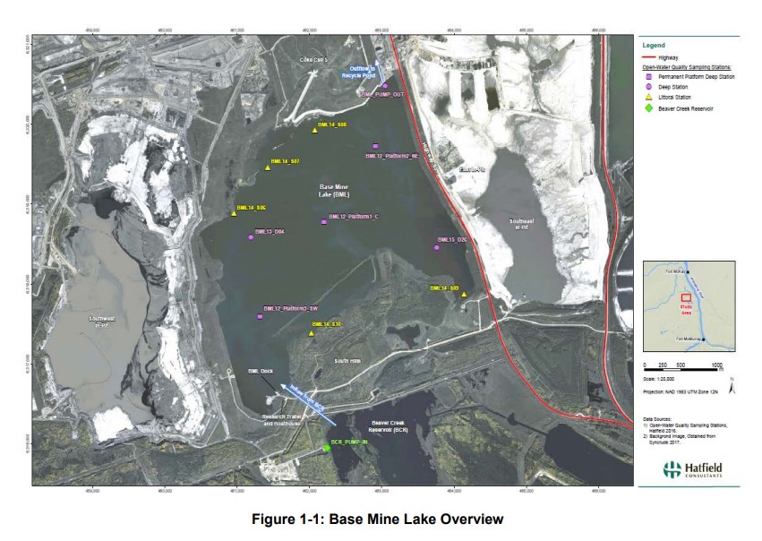
2021 Pit Lake Monitoring and Research Report
Resource
Syncrude first began investigating the Water-Capped Tailings Technology (WCTT) in the early 1980’s through the establishment of a research program founded on progressive scaled-up testing of water...

A Census of Moose on Syncrude’s Leases 17 and 22 During Early February 1977
Resource
Total numbers of moose observed and likely the total moose population, declined 40% (43 to 26) between Feb 1976 and Feb 1977. A disproportionately higher number of moose were present in aspen sites

A Study of Aquatic Environments in the Syncrude Development Area, 1984
Resource
Characterize and re-define aquatic habitats. Aquatic habitat, water quality, flora, and fauna of the aquatic systems in the development area are typical of those found in the oil sands region

A Study of Biological Colonization of the West Interceptor Ditch and Lower Beaver Creek
Resource
describe existing environmental conditions in, and to document natural biological colonization of, the West Interceptor Ditch and determine the degree of biological colonization of lower Beaver Creek

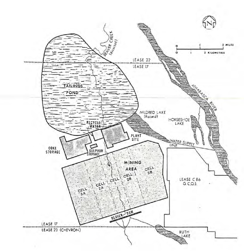
A Study of the Chemical and Physical Properties of Syncrude's Tailings Pond, Mildred Lake, 1980
Resource
In 1980, the tailings pond was a highly stratified waterbody with a low density, well mixed surface zone (0-6 m) overlying a high density deep water zone (>10 m) where mixing is slow

A Synthesis of Three Decades of Eco-Hydrological Research at Scotty Creek, NWT, Canada
Resource
Scotty Creek, Northwest Territories (NWT), Canada, has been the focus of eco-hydrological research for nearly three decades. Over this period, field and modelling studies have generated new insights...

Agronomic Properties and Reclamation Possibilities for Surface Materials on Syncrude Lease #17
Resource
Reclamation planning for tar sands mining and extraction operation differs greatly from that used in Alberta foothills and plains coal mines. One of the main differences is that the bulk of the...
Alberta Background Soil Quality System Project: Workshop Summary
Resource
Objective is to work collaboratively with soil data users to develop the Alberta Background Soil Quality System (ABSQS) as a tool to assist industry and government in environmental management

Alberta Boreal Deer Project: Final Report
Resource
White-tailed deer expansion in the boreal forest is due to an interaction between less severe winters following climate change, and a substantial forage subsidy provided by widespread anthropogenic features

Algar Habitat Project: Improving Fen Restoration Outcomes
Resource
Monitoring has been ongoing in Algar since 2011. Monitoring data along with supporting field observations information suggest that treatments may not be successfully placing linear disturbance within...

An Entomological Reconnaissance of Syncrude Lease #17 and its Environs
Resource
Entomological reconnaissance study of Syncrude Lease #17 area to gain preliminary data and to examine the potential of insects as biological monitors of environmental changes resulting from Syncrude

Analysis and Improvement of Linear Features to Increase Caribou Functional Habitat in West-central and North-western Alberta
Resource
We used GPS data from caribou and wolves, field data on human and wildlife use of seismic lines and pipelines, vegetation heights extracted from LiDAR, non-invasive fecal DNA collections, and a suite...

Assessing Peatland Restoration Success to Meet Alberta’s Peatland Reclamation Criteria
Resource
We conducted a full peatland assessment using the new criteria on a restored well pad near Peace River, Alberta. In 2012, mineral overburden was removed along with geo-textile and the buried peat was...

Assessing Spatial Factors Affecting Predation Risk to Boreal Caribou Calves: Implications for Management
Resource
In 2013, we completed the last year of data collection for the project. Across the project’s three years, we collected GPS data from 57 female caribou, 19 wolves (Canis lupus) and 19 black bears...
Assessment of Phytoremediation as an In-Situ Technique for Cleaning Oil-Contaminated Sites: Phase II Final Report
Resource
The cold climate and short growing season characteristic of the major oil and gas producing regions of western Canada make it particularly important to conduct phytoremediation research on plants...

Baseline Environmental Studies of Ruth Lake and Poplar Creek
Resource
Ruth Lake is a small, littoral, moderately eutrophic lake. Poplar Creek is a small, brownwater tributary of the Athabasca River.

Baseline Studies of Aquatic Environments in the Athabasca River Near Lease 17
Resource
The study consisted of three parts: 1) A general reconnaissance early in the study period including a survey of fish species, benthic invertebrates, periphyton (attached algae) and water quality
