The Boreal Caribou Ecological Model
Developed by the Habitat Restoration Working Group (HRWG) of the National Boreal Caribou Knowledge Consortium (NBCKC).
Habitat restoration is expected to play a key role in the recovery of boreal woodland caribou (Rangifer tarandus caribou) in Canada. Population declines are correlated with the proportion of ranges affected by anthropogenic and natural disturbances and reversing these impacts is expected to benefit caribou populations. However, there are various mechanisms that lead from habitat stressors to caribou declines, and the effects of these mechanisms differ among ranges.
Understanding the ecological pathways driving observed relationships can inform restoration planning by:
- directing treatments towards the most critical, range-specific mechanisms;
- identifying possible confounding factors that need to be addressed; and,
- supporting adaptive management by generating testable hypotheses and clarifying monitoring needs.
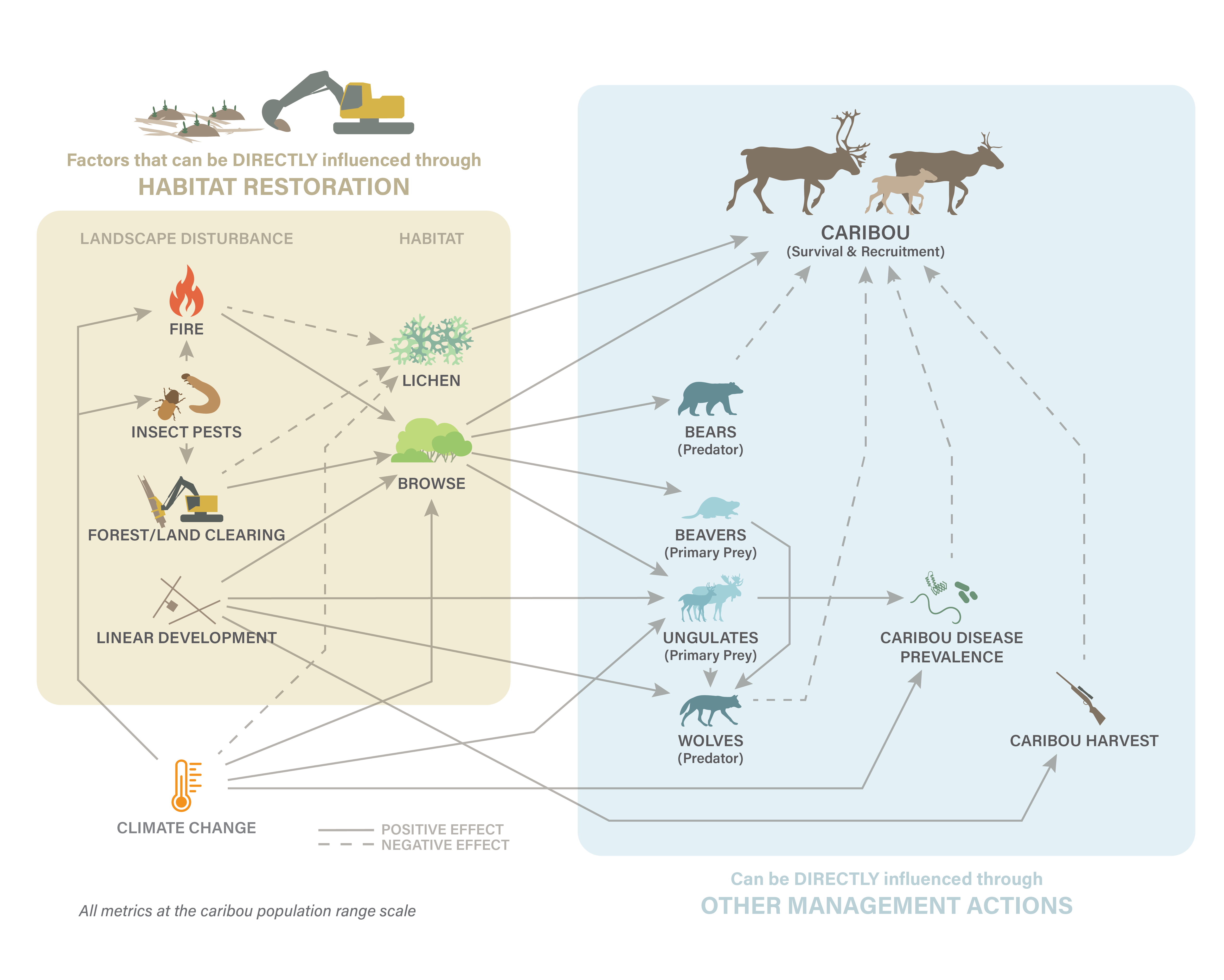
Here we present a conceptual Boreal Caribou Ecological Model developed by the Habitat Restoration Working Group of the National Boreal Caribou Knowledge Consortium. The model is composed of 14 factors and associated relationships that generate pathways leading from a variety of landscape disturbance stressors. The model does not capture all possible factors in the system, but only those that are likely exerting significant effects. Nor does it address specific restoration treatment options but it can inform the design of treatments by identifying the functional effects that treatments should be addressing.
Caribou survival and recruitment are affected directly by predation, nutrition, disease and hunting. All of these link back to one or more habitat stressors that drive the national disturbance model (i.e., fire, insect pests, forest alteration/clearing and linear development). The individual relationship pathways interact with each other and can also be affected by external factors. The habitat stressors alter forage available to caribou and to other primary prey, the distribution and abundance of primary prey, associated predators and of humans, and ultimately cause population declines via lower caribou survival and reproductive success.
A key next step for the conceptual model is the development of appropriate response metrics to monitor response to restoration efforts. This would provide the means to compare the relative effects of different drivers among ranges and would highlight key knowledge gaps. The model would then provide a complete framework for adaptive management as habitat restoration is implemented.
links to the Tools developed by the Habitat Restoration Working Group:
- The Boreal Caribou Ecological Model (current page)
To learn more about caribou habitat restoration please visit our 'Caribou Habitat Restoration' page [under development].
