Boreal Caribou Search Results
Resource
Welcome to MarshWatch! MarshWatch is a new pilot program focused on wetland birds and amphibians for beginners. Virtual webinars along with self-guided activities slowly build your identification...
Resource
Authors
Shijuan Chen
Gregory McDermid
Guillermo Castilla
Julia Linke
Resource Date:
December
2017
Monitoring vegetation recovery typically requires ground measurements of vegetation height, which is labor-intensive and time-consuming. Recently, unmanned aerial vehicles (UAVs) have shown great...
Resource
Authors
Mighty Peace Watershed Alliance
The Mighty Peace Watershed Alliance (MPWA) supports the three goals of Alberta’s Water for Life Strategy: safe secure drinking water, healthy aquatic ecosystems, and reliable, quality water supplies...
Resource
Comprehensive assessment of mixing characteristics of the Athabasca River below Fort McMurray under ice-covered flow conditions. Two tracer tests conducted and analysed using recent theoretical models
Resource
Potential for using satellite imagery to determine water quality parameters in the southwest end of Lake Athabasca and provide a mathematical model capable of simulating the circulation patterns
Resource
Authors
Ken Foster
Christine Godwin
Peter Pyle
The MAPS protocol (Monitoring Avian Productivity and Survivorship) was applied in a 2011 pilot program in the boreal forest in the oil sands region
Resource
Authors
Anne McIntosh
Bonnie Drozdowski
Dani Degenhardt
Chris Powter
Christina Small
John Begg
Dan Farr
Arnold Janz
Randi Lupardus
Delinda Ryerson
Jim Schiek
We developed a scientifically robust and financially sustainable monitoring protocol to enable a consistent assessment of ecological recovery at reclaimed industrial wellsites in forested lands
Resource
Authors
Nadia Rochdi
J. Zhang
Karl Staenz
X. Yang
D. Rolfson
J. Banting
C. King
R. Doherty
Scope of the project is to develop a geomatics-based monitoring system to support the Government of Alberta’s efforts for monitoring reclamation success. Software will support decision making process
Resource
Authors
Megan Hornseth
Karine Pigeon
Doug MacNearney
Terrence Larsen
Gordon Stenhouse
Jerome Cranston
Laura Finnegan
Natural regeneration of seismic lines, cleared for hydrocarbon exploration, is slow and often hindered by vegetation damage, soil compaction, and motorized human activity. There is an extensive...
Resource
Authors
Andrew Latham
Maria Latham
Mark Boyce
Stan Boutin
Resource Date:
December
2011
This resource is available on an external database and may require a paid subscription to access it. It is included on the CCLM to support our goal of capturing and sharing the breadth of all...
Resource
Authors
Christopher Beirne
Catherine Sun
Erin Tattersall
Joanna Burgar
Jason Fisher
Cole Burton
This resource is available on an external database and may require a paid subscription to access it. It is included on the CCLM to support our goal of capturing and sharing the breadth of all...
Resource
In most years, evaporation exceeds summer rainfall. Using natural aspen stands as a comparison, it is expected that water use from the soil cover will continue to increase as the ecosystem ages.
Resource
Authors
National Tree Seed Centre
This webinar presented by the National Tree Seed Centre focuses on tree and shrub species that produce seed in the autumn and how to predict if they will produce a good seed crop. Species discussed...
Resource
Authors
Cassidy van Rensen
Scott Nielsena
Barry White
Tim Vinge
Victor Lieffers
Mapping of oil reserves involves the use of seismic lines (linear disturbances) to determine both their location and extent. Conventional clearing techniques for seismic assessment have left a legacy...
Resource
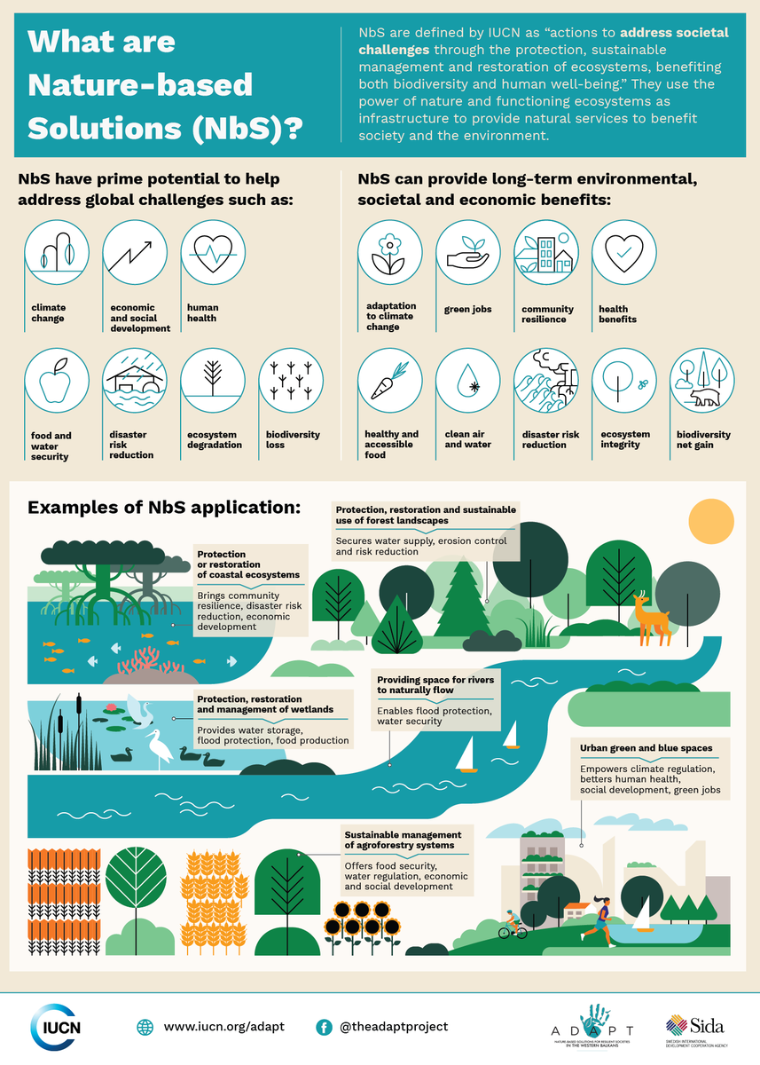
Nature-based Solutions leverage nature and the power of healthy ecosystems to protect people, optimise infrastructure and safeguard a stable and biodiverse future. Explore topics related to Nature...
Resource
Authors
Wetland Knowledge Exchange
Resource Date:
November
2023
Cassandra Chabot-Madlung, County of Grande Prairie presents - Wetland Replacement Program: How it Started & Who Can Participate This is a Municipal viewpoint of Alberta Environment and Protected Areas...
Resource
Authors
Richard Johnson
P. Bork
E.A.D. Allen
W.H. James
L. Koverny
The experiments detailed in this report show that it was possible to increase the solids content of sludge to 50% solids by adding three parts sand (tailings sand) to one part sludge.
Resource
Authors
Craig Mahoney
Joshua Montgomery
Stephanie Connor
Danielle Cobbaert
Abstract Boreal wetlands within the oil sands region of Alberta, Canada, are subject to natural and anthropogenic pressures, resulting in the need for monitoring these sensitive ecosystems to ensure...
Resource
Authors
Gabriela Siles
Yves Voirin
Goze Bertin Bénié
Resource Date:
January
2018
This resource is available on an external database and may require a paid subscription to access it. It is included on the CCLM to support our goal of capturing and sharing the breadth of all...
Resource
Authors
Hedwig Lankau
Erin Bayne
Craig Machtans
The boreal forest of western Canada is being dissected by seismic lines used for oil and gas exploration. The vast amount of edge being created is leading to concerns that core habitat will be reduced...