Land Management Search Results
Resource
Authors
Chris Powter
Natalie Shelby-James
Bin Xu
Kevin Renkema
Results of a stakeholder review of the draft Certification of Mineral Soil Pads in the Boreal Region – Decision Framework and Support Tools report and a field verification trial by practitioners.
Resource
Authors
Daniel Peters
Dillon Watt
Kevin Devito
Wendy Monk
Rajesh Shrestha
Donald Baird
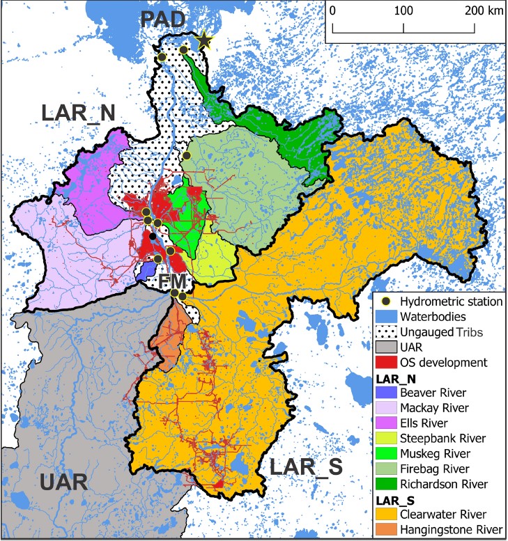
The goal of this study is to enhance the understanding of the regional role of the lower Athabasca Basin areas in overall runoff delivery to the downstream Peace-Athabasca Delta. The Cold-regions...
Resource
Authors
Matthew Elmes
Richard Petrone
O. Volik
Jonathan Price
We assessed the hydrological changes to the hydrology of a moderate-rich fen after the construction of a road (perpendicular to flow) in 2003 and a pipeline (obliquely to flow) in 2011. New...
Resource
Organic constituents of wastewaters discharged from the GCOS plant and Syncrude Canada Ltd. lease No. 17 were characterized and compared to those occurring naturally in the Athabasca River
Resource
This thesis is comprising two studies characterizing nutrient dynamics within the Athabasca Oil Sands region (AOS) of Alberta. The first study simultaneously examined and compared nutrient (nitrogen...
Resource
Authors
Jean Birks
Yi Yi
Sunny Cho
Emily Taylor
John Gibson
This study was conducted to characterize the composition of polar dissolved organic compounds present in snow and surface waters in the Athabasca Oil Sands Region (AOSR) with the goal of identifying...
Resource
Authors
Jean Birks
Yi Yi
Sunny Cho
John Gibson
Rod Hazewinkel
Goal was identifying whether atmospherically-derived organics present in snow are a significant contributor to the organics detected in rivers and lakes in the oil sands region
Resource
Authors
D.W. Mayhood
Linda Corkum
Baseline data available on the Muskeg River hydrology, benthic invertebrates, plankton and fish are generally useful, but additional information is desireable
Resource
Authors
D.W. Mayhood
Gerry Walder
Tom Dickson
R.B. Green
Dave Reid
R. Strushnoff
Studies intended to both monitor the effects of Alsands' muskeg drainage on aquatic habitats and terrestrial vegetation, and to form the basis of a long-term aquatic habitat monitoring program
Resource
The present volume evaluates the 1980 monitoring program, and makes suggestions for the conduct of future monitoring studies on the Muskeg River and elsewhere in the AOSERP area
Resource
Authors
C.R. Neill
B.J. Evans
A.W. Lipsett
Describe how water and sediment from the Athabasca River are distributed through the delta system and how they circulate and mix in Lake Athabasca and flow through to the Slave River (re contaminants)
Resource
Authors
Mariusz Gałka
Andrei-Cosmin Diaconu
Anna Cwanek
Lars Hedenäs
Klaus-Holger Knorr
Piotr Kołaczek
Edyta Łokas
Milena Obremska
Graeme Swindles
Angelica Feurdean
Rapidly increasing temperatures in high-latitude regions are causing major changes in wetland ecosystems. To assess the impact of concomitant hydroclimatic fluctuations, mineral deposition, and...
Resource
Authors
Alberta Environment and Parks
This code of practice regulates wetland restoration and wetland construction activities as defined in the Code by replacing Water Act approval requirements. Wetland restoration is applied to wetlands...
Resource
Authors
N. Moudrak
B. Feltmate
H. Venema
H. Osman
Resource Date:
September
2018
Combating Canada’s Rising Flood Costs: Natural infrastructure is an underutilized option.
Resource
Authors
Chris Powter
Brent Scorfield
Brent Lakeman
Shane Patterson
The development of integrated geomatics and remote sensing technologies for environmental management holds promise to meet economic diversification and effective environmental management.
Resource
Objective of the project was to better understand and describe the potential for CLPP to provide meaningful assessments of aquatic ecosystems in the oil sands region of Alberta to various stakeholders
Resource
Authors
Evan DeLancey
John Simms
Masoud Mahdianpari
Brian Brisco
Craig Mahoney
Jahan Kariyeva
Developed two wetland inventory style products for a large (397,958 km2) area in the Boreal Forest region of Alberta, Canada, using Sentinel-1, Sentinel-2, and ALOS DEM data
Resource
Authors
Lauren Thompson
M. Low
Renae Shewan
Christopher Schulze
M. Simba
Oliver Sonnentag
Suzanne Tank
David Olefeldt
Boreal rivers deliver dissolved organic carbon (DOC), mercury (Hg), and its neurotoxic form, methylmercury (MeHg), from contributing landscapes to downstream waters. In northern regions, thawing...
Resource
Scenarios of expected concurrent flow along the Athabasca River are developed on the assumption that a 7Q10 event occurs at either Hinton, Whitecourt, Athabasca, or Fort McMurray
Resource
Authors
Jody Daniel
Rebecca Rooney
The hydroperiod (i.e., the length of time ponded water is present) of prairie potholes is sensitive to climate change. Because snowmelt runoff is the largest contributor to ponded water amounts, a...