Land Management Search Results
Resource
Authors
Paul Pickell
David Andison
Nicholas Coops
This resource is available on an external database and may require a paid subscription to access it. It is included on the CCLM to support our goal of capturing and sharing the breadth of all...
Resource
Authors
Alex Schumacher
Reinhard Hermesh
Antoine Bedwany
The study involved an examination of the vegetation and spoils on five mine locations in the central Parkland of Alberta. These five locations represented different spoil types, and methods of mining...
Resource
In regard to reclamation, the predisturbance inventories carried out as a function of the EIA or D&R Approval, dictate to a large extent the vegetation cover or land uses that will be established. As...
Resource
Authors
Chris Powter
Brent Scorfield
Brent Lakeman
Shane Patterson
The development of integrated geomatics and remote sensing technologies for environmental management holds promise to meet economic diversification and effective environmental management.
Resource
Authors
Terry Macyk
Bonnie Drozdowski
This report identifies and summarizes reclamation practices that have been used in the mineable Oil Sands region and coal mining industry over the last 40+ years.
Resource
Studies were continued in 1976 into the improvement of a five year old revegetated area on a tailings sand dike by the implementation of different fertilizer programs.
Resource
Resource Date:
April
2015
This document combines as-of-2014 reports for projects relating to mine site reclamation of the Canada’s Oil Sands Innovation Alliance (COSIA) Land Environmental Priority Area (EPA). These include...
Resource
Resource Date:
April
2017
This document combines as-of-2016 reports for projects relating to mine site reclamation of the Canada’s Oil Sands Innovation Alliance (COSIA) Land Environmental Priority Area (EPA). These research...
Resource
Resource Date:
April
2021
This document combines reports, as of 2020, for projects relating to mine site reclamation of the Canada’s Oil Sands Innovation Alliance (COSIA) Land Environmental Priority Area (EPA). These research...
Resource
Authors
Alberta Centre for Reclamation and Restoration Ecology
Oil Sands Research and Information Network
One of the core mandates for the Oil Sands Research and Information Network (OSRIN) was to enhance access to oil sands environmental management information. With OSRIN’s mandate ending December 31...
Resource
Authors
NAIT Centre for Boreal Research
The Decision Support Systems (DSS) uses a scenario approach to guiding reclamation and restoration activities. This resource follows the Vegetation Treatment Process for Forest Land (Upland). DSS are...
Resource
The deeper soil salvage depth (40 cm) was better than the shallow salvage depth (15 cm) at establishing a forest understory plant community characteristic of the boreal forest.
Resource
Three mid- to high-elevation lines of slender wheatgrass were selected and released as varieties for use in reclamation
Resource
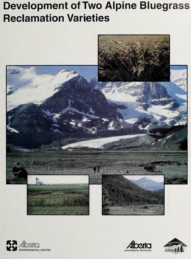
Two lines of alpine bluegrass were selected and released as varieties for use in reclamation
Resource
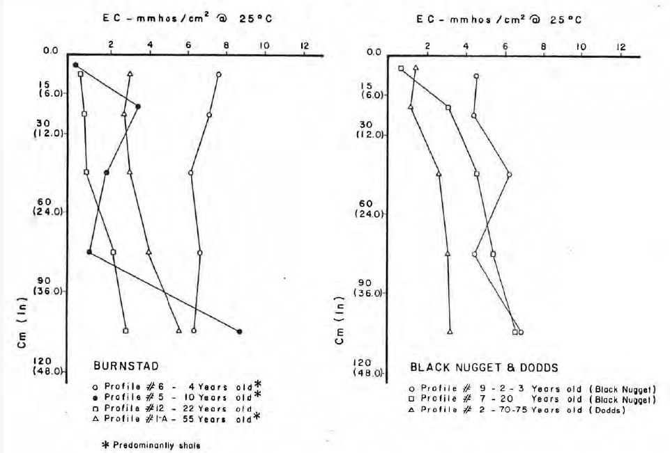
Soils sampled at sites 2.3 and 5.3 km south of the Great Canadian Oil Sands (GCOS) plant, Fort McMurray, respectively were found to differ statistically with reference to several macronutrients
Resource
Stem cuttings of balsam poplar and three poplar hybrids were directly planted onto reclamation material ontailings dyke slope. The overall rooting success was poor - direct planting is not recommended
Resource
The trial was established on blended materials consisting of native sand, clayey overburden and peat. Nine native grasses and eight cultivated grass varieties were seeded in June of 1981.
Resource
Authors
Roger DeAbreu
Shane Patterson
Todd Shipman
Chris Powter
NRCan pilot science projects have proven that Earth Observation can provide relevant and valuable information to inform and enhance monitoring and support regulatory frameworks
Resource
There was only very limited evidence of biological responses to increased pollutant content in spite of significantly higher pollutant levels in tissues close to existing industrial developments.
Resource
Authors
M.D. Thompson
M.C. Wride
M.E. Kirby
Classification system devised for mapping vegetation and surficial geology from 1:60,000 scale false colour infrared photographs; 1:50 000 base maps plus a vegetation and a surficial geology overlay