Land Management Search Results
Resource
Authors
Humaira Enayetullah
Laura Chasmer
Chris Hopkinson
Daniel Thompson
Danielle Cobbaert
Seismic lines are the dominant anthropogenic disturbance in the boreal forest of the Canadian province of Alberta, fragmenting over 1900 km 2 of peatland areas and accounting for more than 80% of all...
Resource
Authors
Chris Stockdale
Quinn Barber
Amit Saxena
Marc-Andre Parisien
Resource Date:
March
2019
We undertook a wildfire risk assessment across the Cold Lake caribou range where we used the Burn-P3 model to determine: a) burn probability; b) wildfire risk to restored seismic line areas; and c) the effectiveness of mitigation measures. The burn probability of the landscape was highly heterogeneous, and recent large burns and some waterbodies provided “shields” that reduced burn probability on their leeward sides.
Resource
Authors
Melanie Dickie
Robert Serrouya
Scott McNay
Stan Boutin
Predation by grey wolves Canis lupus has been identified as an important cause of boreal woodland caribou Rangifer tarandus caribou mortality, and it has been hypothesized that wolf use of human...
Resource
Authors
Jean Birks
John Manchuk
Yi Yi
Cynthia McClain
Michael Moncur
John Gibson
Clayton Deutsch
Emily Taylor
Guy Bayegnak
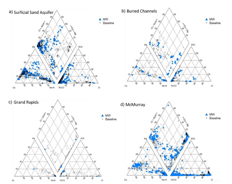
Groundwater quality data for the AOSR are compiled and interpreted to provide information on regional water quality to inform groundwater monitoring and land use planning. A database of 546 water...
Resource
Authors
Jean Birks
John Manchuk
Yi Yi
Cynthia McClain
Michael Moncur
John Gibson
Clayton Deutsch
Emily Taylor
Guy Bayegnak
Groundwater quality data for the AOSR are compiled and interpreted to provide information on regional water quality to inform groundwater monitoring and land use planning. A database of 546 water...
Resource
Authors
Cynthia Dacre
David Palandro
Anna Oldak
Alex Ireland
Sean Mercer
Project demonstrated that high-spatial-resolution satellite imagery could be used to develop accurate land-cover classifications on reclaimed in-situ operations
Resource
Authors
Kelly Biagi
Graham Clark
Sean Carey
Resource Date:
August
2021
This resource is available on an external database and may require a paid subscription to access it. It is included on the CCLM to support our goal of capturing and sharing the breadth of all...
Resource
Authors
Tyler Muhly
Robert Serrouya
Eric Neilson
Haitao Li
Stan Boutin
Predictions demonstrate that maintaining permeability across In-situ oil sands development is more important than spacing between leases or including protected areas.
Resource
Authors
Sini-Selina Salko
Jussi Juola
Iuliia Burdun
Harri Vasander
Miina Rautiainen
Boreal peatlands store ~25 % of global soil organic carbon and host many endangered species; however, they face degradation due to climate change and anthropogenic drainage. In boreal peatlands...
Resource
Authors
Cari Ficken
Danielle Cobbaert
Rebecca Rooney
Resource Date:
November
2019
Boreal wetlands are at risk of degradation from anthropogenic activities including oil sands energy extraction. Despite efforts to monitor the impacts of oil sands energy extraction-related activities...
Resource
Authors
Angelo Filicetti
Jesse Tigner
Scott Nielsen
Katherine Wolfenden
Murdoch Taylor
Paula Benthamd
Resource Date:
November
2023
Seismic lines, linear features originating from the oil and gas industry for energy exploration, pose a substantial management challenge due to their collective impact on biogeochemical cycles, plant...
Resource
Authors
Harry Spaling
Janelle Zwier
William Ross
Roger Creasey
This resource is available on an external database and may require a paid subscription to access it. It is included on the CCLM to support our goal of capturing and sharing the breadth of all...
Resource
Authors
Anne McIntosh
Bonnie Drozdowski
Dani Degenhardt
Chris Powter
Christina Small
John Begg
Dan Farr
Arnold Janz
Randi Lupardus
Delinda Ryerson
Jim Schiek
We developed a scientifically robust and financially sustainable monitoring protocol to enable a consistent assessment of ecological recovery at reclaimed industrial wellsites in forested lands
Resource
Authors
Andrew Latham
Maria Latham
Mark Boyce
Stan Boutin
Resource Date:
December
2011
This resource is available on an external database and may require a paid subscription to access it. It is included on the CCLM to support our goal of capturing and sharing the breadth of all...
Resource
Authors
Cassidy van Rensen
Scott Nielsena
Barry White
Tim Vinge
Victor Lieffers
Mapping of oil reserves involves the use of seismic lines (linear disturbances) to determine both their location and extent. Conventional clearing techniques for seismic assessment have left a legacy...
Resource
Authors
Craig Mahoney
Joshua Montgomery
Stephanie Connor
Danielle Cobbaert
Abstract Boreal wetlands within the oil sands region of Alberta, Canada, are subject to natural and anthropogenic pressures, resulting in the need for monitoring these sensitive ecosystems to ensure...
Resource
Authors
Hedwig Lankau
Erin Bayne
Craig Machtans
The boreal forest of western Canada is being dissected by seismic lines used for oil and gas exploration. The vast amount of edge being created is leading to concerns that core habitat will be reduced...
Resource
Authors
Chantel Markle
Paul Moore
Mike Waddington
Identifying ecosystems resilient to climate and land-use changes is recognized as essential for conservation strategies. However, wetland ecosystems may respond differently to stressors depending on...
Resource
Authors
Brittany Flemming
Vincent Futoransky
Wade Pruett
This resource is available on an external database and may require a paid subscription to access it. It is included on the CCLM to support our goal of capturing and sharing the breadth of all...
Resource
Authors
Terry Macyk
Martin Fung
Ron Pauls
Syncrude Canada Ltd. produces 200,000 barrels of synthetic crude oil per day from its oil sands surface mining operations located 50 km north of Fort McMurray, Alberta. The three major types of...