Land Management Search Results
Resource
Uranium mining in the Athabasca Basin region in Northern Saskatchewan was developed in the early 1950s. The mines developed during this period were abandoned, leaving deep holes and mining debris...
Resource
Authors
Dianne Allen
Mark Calette
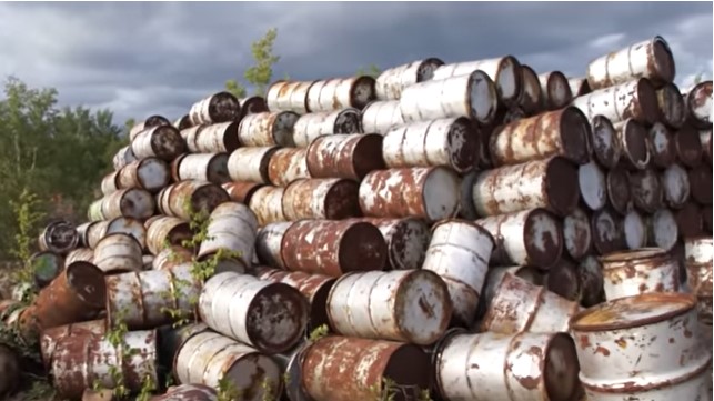
In 1960, the Lorado Mill was abandoned in northern Saskatchewan, leaving an estimated 227,000 cubic meters of radioactive uranium tailings that covered the mill site and flowed into nearby Nero Lake...
Resource
Dr. Frank Larnery compares soils and crop management in Akmola province, Kazakhstan with cropping in the black soil zone of Alberta.
Resource
This presentation discusses conservation offsets such as wetland replacement. It is a tool to address multiple demands on land, air and watersheds.
Resource
This presentation is about understanding how land disturbances impact the diversity, abundance and activity of soil microorganisms, and discusses both CLPP and functional diversity
Resource
At the 2013 Alberta Soil Science Workshop, Dr. Jim Miller covered the extensive and long term results of riparian protection (streambank fencing and offsite watering for cattle pastures) on stream water quality and biology plus the benefits and costs for cattleman.
Resource
This presentation is about an evaluation of nutrient and irrigation management Beneficial Management Practices (BMPs) in Southern Alberta.
Resource
Sascha Bachmann presented research related to reclamation of temporary drilling pads.
Resource
Authors
Alexey Klyashtorin
Tamara Yankovich
The Gunnar Mine site is part of a cleanup project, Project CLEANS (Cleanup of Abandoned Northern Sites), managed by the Saskatchewan Research Council (SRC). Significant progress was made at Gunnar...
Resource
Dr. Roland Kroebel outines where ecosystem modeling for agriculture is moving in a presentation to the 50th Alberta Soil Science Workshop. Starting with a GHG calculator, HOLOS, Dr. Kroebel proposes adding a number of other models, for carbon, soil moisture, nitrogen and environmental footprints to create a "Virtual Farm" concept.
Resource
Authors
NAIT Centre for Boreal Research
NAIT Centre for Boreal Research (formerly NAIT Boreal Research Institute) is developing cost effective methods to restore the ecological functions of the decommissioned wellsites with the surrounding...
Resource
Authors
NAIT Centre for Boreal Research
This video shows how to properly use the RipPlow to adjust severely disturbed soil. The NAIT Boreal Research Institute in Peace River is using the RipPlow® to test the restoration of soil quality on...
Resource
Authors
NAIT Centre for Boreal Research
Resource Date:
April
2020
Exploration of resources (i.e. oil and gas, forestry) creates numerous temporary access features, including seismic lines, winter roads, and oil sands exploration (OSE) wells in boreal peatlands...
Resource
Authors
Anne Naeth
Konstantin Dlusskiy
Leonard Leskiw
Chris Powter
Andy Etmanski
Humans impact everything, including our soil. We remove, mix and compact soil horizons. We add amendments, including waste materials, to replace soil or improve its health. Soils that that have been...
Resource
This presentation discusses managing soil carbon in temperate and boreal ecosystems.
Resource
I will introduce ABMI’s Ecological Recovery Monitoring program, which is establishing long-term monitoring protocols to assess ecological recovery at certified reclaimed wellsites across Alberta
Resource
Gerald Ontkean provides a history of the science of assessing soils for irrigation suitability from 1915 with the enactment of Alberta's Irrigation Act.
Resource
Amanada Schoonmaker, NAIT Boreal Research Institute, introduces a preliminary case study on ripping trials on logged landing sites and wellsite reclamation sites in NW Alberta. Soil compaction is an issue for reclamation success for both types of industrial sites.
Resource
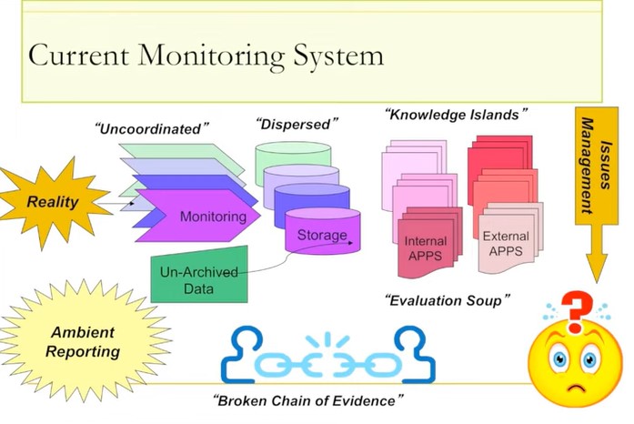
Ernie Hui gave a keynote address at the CWRA-WPAC joint conference on March 13, 2013. Ernie Hui is the CEO, Environmental Monitoring, for Alberta Environment and Sustainable Resource Development. The...
Resource
Becky Doherty summarizes the role of remote sensing can play in monitoring the progress of reclamation on mining and well sites. She outlines the techniques that can be combined to monitor changes on reclaimed sites.