Land Management Search Results
Resource
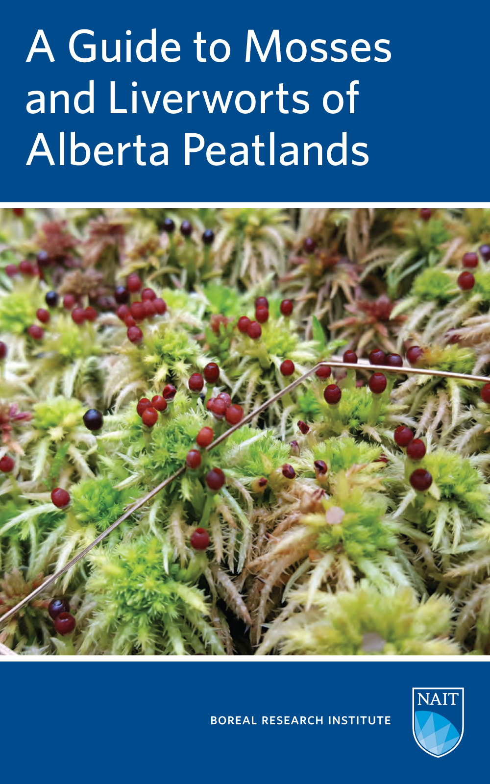
The guide identifies 60 species of mosses and liverworts that comprise the flora of fens and bogs in Alberta and western boreal Canada, designed for use in the field and laboratory.
Resource
Authors
Barbara Darroch
Surya Acharya
AEC Blueridge alpine bluegrass (Poa alpina L.) is a reclamation variety developed for use in reclaiming and revegetating disturbed sites at high elevations. It is the first variety of alpine bluegrass...
Resource
Authors
Greg McDermid
Julie Lovitt
Mustafizur Rahman
Maria Strack
Saru Saraswati
Bin Xu
This presentation discusses remote sensing to assess groundwater, microtopogpraphy and above-ground biomass, as well as wetland management. Presented at the NAIT 7th Seminar on Linear Disturbance...
Resource
Resource Date:
January
2016
This presentation provides an overview of the Ducks Unlimited Canada Enhanced Wetland Classification System, including current and potential uses for wetland conservation and management.
Resource
Authors
Erin Mallon
Merritt Turetsky
Ian Thompson
John Fryxell
Philip Wiebe
Boreal forest development is influenced by both natural and anthropogenic disturbances that alter stand structure and nutrient cycling over decadal timescales. The effects of disturbance on boreal...
Resource
The Galena Hill Ecosystem Map (GHEM) was initially developed to provide information about existing plant communities and their growth conditions to guide upcoming reclamation efforts at the historical...
Resource
Authors
Dominique Boucher
Sylvie Gauthier
Nelson Thiffault
William Marchand
Martin Girardin
Climate change is projected to increase fire severity and frequency in the boreal forest, but it could also directly affect post-fire recruitment processes by impacting seed production, germination...
Resource
Authors
S. Konkolics
Melanie Dickie
Robert Serrouya
Stan Boutin
To examine the effects of forest fires on woodland caribou, we collected GPS location data on five caribou ranges in northeastern Alberta.
Resource
Authors
Patrick Walsh
Trevor Goward
Understanding the recovery rate of overgrazed lichen communities has value to mangers of lands in northern regions. We describe lichen community composition and present recovery rate measurements for...
Resource
Authors
Alberta Biodiversity Monitoring Institute
Boreal caribou populations are declining across Alberta and much of their Canadian range. Key factors causing this decline include a warming climate along with habitat change from industrial...
Resource
Authors
Alberta Biodiversity Monitoring Institute
Seismic lines and other linear features created by humans are thought to negatively impact woodland caribou. It is estimated that there are c. 100,000 km of conventional seismic lines in caribou...
Resource
Authors
Alberta Biodiversity Monitoring Institute
Resource Date:
January
2020
Linear features, including seismic lines, pipelines, transmission lines, roads, railways, and trails are pervasive in Alberta’s boreal forest and have been implicated as a primary factor leading to...
Resource
Authors
Hans Skatter
John Kansas
Michael Charlebois
Brady Balicki
Resource Date:
February
2014
In boreal forests, wildfire is a dominant ecological process that affects the distribution and abundance of terrestrial lichens, the principal winter food for Woodland Caribou ( Rangifer tarandus...
Resource
Authors
Mar Martinez
Gary Borstad
Leslie Brown
Kaan Ersahin
Michael Henley
Monitoring of reclaimed sites is a complex, interdisciplinary undertaking, especially in large, disturbed areas with difficult access. In that context, remote sensing is a unique and valuable tool...
Resource
Authors
Ryan O’Neill
Rielle Massey-Leclerc
Jean-Marie Sobze
Katie Bartman
Catherine Brown
Resource Date:
November
2020
This note describes detailed identification of Canada Buffaloberry and technique for collecting and processing Buffaloberry seed.
Resource
Authors
Steven Wilson
Glenn Sutherland
Nicholas Larter
Allicia Kelly
Ashley McLaren
James Hodson
Troy Hegel
Robin Steenweg
Dave Hervieux
Thomas Nudds
Understanding spatial distributions of organisms and the consequences for conservation policy and management decisions remain important challenges. We describe a method for grouping caribou into plausible candidate Local Population Units that may better approximate geographic closure than the existing LPUs.
Resource
Authors
Guillermo Castilla
Ronald Hall
Rob Skakun
Michelle Filiatrault
André Beaudoin
Michael Gartrell
Lisa Smith
Kathleen Groenewegen
Chris Hopkinson
Jurjen van der Sluijs
Resource Date:
February
2022
Wall-to-wall 30 m raster maps of broad forest type, stand height, crown closure, stand volume, total volume, aboveground biomass, and stand age were created for a ~400,000 km2 area, validated with independent data, and generalized into a polygon GIS layer resembling a traditional FI map. The MVI project showed that a reasonably accurate FI map for large, remote, predominantly non-inventoried boreal regions can be obtained at a low cost by combining limited field data with remote sensing data from multiple sources.
Resource
Authors
Michael Merchant
Alain Richard
Kevin Smith
Rebecca Warren
Rebecca Edwards
Adam Spitzig
Dan Fehringer
This research poster describes the Enhanced Wetland Inventory (EWC) and Boreal Wetland Classification System developed by Ducks Unlimited Canada. Presented at the NAIT 7th Seminar on Linear...