Land Management Search Results
Resource
Authors
Alberta Biodiversity Monitoring Institute
As of 2015, 29.2% of Alberta is under human footprint, up from 25.7% in 1999—that’s an average increase of about 0.22%, or around 1450 km2 (560 sections) per year.
Resource
Authors
R.B. Caton
C.S. Davis
Martin Davies
D.L.M. Stevens
Ron Wallace
Tony Yarranton
Reid Crowther
The result of this review was a plan for a five-year biophysical monitoring program to provide the necessary scientific and technical information upon which to base an effective regulatory approach.
Resource
Authors
Leila Taheriazad
Carlos Portillo-Quintero
Arturo Sanchez-Azofeifa
This report presents a comprehensive review of industrial applications of an emerging environmental monitoring technology called Wireless Sensor Networks (WSN) and a WSN installed at Coal Valley Mine
Resource
No measureable air pollutant effect was observed on either vascular or lichen communities at any site even though significantly high tissue pollutant concentrations were documented within 10km of GCOS
Resource
Resource Date:
August
2021
With the support of Alberta Environment and Parks, the Alberta Biodiversity Monitoring Institute has become the trusted source for data about habitat, species, and the human footprint.
Resource
As caribou habitat restoration initiatives have become more widespread across Alberta in the last decade, key uncertainties have been recognized regarding what treatment types are appropriate for...
Resource
Authors
Chris Powter
Brent Scorfield
Brent Lakeman
Shane Patterson
The development of integrated geomatics and remote sensing technologies for environmental management holds promise to meet economic diversification and effective environmental management.
Resource
Long-term monitoring of some sites would ultimately be needed to show that recovering wellsites are on a trajectory that consistently leads to full recovery.
Resource
Authors
Roger DeAbreu
Shane Patterson
Todd Shipman
Chris Powter
NRCan pilot science projects have proven that Earth Observation can provide relevant and valuable information to inform and enhance monitoring and support regulatory frameworks
Resource
There was only very limited evidence of biological responses to increased pollutant content in spite of significantly higher pollutant levels in tissues close to existing industrial developments.
Resource
Authors
ERMP Project Advisory Group
Monitoring protocols for forested land wellsites to determine if a reclaimed site has returned to similar structure and function as found in a representative undisturbed reference area.
Resource
Authors
Alberta Biodiversity Monitoring Institute
Three workshops were held to examine a suite of vegetation, soil, and habitat indicators that could potentially be used to monitor recovery in a long-term reclamation monitoring program
Resource
Authors
ERMP Project Advisory Group
This report provides the monitoring protocols for cultivated land wellsites.
Resource
Authors
ERMP Project Advisory Group
This report provides the monitoring protocols for forested land wellsites.
Resource
Authors
ERMP Project Advisory Group
The Ecological Recovery Monitoring Program should be implemented in stages to allow for incorporation of learnings and additional research to support design of protocols for new disturbance types.
Resource
Authors
ERMP Project Advisory Group
This report describes several specialized monitoring techniques that were evaluated during the Ecological Recovery Monitoring Program Pilot.
Resource
Authors
Erin Bayne
Hedwig Lankau
Jesse Tigner
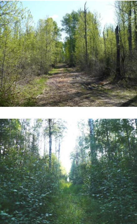
We conducted a series of surveys to evaluate wildlife responses to different types of seismic lines in bogs, conifer‐dominated, mixedwood and deciduous forests in the western boreal forest. Research...
Resource
Authors
Angelo Filicetti
Scott Nielsen
Energy exploration has led to fragmentation of habitats worldwide. In boreal forests of Alberta, Canada narrow clear-cut linear disturbances (3–14 m wide) called seismic lines are often the largest...
Resource
Authors
George LaRoi
Mike Ostafichuk
16 undisturbed, 5-ha, permanent plots dominated by Pinus banksiana (jack pine) were established along an impingement gradient of atmospheric emissions from oil sands processing plants
Resource
Authors
Oumer Ahmed
Adam Shemrock
Dominique Chabot
Chris Dillon
Griffin Williams
Rachel Wasson
Steven Franklin
Resource Date:
February
2017
This resource is available on an external database and may require a paid subscription to access it. It is included on the CCLM to support our goal of capturing and sharing the breadth of all...