Land Management Search Results
Resource
Authors
Dennis Cook
Jerald Jacobson
Study designed to develop an analysis model which would produce statistically reliable estimates of visibility bias and total population
Resource
Authors
Erin Bayne
Diana Stralberg
Amy Nixon
Use of ABMI samples to understand genetic variation and changes in genetic structure is identified as an area where ABMI data can be used to understand how biodiversity is adapting to climate change
Resource
Authors
Natalie Shelby-James
Sarah Thacker
Chris Powter
Paul Fuellbrandt
Tomislav Hengl
Leandro Parente
Objective is to work collaboratively with soil data users to develop the Alberta Background Soil Quality System (ABSQS) as a tool to assist industry and government in environmental management
Resource
The Natural Regions and Subregions classification represents the state-of-the-art in ecological land classification in Alberta. This classification provides a valuable baseline for resource management...
Resource
Authors
Alberta Forestry, Lands and Wildlife, Resource Planning Branch
To alleviate potential adverse effects on the environment from the proliferation of linear facilities, the multiple use corridor concept has been accepted by FLW as a feasible remedy
Resource
Authors
Athabasca Tar Sands Corridor Study Group
There has been much discussion and considerable debate regarding feasibility of combining multiple pipelines, electric-power transmission lines, highways, railroads and communication systems in a
Resource
Authors
Athabasca Tar Sands Corridor Study Group
Transportation corridor connects oil sands resources of the Athabasca area to a new major provincial terminal serving as a central hub for additional corridors radiating out to industrial facilities
Resource
Authors
Stewart Weir Stewart Watson & Heinrichs
Existing Facilities Location of Transportation Facilities Pipeline and Powerline Impact Rural Agricultural Area The Environmental Impact Analysis Corridor Cross-Section Cost Analysis Inter-Party Respo
Resource
Authors
Stewart Weir Stewart Watson & Heinrichs
A 16 page questionnaire was prepared and sent to some six hundred landowners in the area from Fort Saskatchewan north to Atmore (120 responded); public meetings were held in 7 locations
Resource
Authors
Stewart Weir Stewart Watson & Heinrichs
Technical meetings were held to obtain pertinent information from these people to complete specific parts of the study: Calgary Technical Group, Calgary Industry Seminar, Edmonton Study Group
Resource
Authors
Athabasca Tar Sands Corridor Study Group
Contains the following chapters: SUPPLY & DEMAND - Seaton-Jordan & Associates Ltd. URBAN GROWTH IMPLICATIONS OF CORRIDOR TERMINAL LOCATION - K.C. Mackenzie Associates Ltd. IMPACTS OF PETROCHEMICALS ON...
Resource
Authors
Christopher Shank
Amy Nixon
This report provides a broad overview of how Alberta species are likely to be affected by climate change by the 2050s. Amphibians were consistently found to be the most vulnerable to climate change
Resource
Authors
Alex Schumacher
Reinhard Hermesh
Antoine Bedwany
The study involved an examination of the vegetation and spoils on five mine locations in the central Parkland of Alberta. These five locations represented different spoil types, and methods of mining...
Resource
Authors
Chris Powter
Brent Scorfield
Brent Lakeman
Shane Patterson
The development of integrated geomatics and remote sensing technologies for environmental management holds promise to meet economic diversification and effective environmental management.
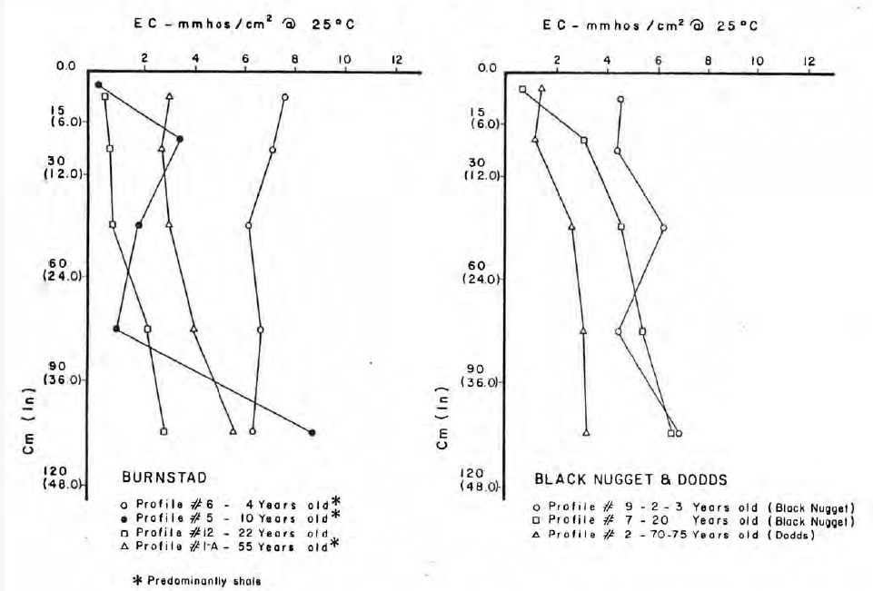
Resource
Authors
Sandra Landsburg
Karen Cannon
Nancy Finlayson
No clear relationships emerged between soil Orders, zones, or soil parent materials and the effect of pipeline construction on soil compaction. Soil moisture conditions appear to be more important.
Resource
Authors
Karen Cannon
Nancy Finlayson
Sandra Landsburg
At each of the fifteen 1989 study areas and at each of the eight 1988 study areas soil strength was monitored using a cone penetrometer in 15 cm depth increments to a depth of 52.5 cm.
Resource
A recent study (using a 10% stratified random sample) estimated the amount of area physically disturbed by energy related activity, to be 66,576 acres (26,963 ha) for a selective study area...
Resource
Authors
J.P. Verschuren
L. Wojtiw
Point measurements of maximum depth showed that over 50% of the rainstorms occur in June and July, with only a small percentage in April (5.6) and September (10. 1).
Resource
Authors
Maurice Dusseault
Hal Soderberg
The post-reclamation subsidence of cast-back overburden is of interest to mining companies and regulatory agencies. Although subsidence may be of lesser concern than the prevention of soil degradation...
Resource
Authors
Alberta Environment and Parks
Canada is a party to the UN Convention on Biological Diversity, which identifies the conservation and restoration of biological diversity as a global priority. It is incumbent on the provinces and...