Land Management Search Results
Resource
Understanding how birds respond to landscape disturbance is key to effective restoration. Two studies used non-invasive microphone arrays to determine the exact locations of singing individuals in the...
Resource
Authors
Alberta Biodiversity Monitoring Institute
From1999 to 2015, human activity in Alberta visibly converted over 23,000 km2 of native ecosystems into residential, recreational, or industrial landscapes
Resource
Resource Date:
August
2021
With the support of Alberta Environment and Parks, the Alberta Biodiversity Monitoring Institute has become the trusted source for data about habitat, species, and the human footprint.
Resource
Authors
Alberta Biodiversity Monitoring Institute
In summer 2013 field crews spent five weeks sampling soil and vegetation indicators at 18 wellsites and adjacent reference sites in the Dry Mixedgrass subregion of Alberta
Resource
Authors
Jocelyn Gregoire
Richard Hedley
Erin Bayne
Seismic lines have an extensive footprint in Canada's western boreal forest that alter habitat conditions for many species. Seismic lines exist within a range of seral states due to changing practices...
Resource
As caribou habitat restoration initiatives have become more widespread across Alberta in the last decade, key uncertainties have been recognized regarding what treatment types are appropriate for...
Resource
Authors
Jean Birks
Yi Yi
Sunny Cho
Emily Taylor
John Gibson
This study was conducted to characterize the composition of polar dissolved organic compounds present in snow and surface waters in the Athabasca Oil Sands Region (AOSR) with the goal of identifying...
Resource
Authors
Jean Birks
Yi Yi
Sunny Cho
John Gibson
Rod Hazewinkel
Goal was identifying whether atmospherically-derived organics present in snow are a significant contributor to the organics detected in rivers and lakes in the oil sands region
Resource
Authors
D.W. Mayhood
Linda Corkum
Baseline data available on the Muskeg River hydrology, benthic invertebrates, plankton and fish are generally useful, but additional information is desireable
Resource
The present volume evaluates the 1980 monitoring program, and makes suggestions for the conduct of future monitoring studies on the Muskeg River and elsewhere in the AOSERP area
Resource
Authors
Roger Whitehead
F. Cortini
S.W. Taylor
A.F. Linnell Nemec
J.W. Goudie
J. Vallentgoed
K.R. Polsson
The Stony Lake trial was established in 1987 to benchmark growth performance of interior spruce ( Picea glauca [Moench] Voss x engelmannii Parry ex Engelm.) and lodgepole pine ( Pinus contorta Dougl...
Resource
Authors
Nature Conservancy of Canada
Conservation Assessment for Southern Canada The Nature Conservancy of Canada (NCC) has completed a comprehensive assessment of the conservation needs and opportunities in southern Canada. The first of...
Resource
Authors
James Saracco
Peter Pyle
Danielle Kaschube
Monica Kohler
Christine Godwin
Kenneth Foster
Habitat loss and disturbance from industrial resource development may be contributing to declines in boreal bird populations. We applied hierarchical multi-species models to data from 31 bird species...
Resource
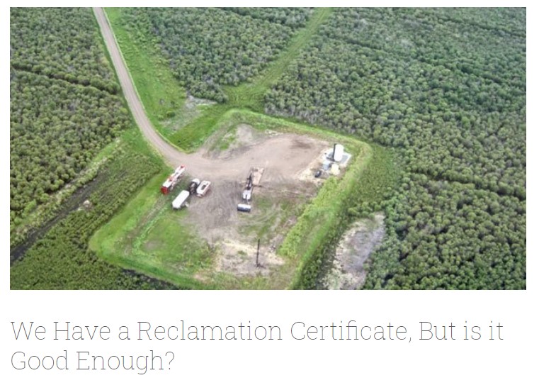
Long-term monitoring of some sites would ultimately be needed to show that recovering wellsites are on a trajectory that consistently leads to full recovery.
Resource
Pilot study to assess the use of early successional stands (i.e. those ranging in age from 4 to 17 years) by wildlife (songbirds, small mammals, and ungulates), using a wildlife monitoring protocol
Resource
Authors
Roger DeAbreu
Shane Patterson
Todd Shipman
Chris Powter
NRCan pilot science projects have proven that Earth Observation can provide relevant and valuable information to inform and enhance monitoring and support regulatory frameworks
Resource
There was only very limited evidence of biological responses to increased pollutant content in spite of significantly higher pollutant levels in tissues close to existing industrial developments.
Resource
Authors
ERMP Project Advisory Group
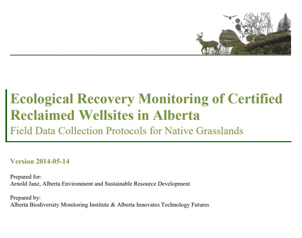
Monitoring protocols for forested land wellsites to determine if a reclaimed site has returned to similar structure and function as found in a representative undisturbed reference area.
Resource
Authors
Alberta Biodiversity Monitoring Institute
Select appropriate vegetation, soil, and habitat indicators for a long-term reclamation monitoring program and provide sampling protocols for the selected indicators.
Resource
Our statistical design and the hands on learning experience we gained in the field can be applied when implementing the long-term monitoring program for certified wellsites.