Land Management Search Results
Resource
Study Focus: Six years of hydrochemical data (2013 – 2018) from the Sandhill Fen Watershed (SFW), a 52-ha upland-peatland catchment that was built upon highly saline soft tailings, were used to...
Resource
Flood frequency prediction for Syncrude Lease 17 is necessary for both mining activities and environmental protection. Flood frequency curves can be derived from one year’s local data
Resource
Authors
Ginny Marshall
Dan Thompson
Kerry Anderson
Brian Simpson
Current methods of predicting fire spread in Canadian forests are suited to large wildfires that spread through natural forests. Recently, the use of mechanical and thinning treatments of forests in...
Resource
The impact of saline waters upon freshwater biota, having special reference to the AOSERP study area, is reviewed. Toxicity summaries for individual ions are presented.
Resource
Authors
Rachel Hovel
Jeremy Brammer
Emma Hodgson
Amy Amos
Trevor Lantz
Chanda Turner
Tracey Proverbs
Sarah Lord
Rapid environmental change in the Arctic elicits numerous concerns for ecosystems, natural resources, and ways of life. Robust monitoring is essential to adaptation and management in light of these...
Resource
Resource Date:
August
2020
This document is part of the 360 tours project Toolkit developed by Canada's Oil Sands Innovation Alliance (COSIA) led by Cenovus Energy Inc., in collaboration with Natural Resources Canada. The...
Resource
Authors
Erin Bayne
Cameron Nordell
Jesse Watson
Melynda Johnson
Adam Moltzahn
Janet Ng
The Ferruginous Hawk (FEHA) has been listed as an Endangered Species under the Alberta Wildlife Act by the provincial government since 2006 (Alberta FEHA Recovery Team 2009); and were re-listed as a...
Resource
Authors
Angeline Van Dongen
Caren Jones
Amanda Schoonmaker
Jill Harvey
Dani Degenhardt
Resource Date:
November
2022
Alberta’s forests are becoming increasingly disturbed and fragmented by the cumulative effects of anthropogenic distur�bances exacerbated by the enduring footprint of seismic lines on the landscape...
Resource
Registered trappers were 70 percent native; the average age was 46. The majority held other jobs concurrently, and spent less than two months on the trapline in 1975-76 (a low year on the fur cycle).
Resource
Authors
Alexis Jorgensen
Raquel Alfaro-Sanchez
Steven Cumming
Alison White
Genevieve Degre-Timmons
Nicola Day
Merritt Turetsky
Jill Johnstone
Xanthe Walker
Jennifer Baltzer
Climate change is increasing the frequency and extent of fires in the boreal biome of North America. These changes can alter the recovery of both canopy and understory vegetation. There is uncertainty...
Resource
A four year study has been carried out to determine the ability of coniferous trees to aid in the reclamation of uranium tailings at Elliot Lake. Five species were planted: white cedar, white spruce...
Resource
Study concentrated on the well-documented 1981 right-of-way, and compared it to the oldest trench, installed in 1957, and to the undisturbed adjacent mixed prairie
Resource
Authors
Peter Nix
D.W.S. Westlake
R.T. Coutts
F.M. Pasutto
Incubation of samples taken along a transect of the river just downstream from the oil sands plants showed higher rates of microbial degradation on the west bank where effluents and drainage would be
Resource
Authors
P.D. Anderson
P. Spear
S. D'Apollinia
S. Perry
J. Deluca
J. Dick
Goal of the project was the establishment of criteria safeguarding fish from toxic effects of mixtures of vanadium, nickel, and phenol to fish; all are associated with oil sands developments
Resource
Authors
Guillermo Castilla
Ronald Hall
Rob Skakun
Michelle Filiatrault
André Beaudoin
Michael Gartrell
Lisa Smith
Kathleen Groenewegen
Chris Hopkinson
Jurjen van der Sluijs
Resource Date:
February
2022
Wall-to-wall 30 m raster maps of broad forest type, stand height, crown closure, stand volume, total volume, aboveground biomass, and stand age were created for a ~400,000 km2 area, validated with independent data, and generalized into a polygon GIS layer resembling a traditional FI map. The MVI project showed that a reasonably accurate FI map for large, remote, predominantly non-inventoried boreal regions can be obtained at a low cost by combining limited field data with remote sensing data from multiple sources.
Resource
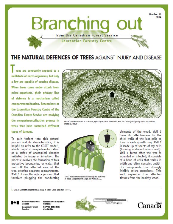
Trees are constantly exposed to a multitude of micro-organisms, but only a few are capable of causing disease. When trees come under attack from micro-organisms, their primary line of defence is a...