Wetlands Knowledge Search Results
Resource
Authors
Humaira Enayetullah
Laura Chasmer
Chris Hopkinson
Daniel Thompson
Danielle Cobbaert
Seismic lines are the dominant anthropogenic disturbance in the boreal forest of the Canadian province of Alberta, fragmenting over 1900 km 2 of peatland areas and accounting for more than 80% of all...
Resource
Authors
Chris Stockdale
Quinn Barber
Amit Saxena
Marc-Andre Parisien
Resource Date:
March
2019
We undertook a wildfire risk assessment across the Cold Lake caribou range where we used the Burn-P3 model to determine: a) burn probability; b) wildfire risk to restored seismic line areas; and c) the effectiveness of mitigation measures. The burn probability of the landscape was highly heterogeneous, and recent large burns and some waterbodies provided “shields” that reduced burn probability on their leeward sides.
Resource
Literature review provides an understanding of ecological resilience as a concept to promote successful land reclamation in Alberta’s mineable oil sands region
Resource
Authors
Kevin Renkema
Dean MacKenzie
Natalie Shelby‐James
Bin Xu
Chris Powter
The pilot study validated the research questions, sampling design, measurement and data analysis methods developed for a large‐scale study, with some minor amendments.
Resource
Authors
Melanie Dickie
Robert Serrouya
Scott McNay
Stan Boutin
Predation by grey wolves Canis lupus has been identified as an important cause of boreal woodland caribou Rangifer tarandus caribou mortality, and it has been hypothesized that wolf use of human...
Resource
Resource Date:
August
2020
This document is part of the 360 tours project Toolkit developed by Canada's Oil Sands Innovation Alliance (COSIA) led by Cenovus Energy Inc., in collaboration with Natural Resources Canada. The...
Resource
A cooperative trial to test the use of vegetation to enhance treatment of soils contaminated with weathered petroleum hydrocarbons (PHCs) was initiated in 2002. Experimental protocols were adapted...
Resource
In 2017-2018, Canada's Oil Sands Innovation Alliance (COSIA) partnered with the Canadian Forest Service - Natural Resources Canada (NRCan) to develop a suite of extension products. These products...
Resource
An undated “frequently asked questions” document from the Yukon Government on the opening up of the Arctic National Wildlife Refuge (calving ground of the Porcupine caribou herd) to industrial...
Resource
Resource Date:
October
2009
This resource is available on an external database and may require a paid subscription to access it. It is included on the CCLM to support our goal of capturing and sharing the breadth of all...
Resource
Authors
United Nations Environment Programme
Resource Date:
November
2022
Peatlands are unique and rare ecosystems that, despite only covering around 3-4% of the planet’s land surface, they contain up to one-third of the world’s soil carbon, which is twice the amount of...
Resource
This glossary was prepared to provide those working in the field of reclamation in Alberta with a standardized set of definitions for reclamation terms.
Resource
Authors
Oil Sands Research and Information Network
Glossary provides understanding of the language and acronyms used in oil sands mining, processing and environmental management.
Resource
Authors
Tracy McKay
Gordon Stenhouse
In 2010 and 2011, the Foothills Research Institute Grizzly Bear Program (FRIGBP) received funding from the Alberta Upstream Petroleum Research Fund (AUPRF) and other program partners to investigate...
Resource
Authors
Tracy McKay
Karen Graham
Gordon Stenhouse
This report includes results from two years of research investigating grizzly bear response to oil and gas pipelines in the Kakwa region of west-central Alberta. We investigated grizzly bear habitat...
Resource
Authors
Jean Birks
John Manchuk
Yi Yi
Cynthia McClain
Michael Moncur
John Gibson
Clayton Deutsch
Emily Taylor
Guy Bayegnak
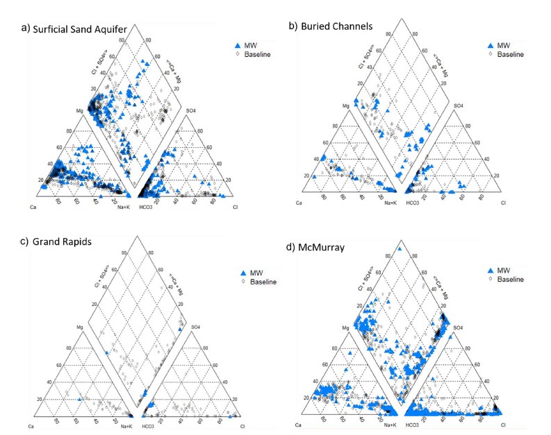
Groundwater quality data for the AOSR are compiled and interpreted to provide information on regional water quality to inform groundwater monitoring and land use planning. A database of 546 water...
Resource
Authors
Jean Birks
John Manchuk
Yi Yi
Cynthia McClain
Michael Moncur
John Gibson
Clayton Deutsch
Emily Taylor
Guy Bayegnak
Groundwater quality data for the AOSR are compiled and interpreted to provide information on regional water quality to inform groundwater monitoring and land use planning. A database of 546 water...
Resource
Authors
Heather Tokay
Dean MacKenzie
Chris Powter
Bonnie Drozdowski
Kevin Renkema
This document provides five case studies to show how the Guide to Variance Justifications for Reclamation Certification would be applied to real‐world examples of reclamation certificate applications
Resource
Authors
Heather Tokay
Dean MacKenzie
Chris Powter
Bonnie Drozdowski
Kevin Renkema
This document was developed to provide guidance and consistency in applying for and approving variance requests for reclamation certification of upland sites from an ecological perspective.
Resource
Authors
Kevin Renkema
Heather Tokay
Dean MacKenzie
Natalie Shelby-James
Chris Powter
Practitioners tested the Guide to Variance Justifications on four of those sites; three had been previously approved and one had been submitted and was pending a decision.