Wetlands Knowledge Search Results
Resource
Authors
Kevin Smith
Christopher Smith
Silvie Forest
Alain Richard
This guide provides an in-depth look at Ducks Unlimited Canada's (DUC) remote-sensing satellite mapping efforts and the development of the DUC enhanced wetland classification system.
Resource
The boreal mixedwood forest ecosystem includes both coniferous and deciduous tree species and is a common and widespread ecosystem in the Canadian boreal forest resulting from harvesting, forest fires...
Resource
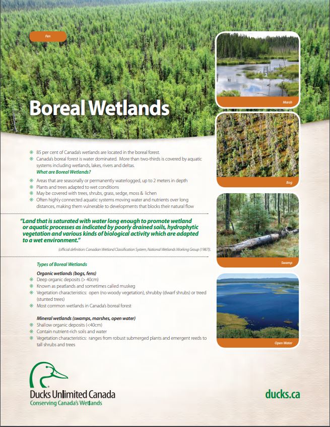
These fact sheets highlight plant, soil, and water indicators and key ecological benefits of each of the five major wetlands types.
Resource
Salix interior Rowlee (INT) is a wide-ranging North American willow from the small taxonomic group Salix section Longifoliae, notable for its ability to form multi-stemmed vegetative stem colonies...
Resource
Authors
Erin Mallon
Merritt Turetsky
Ian Thompson
John Fryxell
Philip Wiebe
Boreal forest development is influenced by both natural and anthropogenic disturbances that alter stand structure and nutrient cycling over decadal timescales. The effects of disturbance on boreal...
Resource
Ducks Unlimited Canada has been leading the effort to provide detailed and accurate wetland maps for large areas of the western boreal forest. These mapping products have become the cornerstone of DUC...
Resource
Studies to determine levels and impacts of soil disturbance caused during root-disease control by stump removal were initiated on a cutover on southern Vancouver Island immediately prior to the...
Resource
Authors
Anne McIntosh
Bonnie Drozdowski
Dani Degenhardt
Chris Powter
Christina Small
John Begg
Dan Farr
Arnold Janz
Randi Lupardus
Delinda Ryerson
Jim Schiek
We developed a scientifically robust and financially sustainable monitoring protocol to enable a consistent assessment of ecological recovery at reclaimed industrial wellsites in forested lands
Resource
Authors
Jay Woosaree
Brij Verma
Byron James
Phytoremediation, the use of plants to remove, degrade or stabilize sites contaminated with organic or toxic chemicals is gaining in popularity as an alternative and economical technique in...
Resource
Authors
Richard Johnson
P. Bork
E.A.D. Allen
W.H. James
L. Koverny
The experiments detailed in this report show that it was possible to increase the solids content of sludge to 50% solids by adding three parts sand (tailings sand) to one part sludge.
Resource
Authors
Camille Defrenne
Jessica Moore
Colin Tucker
Louis Lamit
Evan Kane
Randall Kolka
Rodney Chimner
Jason Keller
Erik Lilleskov
Drainage-induced encroachment by trees may have major effects on the carbon balance of northern peatlands, and responses of microbial communities are likely to play a central mechanistic role. We...
Resource
Authors
Lorna Harris
David Olefeldt
Nicolas Pelletier
Christian Blodau
Klaus-Holger Knorr
Julie Talbot
Liam Heffernan
Merritt Turetsky
Resource Date:
August
2023
Rapid, ongoing permafrost thaw of peatlands in the discontinuous permafrost zone is exposing a globally significant store of soil carbon (C) to microbial processes. Mineralization and release of this...
Resource
Diesel invert wastes are one of the more difficult types of drilling mud wastes to dispose of due to the presence of hydrocarbons and salts. In 1989 a joint research program funded by the Alberta...
Resource
Authors
Laura Chasmer
Edberto Moura Lima
Craig Mahoney
Chris Hopkinson
Joshua Montgomery
Danielle Cobbaert
Resource Date:
August
2021
Bi-temporal LiDAR data used to identify correspondence between density of anthropogenic disturbances, wetland shape complexity and changes in vegetation height within >1800 wetlands near Fort McKay
Resource
Authors
Guillermo Castilla
Ronald Hall
Rob Skakun
Michelle Filiatrault
André Beaudoin
Michael Gartrell
Lisa Smith
Kathleen Groenewegen
Chris Hopkinson
Jurjen van der Sluijs
Resource Date:
February
2022
Wall-to-wall 30 m raster maps of broad forest type, stand height, crown closure, stand volume, total volume, aboveground biomass, and stand age were created for a ~400,000 km2 area, validated with independent data, and generalized into a polygon GIS layer resembling a traditional FI map. The MVI project showed that a reasonably accurate FI map for large, remote, predominantly non-inventoried boreal regions can be obtained at a low cost by combining limited field data with remote sensing data from multiple sources.
Resource
Authors
Dale Vitt
Melissa House
Lilyan Glaeser
Minerogenous peatlands that accumulate deep deposits of organic matter (fens) were an important part of the pre-disturbance landscape across Alberta’s oil sands mining area. Bryophytes occupy 80–100%...
Resource
Authors
Terry Macyk
Zdenek Widtman
Vernon Betts
The Alberta Research Council has conducted a surface mine reclamation research program in association with the operations of Smoky River Coal Ltd. near Grande Cache, Alberta since 1972. The main...
Resource
On 19th June 2023, BirdWatch Ireland hosted an online presentation by Dr. Flo Renou Wilson, peatland expert from University College Dublin. Participants included members of different organisations...
Resource
Our Nature talk on Tuesday, July 4th, featured Rachel Kendall and her work surrounding the forested wetlands of Nova Scotia. Rachel loves exploring and gaining new understandings of how plants, soil...
Resource
Resource Date:
March
2020
This presentation provides an overview of methods for delineating wetland boundaries using a three-factor approach, which involves indicators of hydrophytic vegetation, hydric soil, and wetland...