Wetlands Knowledge Search Results
Resource
Ground water conditions are frequently overlooked when placing surface materials in a mine reclamation scheme. The purpose of this paper is to outline the interaction between the surface materials and...
Resource
Authors
Alex Horne
Marc Beutel
Greg Woodside
Nitrate pollution of surface water from farms and urban runoff is widespread – impairing drinking water supplies, recreation, and wildlife habitat. The scale of the problem in rivers has overwhelmed...
Resource
Resource Date:
August
2020
This document is part of the 360 tours project Toolkit developed by Canada's Oil Sands Innovation Alliance (COSIA) led by Cenovus Energy Inc., in collaboration with Natural Resources Canada. The...
Resource
Authors
Stephanie Bascu
Christopher Spence
Wetlands that occupy topographic depressions are a defining feature of the Canadian Prairie. These features control hydrological connectivity as they contain high storage capacity relative to...
Resource
Authors
Jim Davies
Ryan Melnichuk
Craig Aumann
Zhongzhi Chen
Brian Eaton
An aquatic mesocosm facility consisting of thirty 15,000 L tanks was constructed in Vegreville, Alberta to support environmental research. In 2017, an experiment was conducted as an inaugural run for...
Resource
Authors
Spencer Chad
Lee Barbour
Jeffrey McDonnell
John Gibson
Water samples were collected and analyzed regularly over an eight-year period to establish inventories of site-wide water isotope signatures including seasonal and interannual changes in the recycle...
Resource
Authors
Emma Bocking
David Cooper
Johnathan Price
Resource Date:
November
2017
This resource is available on an external database and may require a paid subscription to access it. It is included on the CCLM to support our goal of capturing and sharing the breadth of all...
Resource
Authors
Laureen Echiverri
Ellen Macdonald
Resource Date:
September
2019
For the purpose of informing biodiversity conservation efforts in managed landscapes, we explored whether and how understory plant communities (abundance, diversity, composition) were related to a...
Resource
Authors
Tegan Holmes
Tricia Stadnyk
Masoud Asadzadeh
John Gibson
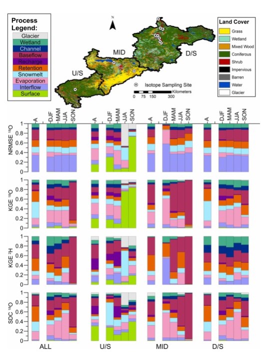
This study evaluates whether combined use of streamflow and isotope tracer performance metrics can improve representation of simulated streamflow-generating processes within a large river basin, the...
Resource
Resource Date:
November
2020
The Vermillion River watershed region, found in central Alberta between Edmonton and Lloydminster, is home to residents and farmers who rely on the watershed for drinking water, agriculture, and...
Resource
This presentation discusses the Alberta water extent monitoring pilot study, with the goal to create a database that has the potential for implementation at a provincial level.
Resource
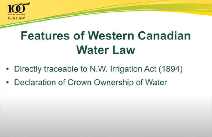
This talk summarizes the progression of water law and water rights policy in Western Canada and provides some possible solutions for current and emerging challenges.
Resource
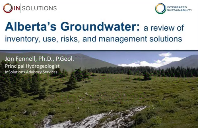
This 2016 talk provides an overview of some of the issues related to groundwater in Alberta.
Resource
This public symposium covers Alberta's progress to improve its flood and drought resiliency, including the role of natural solutions. NOTE: This is a 4 hour video with multiple presenters
Resource
This presentation was a part of the Petroleum Technology Alliance of Canada, Hydraulic Fracturing in Western Canada: an Environmental Perspective Forum, in May of 2014.
Resource
The various applications of Ducks Unlimited Canada’s wetland inventories play a critical role in wetland conservation. They serve as key planning tools, helping people who live and work in the boreal...
Resource
The presentation describes the purpose and development of a water purification model that can be used to help decision-makers evaluate tradeoffs for land use development proposals
Resource
This presentation talks about Bathymetric LiDARs for Hydrographic Mapping with a focus on ALTM systems and data fusion.
Resource
In order to protect boreal wetlands, we must first know where they are. This 6-minute video will show you how Ducks Unlimited Canada uses satellite data and remote sensing techniques to map wetlands...
Resource
Dr. Barry White reviews the progress made with LiDAR and wet area mapping in Alberta.