
Search Results
Displaying:
1 - 9 of 9
4-day SST Version 3.0 Certification Course
Event
Event Date and Time
April 9th, 2024 at 9:00am MST to April 12th, 2024 at 4:30pm MST
This 4 day course includes over three days of instruction on theory, software tool operation, and case studies, with the exam on the fourth day (four-hour comprehensive exam). Students achieving a...
Course: Subsoil Salinity Tool (SST) Version 3.0 - 2 Day Update
Event
Event Date and Time
April 19th, 2022 at 8:00am EST to April 20th, 2022 at 4:30pm EST
Calgary, AB
This 2 day update course provides a description of changes to chloride guideline calculations from the previous version (v2.5.3), and also describes the SAR and sodium guideline calculations introduced into Version 3.0

Course: Subsoil Salinity Tool (SST) Version 3.0 - 4-day Certification
Event
Event Date and Time
April 26th, 2022 at 8:00am MST to April 29th, 2022 at 4:30pm MST
Organization
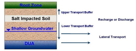
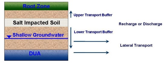
The Alberta Environment and Parks (AEP) Subsoil Salinity Tool (SST) Version 3.0 is a software tool used to generate Tier 2A and 2B Subsoil Remediation Guidelines (SRGs) for chloride, SAR and sodium...
Plant Functional Traits as Indicator of the Ecological Condition of Wetlands in the Grassland and Parkland of Alberta, Canada
Resource
The analysis of functional trait-habitat relationships has been used to measure the degree to which environmental factors influence the assembly of ecological communities. In the Parkland and...

SST Version 3.0 Certification Course
Event
Event Date and Time
September 12th, 2023 at 8:00am MST to September 15th, 2023 at 4:30pm MST
Organization
Equilibrium Environmental will present a full 4-day online SST Version 3.0 certification course in September. It is not mandatory for practitioners who are already certified in a previous version of...
Subsoil Salinity Tool (SST) Version 3.0 Course
Event
Event Date and Time
April 18th, 2023 at 8:00am MST to April 21st, 2023 at 4:30pm MST
Organization
The Alberta Environment and Parks (AEP) Subsoil Salinity Tool (SST) Version 3.0 is a software tool used to generate Tier 2A and 2B Subsoil Remediation Guidelines (SRGs) for chloride, SAR and sodium...
The Third Generation of Pan-Canadian Wetland Map at 10 m Resolution Using Multisource Earth Observation Data on Cloud Computing Platform
Resource
Development of the Canadian Wetland Inventory Map (CWIM) has thus far proceeded over two generations, reporting the extent and location of bog, fen, swamp, marsh, and water wetlands across the country...
Using GIS and Remote Sensing to Monitor Industrial Impacts to Archaeological Sites in the Athabasca Oil Sands of Alberta
Resource
The Athabasca Oil Sands (AOS) region of Alberta has one of the densest accumulations of known archaeological sites, and possibly the most archaeological sites at risk, in the country. Expanding...
