Search Results
Displaying:
1 - 20 of 330
10th Annual World Wetlands Day Research Symposium at the University of Waterloo
Event
Event Date and Time
February 2nd, 2022 at 12:00am to February 2nd, 2022 at 11:59pm
Organization
Each year since 2013, the University of Waterloo's Ecohydrology research group has hosted a World Wetlands Day event. You can read about past events on their website at https://uwaterloo.ca...

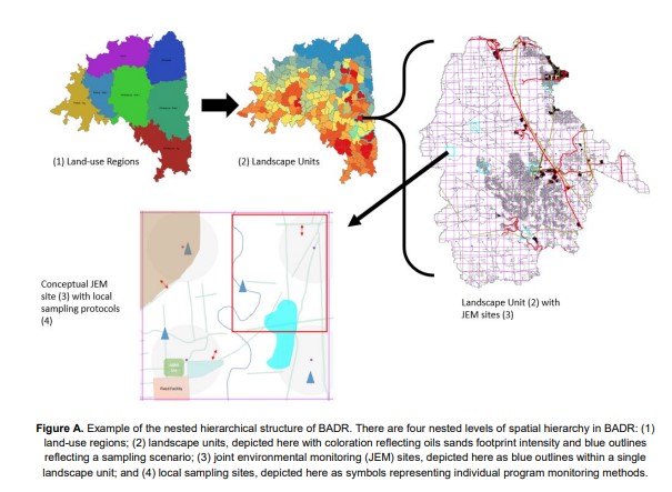
A Before-After Dose-Response (BADR) Terrestrial Biological Monitoring Framework for the Oil Sands
Resource
One of the theme areas monitored within the OSM program is terrestrial biodiversity, known programmatically as Terrestrial Biological Monitoring (TBM). Biodiversity refers to the diversity of wild...
A Burning Question: What are the Implications of Forest Fires for Woodland Caribou?
Resource
This resource is available on an external database and may require a paid subscription to access it. It is included on the CCLM to support our goal of capturing and sharing the breadth of all...

A Deeper Dive into Human Footprint in Alberta
Resource
As of 2015, 29.2% of Alberta is under human footprint, up from 25.7% in 1999—that’s an average increase of about 0.22%, or around 1450 km2 (560 sections) per year.

A Framework for Adaptive Monitoring of the Cumulative Effects of Human Footprint on Biodiversity
Resource
Effective ecological monitoring is imperative in a human-dominated world, as our ability to manage functioning ecosystems will depend on understanding biodiversity responses to anthropogenic impacts...
A Greener World May Hold Red Flags for Woodland Caribou
Resource
A team from the ABMI’s Caribou Monitoring Unit, studied links between habitat alteration (e.g., forest harvesting), primary productivity, moose, wolves, and caribou across the Canadian boreal forest
A Hydrogeological Landscape Framework to Identify Peatland Wildfire Smouldering Hot Sports
Resource
Northern peatlands are important global carbon stores, but there is concern that these boreal peat reserves are at risk due to increased fire frequency and severity as predicted by climate change...

A Hydrogeological Landscape Framework to Identify Peatland Wildfire Smouldering Hot Spots
Resource
This study used a combination of field measurements and modelling to assess the vulnerability of peat to smouldering in the Utikuma Region Study Area, Alberta, Canada.

A Literature Review for Monitoring Rare and Elusive Species, and Recommendations on Survey Design for Monitoring Boreal Caribou
Resource
Effective wildlife management requires monitoring changes in the spatial distribution of species, their population size and their population trend (Williams et al. 2002; Sinclair et al. 2006)...

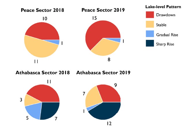
A New Lake Classification Scheme for the Peace-Athabasca Delta (Canada) Characterizes Hydrological Processes that Cause Lake-level Variation
Resource
Recent drawdown of the delta’s abundant shallow lakes and rivers has deteriorated vital habitat for wildlife and impaired navigation routes. Here, we report continuous measurements at ~50 lakes during...
A New Method to Map Groundwater Table in Peatlands Using Unmanned Aerial Vehicles
Resource
Groundwater level (GWL) and depth to water (DTW) are related metrics aimed at characterizing groundwater-table positions in peatlands, and two of the most common variables collected by researchers...
A Regional-Scale Index for Assessing the Exposure of Drinking-Water Sources to Wildfires
Resource
Recent human-interface wildfires around the world have raised concerns regarding the reliability of freshwater supply flowing from severely burned watersheds. Degraded source water quality can often...
A Synthesis of Three Decades of Eco-Hydrological Research at Scotty Creek, NWT, Canada
Resource
Scotty Creek, Northwest Territories (NWT), Canada, has been the focus of eco-hydrological research for nearly three decades. Over this period, field and modelling studies have generated new insights...
A Temporal Snapshot of Ecosystem Functionality During the Initial Stages of Reclamation of an Upland-fen Complex
Resource
AOSR pre-disturbance landscape consists of a mosaic of upland-peatland complexes, dominated by fens, which have become the focus of recent mandatory reclamation efforts. Quantifiable metrics for...
ABMI LiDAR Data to be Made Available to the Public
News
Organization
In partnership with various funders and collaborators, the ABMI has been collecting LiDAR data since 2022. During 2024, some of these data—covering approximately 5,600 square kilometres of Alberta...
ABMI Releases the Wetland Atlas of Alberta
News
Organization
The Alberta Biodiversity Monitoring Network (ABMI) has released an online report titled the Wetland Atlas of Alberta; which, for the first time, pulls together publicly accessible information on...
ABMI Science Letter: Factors Affecting Nutrient Variation in Alberta Prairie Wetlands
Resource
Our results indicate water depth, surrounding agriculture footprint, and amount of precipitation received all significantly influence the water quality of prairie wetlands in Alberta.

ABMI Webinar: WildTrax
Event
Event Date and Time
April 27th, 2022 at 12:00pm MST to April 27th, 2022 at 1:00pm MST
Organization
Want to use WildTrax but don't know where to start? Or are you already a WildTrax user, and want to learn more about its different features? Join us on April 27 for an overview of the WildTrax platform, soon fully available for use in English or French!

ABMI's Alberta Biodiversity Browser Updates
News
Organization
The Biodiversity Browser is the place to go to find all of the data and information we have compiled for the wide variety of species that the ABMI monitors. More than 3000 individual species profiles...