
Search Results
Displaying:
61 - 80 of 267
Creating a Detailed Wetland Inventory with Sentinel-2 Time-Series Data and Google Earth Engine in the Prairie Pothole Region of Canada
Resource
Wetlands in the Prairie Pothole Region (PPR) of Canada and the United States represent a unique mapping challenge. They are dynamic both seasonally and year-to-year, are very small, and frequently...

Critical Remote Sensing Targets for Boreal Wetlands Research and Management
Resource
This presentation discusses remote sensing to assess groundwater, microtopogpraphy and above-ground biomass, as well as wetland management. Presented at the NAIT 7th Seminar on Linear Disturbance...

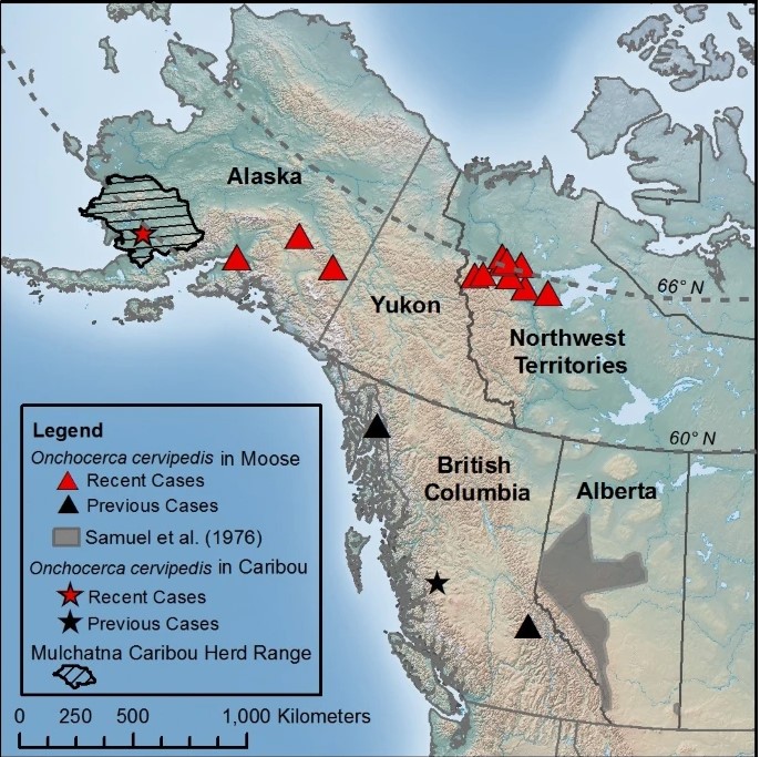
Defining Parasite Biodiversity at High Latitudes of North America: New Host and Geographic Records for Onchocerca Cervipedis (Nematoda: Onchocercidae) in Moose and Caribou
Resource
Onchocerca cervipedis is a filarioid nematode of cervids reported from Central America to boreal regions of North America. It is found primarily in subcutaneous tissues of the legs, and is more...
Demographic Declines Over Time and Variable Responses of Breeding Bird Populations to Human Footprint in the Athabasca Oil Sands Region, Alberta, Canada
Resource
Habitat loss and disturbance from industrial resource development may be contributing to declines in boreal bird populations. We applied hierarchical multi-species models to data from 31 bird species...

Demographic Responses of a Threatened, Low-density Ungulate to Annual Variation in Meteorological and Phenological Conditions
Resource
Study highlights the increased relevance of recovery actions when adverse climatic conditions are likely to negatively affect caribou demography.

Detection of Coniferous Seedlings in UAV Imagery
Resource
Rapid assessment of forest regeneration using unmanned aerial vehicles (UAVs) is likely to decrease the cost of establishment surveys in a variety of resource industries. This research tests the...
Developing Allometric Equations for Estimating Shrub Biomass in a Boreal Fen
Resource
This study develops allometric equations for three dominant genera found in boreal fens: Alnus spp. (alder), Salix spp. (willow) and Betula pumila (bog birch).
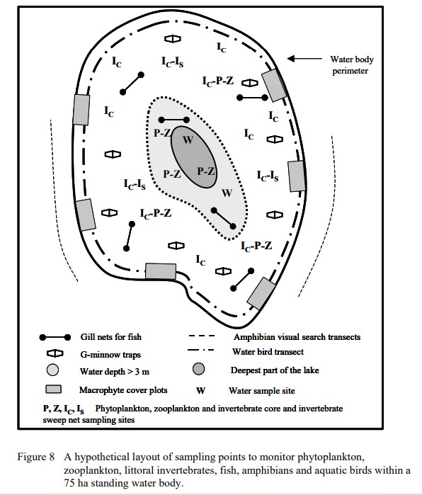
Developing Monitoring Protocols for Aquatic Ecosystems in Forested Regions of Alberta
Resource
This report is part of a larger endeavor to develop a monitoring program capable of detecting changes in the biological diversity of Alberta’s forested region.
Development of a Recovery Index to Quantify Ecological Recovery of Reclaimed Wellsites
Resource
Long-term monitoring of some sites would ultimately be needed to show that recovering wellsites are on a trajectory that consistently leads to full recovery.

Distribution and Abundance of Macrobenthos in the Athabasca River Near Fort McMurray
Resource
348 benthic macroinvertebrate samples collected at 16 sites along 85 km of the Athabasca River between Fort McMurray and the Ells River. total of 27229 specimens belonging to 68 taxonomic groups

Domains of Scale in Cumulative Effects of Energy Sector Development on Boreal Birds
Resource
We estimated cumulative effects of energy sector development on distributions of sixteen migratory songbird species at multiple spatial scales within the boreal region of Alberta, Canada, and...

Ecological Recovery Monitoring of Certified Reclaimed Wellsites in Alberta: Field Data Collection Protocols for Forested Lands
Resource
Monitoring protocols for forested land wellsites to determine if a reclaimed site has returned to similar structure and function as found in a representative undisturbed reference area.

Ecological Recovery Monitoring of Certified Reclaimed Wellsites in Alberta: Field Data Collection Protocols for Native Grasslands. Version 2014-05-14
Resource
Select appropriate vegetation, soil, and habitat indicators for a long-term reclamation monitoring program and provide sampling protocols for the selected indicators.
Ecological Recovery Monitoring of Certified Reclaimed Wellsites in Alberta: Long-term Monitoring Framework to Track Ecological Recovery - Results from the Dry Mixedgrass
Resource
Our statistical design and the hands on learning experience we gained in the field can be applied when implementing the long-term monitoring program for certified wellsites.

Ecological Recovery Monitoring of Certified Reclaimed Wellsites in Alberta: Selection of Indicators and Indicator Field Data Collection Protocols. Version 2014-04- 22
Resource
Three workshops were held to examine a suite of vegetation, soil, and habitat indicators that could potentially be used to monitor recovery in a long-term reclamation monitoring program

Ecological Recovery Monitoring of Dry Mixedgrass Wellsites: Results of Vegetation and Soil Indicator Analysis. Version 2017-03-02.
Resource
Data show that for many vegetation and soil indicators, wellsite development impacts are long lasting and may remain for 30 years or more after reclamation.

Ecological Recovery Monitoring Program (ERMP) for Certified Reclaimed Sites in Alberta: Monitoring Protocols for Cultivated Land Wellsites
Resource
This report provides the monitoring protocols for cultivated land wellsites.

Ecological Recovery Monitoring Program (ERMP) for Certified Reclaimed Sites in Alberta: Monitoring Protocols for Forested Land Wellsites
Resource
This report provides the monitoring protocols for forested land wellsites.

Ecological Recovery Monitoring Program (ERMP) for Certified Reclaimed Sites in Alberta: Monitoring Protocols for Grassland Wellsites
Resource
This report provides the monitoring protocols for grassland wellsites.
