
Search Results
Displaying:
141 - 160 of 305
Transportation Corridor Study. Volume 4 Appendix: Environment - General Characteristics & Conditions - Part 1
Resource
Contains the following sections: Environment Characteristics and Conditions; Soils; Wildlife; and, Preliminary Review and Land Evaluation

Transportation Corridor Study. Volume 4 Appendix: Environment - General Characteristics & Conditions - Part 2
Resource
Contains the following chapters: Environment Characteristics and Conditions; Soils; Wildlife; and Human Settlement Pattern of the Expanded Study Area

UAV Remote Sensing can Reveal the Effects of Low Impact Seismic Lines on Methane (CH4) Release in a Forested Boreal Bog
Resource
Peatlands are globally significant stores of soil carbon, where local methane (CH 4 ) emissions are strongly linked to water table position and microtopography. Historically, these factors have been...

Use of Unmanned Aerial Vehicles for Monitoring Recovery of Forest Vegetation on Petroleum Well Sites
Resource
Good statistical agreement between key structural vegetation parameters, such as mean and maximum vegetation height, with PPC metrics successfully predicting most height and tree-diameter metrics.

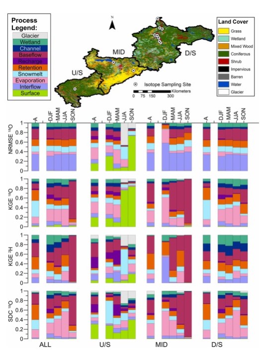
Variability in Flow and Tracer-based Performance Metric Sensitivities Reveal RFegional Differences in Dominant Hydrological Processes Across the Athabasca River Basin
Resource
This study evaluates whether combined use of streamflow and isotope tracer performance metrics can improve representation of simulated streamflow-generating processes within a large river basin, the...
Video - 2016 Wetland Best Management Practices Workshop: Opening Remarks
Resource
With over 75 years of experience and activity in every province and territory, Ducks Unlimited Canada (DUC) is a registered charity and a recognized leader in wetland conservation. DUC is a science...

Video - Applications of Wetland Inventories
Resource
The various applications of Ducks Unlimited Canada’s wetland inventories play a critical role in wetland conservation. They serve as key planning tools, helping people who live and work in the boreal...

Video - Boreal Wetlands Remote Sensing
Resource
In order to protect boreal wetlands, we must first know where they are. This 6-minute video will show you how Ducks Unlimited Canada uses satellite data and remote sensing techniques to map wetlands...

Video - Caribou and Development in West-Central AB/BC
Resource
Marco Musiani talks about research on caribou and development in west-central Alberta and British Columbia. An Associate Professor for the University of Calgary, Muisiani shows and explains the...

Video - Caribou and Development in West-Central Alberta and British-Columbia
Resource
Marco Musiani talks about research on caribou and development in west-central Alberta and British Columbia.

Video - Incorporation of Wetlands into Forest Management
Resource
The Duck Mountain Provincial Forest in west-central Manitoba is a landbase with a mosaic of uplands and wetlands. The wetlands are both interspersed and interconnected with uplands. Ecosystem Based...

Video - Innovative Information Management to Support Wetland Conservation
Resource
This presentation provides an overview of the Ducks Unlimited Canada Best Management Practices (BMP) program and the road to and purpose of the 2016 Wetland BMP Workshop.
Video - Multi-Temporal Remote Sensing: A New Perspective on the Dynamic Albertan Landscape
Resource
The presentation describes how multi-temporal remote sensing offers a better understanding of landscape changes over time in comparison to the more traditional two-date, before and after comparison.

Video - Soil Moisture Estimation Using Polarmetric Radarsat-2 Data
Resource
This presentation discusses soil moisture estimation using polarimetric Radarsat-2 data and remote sensing as a fast, cost-effective method for mapping wide areas.

Video - Wetland Retention and Restoration: A Business Case for Conservation in the Settled Areas of Alberta
Resource
This presentation explains the economic case for wetland conservation in the White Zone of Alberta.

Video - Wetlands 101
Resource
This 10-minute video will equip you with the knowledge to identify the different wetland classes found in Canada's boreal. Identification of wetland types is a first step toward conservation and a...

Webinar - The Canadian Model for Peatlands: A National Scale Peatland Carbon Accounting Model
Resource
The Canadian Model for Peatlands (CaMP) was developed to address growing international pressure on Canada to better account for greenhouse gas emissions from peatlands in national and international...
Webinar - A Road Runs Through it: What Happens when the Dam Road Gets in the Way
Resource
This webinar explores the effects of roads built through peatlands with horizontal water flow, including ability to affect local hydrology and thus vegetation composition and structure.
