Search Results
Displaying:
1 - 20 of 21
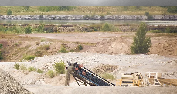
A Case Study of Materials and Techniques Used in the Rehabilitation of a Pit and a Quarry in Southern Ontario
Resource
Many after-uses of aggregate extraction land do exist: forestry, agriculture, recreation, nature reserves, housing and waste disposal sites. Attempts at reclaiming this land for alternate uses has...
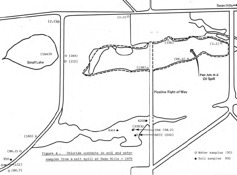
Brine Spillage in the Oil Industry: The Natural Recovery of an Area Affected by a Salt Water Spill near Swan Hills, Alberta
Resource
Salt spills are liable to become more prevalent in the oil producing regions of Alberta as the volume of brine relative to crude oil increases with the depletion of the older oil-fields. High...
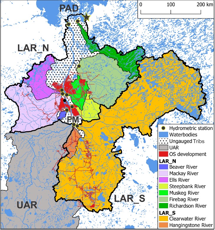
Changes in Geographical Runoff Generation in Regions Affected by Climate and Resource Development: A Case Study of the Athabasca River
Resource
The goal of this study is to enhance the understanding of the regional role of the lower Athabasca Basin areas in overall runoff delivery to the downstream Peace-Athabasca Delta. The Cold-regions...
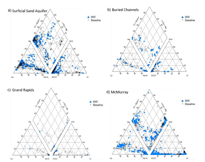
Groundwater Monitoring Near Oil Sands Development: Insights From Regional Water Quality Datasets in the Alberta Oil Sands Region (AOSR)
Resource
Groundwater quality data for the AOSR are compiled and interpreted to provide information on regional water quality to inform groundwater monitoring and land use planning. A database of 546 water...

Groundwater Monitoring Near Oil Sands Development: Insights from Regional Water Quality Datasets in the Alberta Oil Sands Region (AOSR)
Resource
Groundwater quality data for the AOSR are compiled and interpreted to provide information on regional water quality to inform groundwater monitoring and land use planning. A database of 546 water...
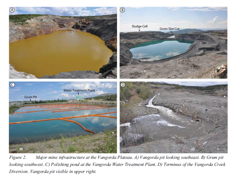
Implementation of Contaminated Water Management System Upgrades to Allow for Dewatering of Two Open Pits at the Vangorda Plateau, Faro Mine Complex, Yukon
Resource
The Vangorda Plateau at the Faro Mine Complex contains two open pits that, starting in 2013, will both require dewatering. Since mine abandonment in 1998, water levels in Vangorda pit have been...
Isotope-based Water Balance Assessment of Open Water Wetlands Across Alberta: Regional Trends with Emphasis on the Oil Sands Region
Resource
Water sampling for stable isotopes ( 18O and 2H) was carried out during 2009–2019 across Alberta, Canada, as part of a survey targeting 1022 open water wetlands. The study presents the first site...

Kelly Bannister
Contact
Organization
Position Title
Co-Director of POLIS Project on Ecological Governance
Oil Sands Research and Information Network: Creating and Sharing Knowledge to Support Environmental Management of the Mineable Oil Sands
Resource
The Oil Sands Research and Information Network (OSRIN) is a university-based, independent organization that compiles, interprets and analyses available knowledge about managing the environmental...
Paleolimnological Assessment of Past Hydro-ecological Variation at a Shallow Hardwater Lake in the Athabasca Oil Sands Region Before Potential Onset of Industrial Development
Resource
Effective environmental monitoring requires knowledge of inherent natural variation. In the absence of pre-development monitoring of aquatic ecosystems, paleolimnological approaches have been...

Passive Treatment of Mine Drainage Waters: The Use of Biochars and Wood Products to Enhance Metal Removal Efficiency
Resource
Passive biological treatments have been proposed as a possible efficient and cost effective treatment method for metal bearing water discharged from mine sites after closure. Several biofilters are...

Plant Functional Traits as Indicator of the Ecological Condition of Wetlands in the Grassland and Parkland of Alberta, Canada
Resource
The analysis of functional trait-habitat relationships has been used to measure the degree to which environmental factors influence the assembly of ecological communities. In the Parkland and...

Reclamation of Coal Refuse Material on an Abandoned Mine Site at Staunton, Illinois
Resource
In the Stat~ of Illinois lands that have been abandoned after deep mining or strip mining of coal present unique land reclamation problems. One such area is the Staunton l Reclamation Site. Through...

Reclamation Workshop: Towards a Shared Foundation for Innovation and Evolution
Resource
Seventy-eight reclamation practitioners from government, industry, consulting, academia, and the services sector gathered in Edmonton on March 6, 2024, to highlight and discuss specific issues facing...
Results of Vegetation Survey as a Part of Neutralizing Lime Sludge Valorization Assessment
Resource
The use of the lime neutralization process is a common technique to treat acid mine drainage (AMD) generated by sulphidic mine wastes. The AMD-contaminated water collected on the mine site is...

The Interaction of Groundwater and Surface Materials in Mine Reclamation
Resource
Ground water conditions are frequently overlooked when placing surface materials in a mine reclamation scheme. The purpose of this paper is to outline the interaction between the surface materials and...

The Third Generation of Pan-Canadian Wetland Map at 10 m Resolution Using Multisource Earth Observation Data on Cloud Computing Platform
Resource
Development of the Canadian Wetland Inventory Map (CWIM) has thus far proceeded over two generations, reporting the extent and location of bog, fen, swamp, marsh, and water wetlands across the country...
Using Stable Isotopes to Track Hydrological Processes at an Oil Sands Mine, Alberta, Canada
Resource
Water samples were collected and analyzed regularly over an eight-year period to establish inventories of site-wide water isotope signatures including seasonal and interannual changes in the recycle...

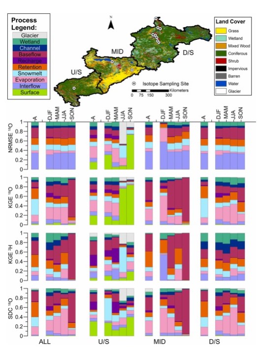
Variability in Flow and Tracer-based Performance Metric Sensitivities Reveal RFegional Differences in Dominant Hydrological Processes Across the Athabasca River Basin
Resource
This study evaluates whether combined use of streamflow and isotope tracer performance metrics can improve representation of simulated streamflow-generating processes within a large river basin, the...