
Search Results
Displaying:
1 - 9 of 9
Evaluating the Impact of Caribou Habitat Restoration on Predator and Prey Movement
Resource
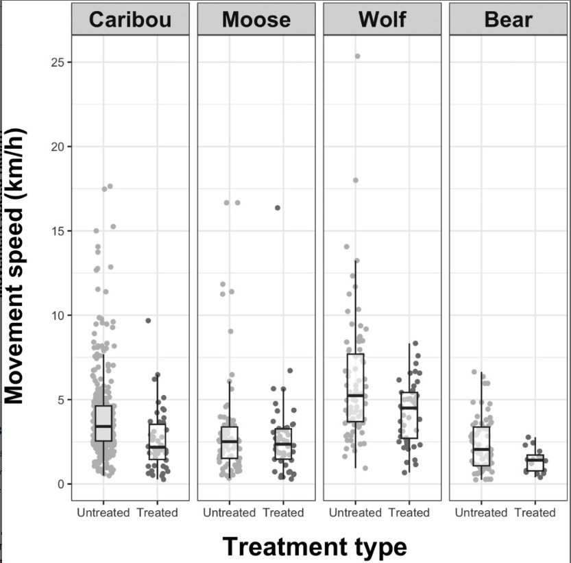
In the paper 'Evaluating the impact of caribou habitat restoration on predator and prey movement', the authors evaluated movement responses of wolves, black bears, caribou, and moose on seismic lines...

Evaluating the Impact of Caribou Habitat Restoration on Predator and Prey Movement
Resource
Fragmentation of the boreal forest by linear features, including seismic lines, has destabilized predator–prey dynamics, resulting in the decline of woodland caribou (Rangifer tarandus caribou)...
Improving the Fire Weather Index System for Peatlands using Peat-Specific Hydrological Input Data
Resource
The Canadian Fire Weather Index (FWI) system, even though originally developed and calibrated for an upland Jack pine forest, is used globally to estimate fire danger for any fire environment. However...

INFOGRAPHIC: Evaluating the Impact of Caribou Habitat Restoration on Predator and Prey Movement
Resource
In the paper 'Evaluating the impact of caribou habitat restoration on predator and prey movement', the authors evaluated movement responses of wolves, black bears, caribou, and moose on seismic lines...
Jonas Mortelmans
Contact
Organization
Position Title
PhD Researcher (Earth and Environmental Sciences)
Moose Response to Disturbance in West-central Alberta
Project
Contact
Organization:
This Caribou Program project examines how moose respond to different re-vegetation trajectories after disturbance. This will give re-vegetation prescriptions that favour moose less, and therefore are...
Restoration of Seismic Cutlines in Caribou Range in West-central and North-western Alberta: Maximizing Success and Targeting Areas Used by Alternative Prey
Project
Contact
Organization:
This single year Habitat Stewardship Program Species at Risk Stream project will improve threatened boreal caribou and endangered southern mountain caribou habitat by increasing undisturbed habitat...
Satellite Determination of Peatland Water Table Temporal Dynamics by Localizing Representative Pixels of A SWIR-Based Moisture Index
Resource
The OPtical TRApezoid Model (OPTRAM) is a physically-based approach for remote soil moisture estimation. OPTRAM is based on the response of short-wave infrared (SWIR) reflectance to vegetation water...
