
Search Results
Displaying:
1 - 8 of 8
A Regional-Scale Index for Assessing the Exposure of Drinking-Water Sources to Wildfires
Resource
Recent human-interface wildfires around the world have raised concerns regarding the reliability of freshwater supply flowing from severely burned watersheds. Degraded source water quality can often...

Evaluating the Impact of Caribou Habitat Restoration on Predator and Prey Movement
Resource
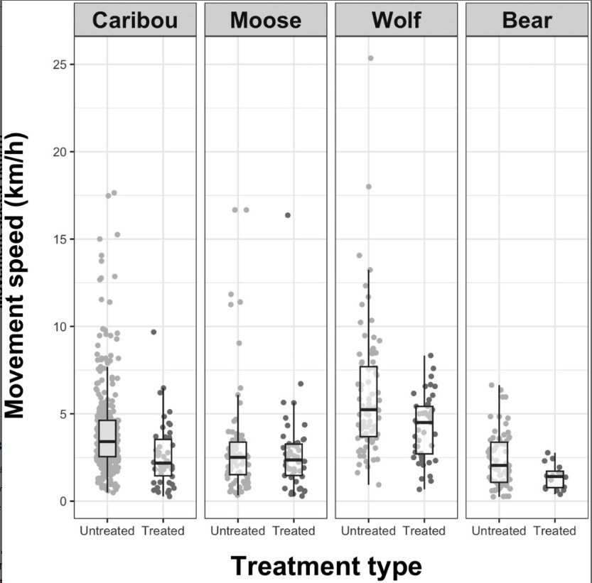
In the paper 'Evaluating the impact of caribou habitat restoration on predator and prey movement', the authors evaluated movement responses of wolves, black bears, caribou, and moose on seismic lines...

Evaluating the Impact of Caribou Habitat Restoration on Predator and Prey Movement
Resource
Fragmentation of the boreal forest by linear features, including seismic lines, has destabilized predator–prey dynamics, resulting in the decline of woodland caribou (Rangifer tarandus caribou)...
INFOGRAPHIC: Evaluating the Impact of Caribou Habitat Restoration on Predator and Prey Movement
Resource
In the paper 'Evaluating the impact of caribou habitat restoration on predator and prey movement', the authors evaluated movement responses of wolves, black bears, caribou, and moose on seismic lines...
Local Hydroclimatic Influence on Black Spruce (Picea mariana (Mill.) B.S.P.) Anatomical Traits in Two Boreal Fen Peatlands
Resource
As global temperatures increase, ongoing research is essential in understanding the long-term effects of climate change on tree dominated wetlands. Acting as a significant landform in the boreal...
The Third Generation of Pan-Canadian Wetland Map at 10 m Resolution Using Multisource Earth Observation Data on Cloud Computing Platform
Resource
Development of the Canadian Wetland Inventory Map (CWIM) has thus far proceeded over two generations, reporting the extent and location of bog, fen, swamp, marsh, and water wetlands across the country...
Video - Where Do You Look for Evidence of Fires From Thousands of Years Ago?
Resource
This presentation describes how coring lake sediments gives us information on fire history, providing data on fire frequency, severity and what actually burned.
