Boreal Caribou Search Results
Resource
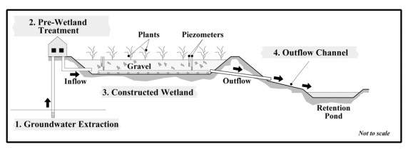
A pilot scale constructed wetland was built at the Strachan Gas Plant to evaluate its ability to treat dissolved phase hydrocarbons in groundwater. The overall objective was to assess the feasibility...
Resource
Authors
Curtis Brinker
Marc Symbaluk
J.G. Boorman
Pit reclaimed such that the end pit and inlet/outlet streams would sustain in perpetuity the full range of habitat and watershed features needed to support native Athabasca Rainbow and Bull Trout
Resource
Studies were continued in 1976 into the improvement of a five year old revegetated area on a tailings sand dike by the implementation of different fertilizer programs.
Resource
Authors
Terry Osko
Clayton Gillies
Matthew Pyper
Resource Date:
February
2018
This report compiles a toolbox of shared practices currently in use by COSIA companies, or which have been used but were found to be unsuccessful.
Resource
Authors
Alberta Centre for Reclamation and Restoration Ecology
Oil Sands Research and Information Network
One of the core mandates for the Oil Sands Research and Information Network (OSRIN) was to enhance access to oil sands environmental management information. With OSRIN’s mandate ending December 31...
Resource
Resource Date:
December
2020
A mesocosm study was undertaken to support the development of end pit lake technology. The mesocosms were exposed to OSPW (Oil Sands Process affected Water) and dFFT (densified Fluid Fine Tails).
Resource
Resource Date:
October
2018
This study utilized mesocosms to investigate the effects of oil sands process water (OSPW) and densified fluid fine tails (dFFT) on aquatic ecosystems to support development of end pit lake technology
Resource
Authors
Alberta Biodiversity Monitoring Institute
This report is part of a larger endeavor to develop a monitoring program capable of detecting changes in the biological diversity of Alberta’s forested region.
Resource
Long-term monitoring of some sites would ultimately be needed to show that recovering wellsites are on a trajectory that consistently leads to full recovery.
Resource
Soils sampled at sites 2.3 and 5.3 km south of the Great Canadian Oil Sands (GCOS) plant, Fort McMurray, respectively were found to differ statistically with reference to several macronutrients
Resource
Stem cuttings of balsam poplar and three poplar hybrids were directly planted onto reclamation material ontailings dyke slope. The overall rooting success was poor - direct planting is not recommended
Resource
Authors
Sandra Landsburg
Elizabeth Dwyer
Dissipation of bromacil in Humic Luvic Gleysols amended with cow manure was evaluated at two sites in northwestern Alberta from 1984 to 1987
Resource
348 benthic macroinvertebrate samples collected at 16 sites along 85 km of the Athabasca River between Fort McMurray and the Ells River. total of 27229 specimens belonging to 68 taxonomic groups
Resource
The trial was established on blended materials consisting of native sand, clayey overburden and peat. Nine native grasses and eight cultivated grass varieties were seeded in June of 1981.
Resource
Authors
Roger DeAbreu
Shane Patterson
Todd Shipman
Chris Powter
NRCan pilot science projects have proven that Earth Observation can provide relevant and valuable information to inform and enhance monitoring and support regulatory frameworks
Resource
There was only very limited evidence of biological responses to increased pollutant content in spite of significantly higher pollutant levels in tissues close to existing industrial developments.
Resource
Authors
M.D. Thompson
M.C. Wride
M.E. Kirby
Classification system devised for mapping vegetation and surficial geology from 1:60,000 scale false colour infrared photographs; 1:50 000 base maps plus a vegetation and a surficial geology overlay
Resource
Ground surveys of vegetation and surficial geology generally confirmed that the classification systems used in the mapping accurately described and defined the ecological habitat features
Resource
Authors
ERMP Project Advisory Group
Monitoring protocols for forested land wellsites to determine if a reclaimed site has returned to similar structure and function as found in a representative undisturbed reference area.
Resource
Authors
Alberta Biodiversity Monitoring Institute
Select appropriate vegetation, soil, and habitat indicators for a long-term reclamation monitoring program and provide sampling protocols for the selected indicators.