Land Management Search Results
Resource
A 22 slide presentation (exported as a pdf) providing an overview of effects of wind turbine development on Caribou.
Resource
Caribou herds in Jasper National Park are at risk. Without intervention, the only two herds remaining predominantly within Jasper will disappear. Parks Canada envisions a future with caribou herds...
Resource
Authors
Daniel Peters
Dillon Watt
Kevin Devito
Wendy Monk
Rajesh Shrestha
Donald Baird
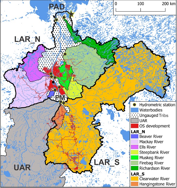
The goal of this study is to enhance the understanding of the regional role of the lower Athabasca Basin areas in overall runoff delivery to the downstream Peace-Athabasca Delta. The Cold-regions...
Resource
Organic constituents of wastewaters discharged from the GCOS plant and Syncrude Canada Ltd. lease No. 17 were characterized and compared to those occurring naturally in the Athabasca River
Resource
Authors
D.W. Mayhood
Linda Corkum
Baseline data available on the Muskeg River hydrology, benthic invertebrates, plankton and fish are generally useful, but additional information is desireable
Resource
Authors
D.W. Mayhood
Gerry Walder
Tom Dickson
R.B. Green
Dave Reid
R. Strushnoff
Studies intended to both monitor the effects of Alsands' muskeg drainage on aquatic habitats and terrestrial vegetation, and to form the basis of a long-term aquatic habitat monitoring program
Resource
The present volume evaluates the 1980 monitoring program, and makes suggestions for the conduct of future monitoring studies on the Muskeg River and elsewhere in the AOSERP area
Resource
Authors
C.R. Neill
B.J. Evans
A.W. Lipsett
Describe how water and sediment from the Athabasca River are distributed through the delta system and how they circulate and mix in Lake Athabasca and flow through to the Slave River (re contaminants)
Resource
Authors
Christopher Shank
Amy Nixon
This report provides a broad overview of how Alberta species are likely to be affected by climate change by the 2050s. Amphibians were consistently found to be the most vulnerable to climate change
Resource
Authors
Chris Powter
Brent Scorfield
Brent Lakeman
Shane Patterson
The development of integrated geomatics and remote sensing technologies for environmental management holds promise to meet economic diversification and effective environmental management.
Resource
Scenarios of expected concurrent flow along the Athabasca River are developed on the assumption that a 7Q10 event occurs at either Hinton, Whitecourt, Athabasca, or Fort McMurray
Resource
Authors
Tyler Rudolph
Pierre Drapeau
Louis Imbeau
Vincent Brodeur
Sonia Legare
Martin-Hugues St-Laurent
Resource Date:
January
2017
This resource is available on an external database and may require a paid subscription to access it. It is included on the CCLM to support our goal of capturing and sharing the breadth of all...
Resource
348 benthic macroinvertebrate samples collected at 16 sites along 85 km of the Athabasca River between Fort McMurray and the Ells River. total of 27229 specimens belonging to 68 taxonomic groups
Resource
Authors
Jason Clark
Ken Tape
Latha Baskaran
Clayton Elder
Charles Miller
Kimberley Miner
Jonathan O'Donnell
Benjamin Jones
Beaver engineering in the Arctic tundra induces hydrologic and geomorphic changes that are favorable to methane (CH 4) production. Beaver-mediated methane emissions are driven by inundation of...
Resource
Resource Date:
January
2016
This presentation provides an overview of the Ducks Unlimited Canada Enhanced Wetland Classification System, including current and potential uses for wetland conservation and management.
Project
The National Boreal Program of Ducks Unlimited Canada (DUC) has over 20 years of experience working with governments, Indigenous Peoples, and industry to develop comprehensive, science-based solutions...
Resource
Authors
Roger DeAbreu
Shane Patterson
Todd Shipman
Chris Powter
NRCan pilot science projects have proven that Earth Observation can provide relevant and valuable information to inform and enhance monitoring and support regulatory frameworks
Resource
Authors
Grant Hauer
Vic Adamowicz
Stan Boutin
This resource is available on an external database and may require a paid subscription to access it. It is included on the CCLM to support our goal of capturing and sharing the breadth of all...
Resource
Document presents the scientific and engineering expertise to guide all reclamation activities associated with end pit lake design and construction
Resource
Authors
J.P. Verschuren
L. Wojtiw
Point measurements of maximum depth showed that over 50% of the rainstorms occur in June and July, with only a small percentage in April (5.6) and September (10. 1).