Land Management Search Results
Resource
During 1977, the second year of a two-year study, the fish populations of the Athabasca Rive: were investigated in two general areas downstream of Fort McMurray from mid-April to early November
Resource
Authors
Robert Bott
Graham Chandler
Peter McKenzie-Brown
This book is written to help assess how effectively we have, or are, conserving our land base and providing the stewardship required to pass our legacy on to our progeny.
Resource
Authors
J.E. Hurley
J.A. Loo
P. DesRochers
H.E. Hirvonen
Highlights Invasive alien insect and disease species are of increasing concern to the health and economic viability of the forest ecosystems within the ecozone. Brown spruce longhorn beetle, an alien...
Resource
In 2017-2018, Canada's Oil Sands Innovation Alliance (COSIA) partnered with the Canadian Forest Service - Natural Resources Canada (NRCan) to develop a suite of extension products. These products...
Resource
Authors
Karla Buffalo
Carol Jones
John Errington
M.I.A. MacLean
In the future, Fort McKay will continue to strive for faster reclamation that will restore the land to pre-mining conditions and seek the complete elimination of fluid fine tailings stored in an EPL
Resource
Authors
Conservation and Utilization Committee
Alberta should regulate and control the Athabasca tar sands development for the socio-economic benefit of Albertans. Rate of development of 1 plant in every 4 years is consistent with present tecnolog
Resource
Authors
Oil Sands Research and Information Network
Current state of knowledge about shrubs and their use in oil sands reclamation noted a number of regulatory requirements and policies that support shrub use but a far larger list of impediments
Resource
The Galena Hill Ecosystem Map (GHEM) was initially developed to provide information about existing plant communities and their growth conditions to guide upcoming reclamation efforts at the historical...
Resource
Authors
Maurice Dusseault
Hal Soderberg
The post-reclamation subsidence of cast-back overburden is of interest to mining companies and regulatory agencies. Although subsidence may be of lesser concern than the prevention of soil degradation...
Resource
This glossary was prepared to provide those working in the field of reclamation in Alberta with a standardized set of definitions for reclamation terms.
Resource
Authors
Oil Sands Research and Information Network
Glossary provides understanding of the language and acronyms used in oil sands mining, processing and environmental management.
Resource
Authors
Scientific Enquiry Committee
Evaluate impact of the GCOS tailings discharges on the Athabasca River, and to provide recommendations on any necessary action to be taken by Alberta Environment and Great Canadian Oil Sands Limited.
Resource
Summary of the meteorological data collected by the meteorological tower network in the Gregoire Lake region of northeast Alberta during the spring and summer of 1979 to monitor impact of Amoco plant
Resource
Resource Date:
April
2017
This document is intended as a guide for reclamation of In Situ facilities in a peatland environment, specifically pad and road disturbances. Pilot studies conducted in Alberta were carried out by...
Resource
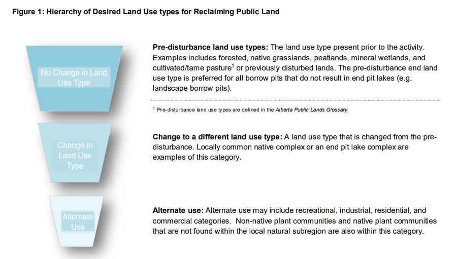
A primary goal of this Guideline is to emphasize the long-standing preference for reclaiming and restoring public lands to the pre-disturbance land use type.
Resource
Authors
Land Conservation and Reclamation Council
Regulatory expectations with respect to the detailed content of applications for approvals of surface disturbances and the reclamation of lands.
Resource
Resource Date:
December
2018
This practitioner guide provides a user-friendly overview of the interactions between boreal wetlands and forests and what these interactions mean for forest managers working in Canada’s boreal.
Resource
Resource Date:
December
2018
This technical report describes in detail the interactions between boreal wetlands and forests and how forest managers can use this information to help avoid or minimize adverse effects on wetlands.
Resource
Breeding bird studies using the mapping method were combined with intensive habitat quantification to determine the relative values to breeding avifauna of 21 habitat types
Resource
Authors
Stanley Van Dyke
Brian Reeves
In the course of the program, 7,608 shovel tests were excavated for the purpose of locating prehistoric sites in Syncrude's Bituminous Sands Lease No. 22.