Land Management Search Results
Resource
Authors
Kimberly Dawe
Erin Bayne
Stan Boutin
This resource is available on an external database and may require a paid subscription to access it. It is included on the CCLM to support our goal of capturing and sharing the breadth of all...
Resource
Authors
Tyler Muhly
Robert Serrouya
Eric Neilson
Haitao Li
Stan Boutin
Predictions demonstrate that maintaining permeability across In-situ oil sands development is more important than spacing between leases or including protected areas.
Resource
Authors
Ranjeet Nagare
Young-Jin Park
Rob Wirtz
Dallas Heisler
Glen Miller
The upland and wetlands substrate in reclaimed oil sands landforms will be constructed of post-mining materials with an objective of replicating the landscape and hydrology of the surrounding boreal...
Resource
Authors
Sini-Selina Salko
Jussi Juola
Iuliia Burdun
Harri Vasander
Miina Rautiainen
Boreal peatlands store ~25 % of global soil organic carbon and host many endangered species; however, they face degradation due to climate change and anthropogenic drainage. In boreal peatlands...
Resource
Authors
John Gibson
P. Eby
Jean Birks
Colin Twitchell
C. Gray
J. Kariyeva
Water sampling for stable isotopes ( 18O and 2H) was carried out during 2009–2019 across Alberta, Canada, as part of a survey targeting 1022 open water wetlands. The study presents the first site...
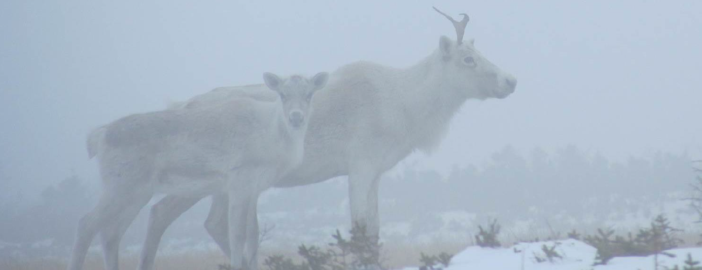
Resource
Authors
Dave Hervieux
Mark Hebblewhite
Dave Stepnisky
Michelle Bacon
Stan Boutin
Resource Date:
November
2014
Across Canada, woodland caribou ( Rangifer tarandus caribou (Gmelin, 1788)) populations are declining because of human-induced changes to food webs that are resulting in apparent competition-induced...
Resource
Authors
Boreal Avian Modelling Project
Bioclimatic niche models of current avian distribution and density for 80 boreal-breeding songbird species are mapped based on present counts and climate change models
Resource
Authors
Doug MacNearney
Karine Pigeon
Laura Finnegan
Resource Date:
October
2016
We used GPS telemetry location data from 63 adult caribou and 6 adult wolves to build spatially explicit resource selection function (RSF) rasters. These RSF rasters describe the within-home-range...
Resource
Welcome to MarshWatch! MarshWatch is a new pilot program focused on wetland birds and amphibians for beginners. Virtual webinars along with self-guided activities slowly build your identification...
Resource
Welcome to MarshWatch! MarshWatch is a new pilot program focused on wetland birds and amphibians for beginners. Virtual webinars along with self-guided activities slowly build your identification...
Resource
Welcome to MarshWatch! MarshWatch is a new pilot program focused on wetland birds and amphibians for beginners. Virtual webinars along with self-guided activities slowly build your identification...
Resource
Welcome to MarshWatch! MarshWatch is a new pilot program focused on wetland birds and amphibians for beginners. Virtual webinars along with self-guided activities slowly build your identification...
Resource
Comprehensive assessment of mixing characteristics of the Athabasca River below Fort McMurray under ice-covered flow conditions. Two tracer tests conducted and analysed using recent theoretical models
Resource
Authors
Masahito Ueyama
Sara Knox
Kyle Delwiche
Sheel Bansal
William Riley
Dennis Baldocchi
Takashi Hirano
Gavin McNicol
Karina Schafer
Lisamarie Windham-Myers
Benjamin Poulter
Robert Jackson
Kuang-Yu Chang
Jiquen Chen
Housen Chu
Ankur Desai
Sébastien Gogo
Hiroki Iwata
Minseok Kang
Ivan Mammarella
Matthias Peichl
Oliver Sonnentag
Eeva-Stiina Tuittila
Youngryel Ryu
Eugénie Euskirchen
Mathias Göckede
Adrien Jacotot
Mats Nilsson
Torsten Sachs
Resource Date:
January
2023
This resource is available on an external database and may require a paid subscription to access it. It is included on the CCLM to support our goal of capturing and sharing the breadth of all...
Resource
Potential for using satellite imagery to determine water quality parameters in the southwest end of Lake Athabasca and provide a mathematical model capable of simulating the circulation patterns
Resource
Authors
Anne McIntosh
Bonnie Drozdowski
Dani Degenhardt
Chris Powter
Christina Small
John Begg
Dan Farr
Arnold Janz
Randi Lupardus
Delinda Ryerson
Jim Schiek
We developed a scientifically robust and financially sustainable monitoring protocol to enable a consistent assessment of ecological recovery at reclaimed industrial wellsites in forested lands
Resource
Authors
Megan Hornseth
Karine Pigeon
Doug MacNearney
Terrence Larsen
Gordon Stenhouse
Jerome Cranston
Laura Finnegan
Natural regeneration of seismic lines, cleared for hydrocarbon exploration, is slow and often hindered by vegetation damage, soil compaction, and motorized human activity. There is an extensive...
Resource
Authors
Andrew Latham
Maria Latham
Mark Boyce
Stan Boutin
Resource Date:
December
2011
This resource is available on an external database and may require a paid subscription to access it. It is included on the CCLM to support our goal of capturing and sharing the breadth of all...
Resource
Authors
Cassidy van Rensen
Scott Nielsena
Barry White
Tim Vinge
Victor Lieffers
Mapping of oil reserves involves the use of seismic lines (linear disturbances) to determine both their location and extent. Conventional clearing techniques for seismic assessment have left a legacy...
Resource
Authors
Hedwig Lankau
Erin Bayne
Craig Machtans
The boreal forest of western Canada is being dissected by seismic lines used for oil and gas exploration. The vast amount of edge being created is leading to concerns that core habitat will be reduced...