Land Management Search Results
Resource
Resource Date:
August
2020
This document is part of the 360 tours project Toolkit developed by Canada's Oil Sands Innovation Alliance (COSIA) led by Cenovus Energy Inc., in collaboration with Natural Resources Canada. The...
Resource
Authors
Larry Turchenek
J.D. Lindsay
Recurring patterns of soils, landforms, and vegetation were delineated. The information was transferred first to 1:50,000 preliminary maps and then to eight 1:126,720 maps which accompany this report
Resource
Authors
Emily Ury
Puvaanah Arrumugam
Ellen Herbert
Pascal Badiou
Bryan Page
Nandita Basu
Resource Date:
April
2023
Wetland restoration is a popular nutrient management strategy for improving water quality in agricultural catchments. However, a wetland’s ability to retain phosphorus is highly variable and wetlands...
Resource
Authors
Suyuan Yang
Owen Sutton
Eric Kessel
Jonathan Price
At the Nikanotee Fen Watershed, a pioneering reclamation project in the Athabasca Oil Sands Region, elevated sodium (Na+) in the porewater of mine-waste materials has been shown to migrate to the fen...
Resource
Differences in microtopography were associated with differences in plant species richness and composition between OSE pads and the undisturbed sites.
Resource
Authors
Marie-Eve Gauthier
Line Rochefort
Leonie Nadeau
Sandrine Hugron
Bin Xu
Resource Date:
February
2017
This resource is available on an external database and may require a paid subscription to access it. It is included on the CCLM to support our goal of capturing and sharing the breadth of all...
Resource
Authors
Zhongzhi Chen
Brian Eaton
Jim Davies
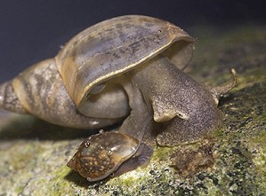
Overall, the literature supports the potential for aquatic snails to act as bioindicators of toxicity associated with oil sands process-affected-water exposure.
Resource
Authors
Sophie Wilkinson
Paul Moore
Dan Thompson
Mike Wotton
Stefan Hvenegaard
David Schroeder
James Waddington
Resource Date:
December
2018
This resource is available on an external database and may require a paid subscription to access it. It is included on the CCLM to support our goal of capturing and sharing the breadth of all...
Resource
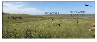
Study Focus: Six years of hydrochemical data (2013 – 2018) from the Sandhill Fen Watershed (SFW), a 52-ha upland-peatland catchment that was built upon highly saline soft tailings, were used to...
Resource
Resource Date:
August
2020
This document is part of the 360 tours project Toolkit developed by Canada's Oil Sands Innovation Alliance (COSIA) led by Cenovus Energy Inc., in collaboration with Natural Resources Canada. The...
Resource
Ground water conditions are frequently overlooked when placing surface materials in a mine reclamation scheme. The purpose of this paper is to outline the interaction between the surface materials and...
Resource
Authors
Dale Vitt
Melissa House
Lilyan Glaeser
Minerogenous peatlands that accumulate deep deposits of organic matter (fens) were an important part of the pre-disturbance landscape across Alberta’s oil sands mining area. Bryophytes occupy 80–100%...
Resource
Authors
Sophie Wilkinson
Gregory Verkaik
Paul Moore
Mike Waddington
Resource Date:
October
2019
This resource is available on an external database and may require a paid subscription to access it. It is included on the CCLM to support our goal of capturing and sharing the breadth of all...
Resource
Resource Date:
August
2020
This document is part of the 360 tours project Toolkit developed by Canada's Oil Sands Innovation Alliance (COSIA) led by Cenovus Energy Inc., in collaboration with Natural Resources Canada. The...
Resource
Authors
Angelo Filicetti
Scott Nielsen
This resource is available on an external database and may require a paid subscription to access it. It is included on the CCLM to support our goal of capturing and sharing the breadth of all...
Resource
Authors
Spencer Chad
Lee Barbour
Jeffrey McDonnell
John Gibson
Water samples were collected and analyzed regularly over an eight-year period to establish inventories of site-wide water isotope signatures including seasonal and interannual changes in the recycle...
Resource
Seismic lines are slow to recover naturally, and many seismic lines need to be restored to contribute towards caribou recovery. Caribou predators use seismic lines to travel throughout caribou ranges...
Resource
Field data on the abundance (or percent cover) of vascular plants, bryophytes, and soil mesofauna were obtained in the summer of 2008 and 2009 from nine produced water release sites in Alberta and...
Resource
Resource Date:
November
2020
The Vermillion River watershed region, found in central Alberta between Edmonton and Lloydminster, is home to residents and farmers who rely on the watershed for drinking water, agriculture, and...
Resource
The presentation describes the development and content of the draft Biodiversity Management Framework for the Lower Athabasca Region