Land Management Search Results
Resource
Study concentrated on the well-documented 1981 right-of-way, and compared it to the oldest trench, installed in 1957, and to the undisturbed adjacent mixed prairie
Resource
Authors
Majid Iravani
Monica Kohler
Shannon White
The results showed a pronounced variation in the historic supply of soil organic carbon and aboveground biomass in the watershed. Land management resulted in a diverse range of gains or losses.
Resource
Reclamation of the land surface is what makes non-renewable resource developments sustainable. We must continue to strive to improve our science so that we can prove to regulators and the public that
Resource
Authors
Cesar Estevo
Diana Stralberg
Scott Nielsen
Erin Bayne
Climate change refugia are areas that are relatively buffered from contemporary climate change and may be important safe havens for wildlife and plants under anthropogenic climate change. Topographic...
Resource
Recent decline of trembling aspen ( Populus tremuloides Michx.) near St. Walburg, Saskatchewan, prompted a study to document the onset and progress of aspen decline and to examine how past climate...
Resource
Objectives of the Twelve Mile Coulee Soil Research Project are to evaluate the impact of pipeline construction on Solonetzic soil quality and salt movement in the Brown soil zone
Resource
Authors
Randi Lupardus
Ermias Azeria
Kierann Santala
Isabelle Aubin
Anne McIntosh
Results suggest that even as practices and policies evolve, reclamation does not fully alleviate the legacy effects of industrial disturbance. Trait-based approaches can inform recovery assessment.
Resource
Authors
Amy Nixon
Christopher Shank
Dan Farr
The Biodiversity Management and Climate Change Adaptation project has produced a comprehensive, evidence-based, and original examination of the effects of climate change on Alberta’s biodiversity
Resource
This presentation describes a method of assessing cumulative effects, taking into account the many drivers or pressures on the landscape and their effects on watershed processes.
Resource
As a consequence of climate change, current landscape patterns are unlikely to persist in the future. The types of ecological changes expected to occur as the climate warms are described
Resource
Resource Date:
March
2013
This presentation describes how the Alberta oil and gas industry decided to go with a oil/gas spill cooperative rather than having individual company spill response units.
Resource
This presentation was a part of the Petroleum Technology Alliance of Canada, Hydraulic Fracturing in Western Canada: an Environmental Perspective Forum, in May of 2014.
Resource
This presentation provides an example oaf how Wet Areas Mapping and LiDAR can be used as a tool to monitor biodiversity.
Resource
Authors
Alvin First Rider
Justin Bruised head
Truman Big Swallow
Jamison Lucas Russell
Members of the Káínawa – or Blood Tribe – are applying training in western science, alongside their Indigenous Knowledge, to bring buffalo back to their historical habitat in southern Alberta, the...
Resource
Resource Date:
March
2012
Barry White discusses the ways LiDAR is being used by departments within the government of Alberta.
Resource
Bruce Peachey, president of New Paradigm Engineering Ltd, discusses the complexities of hydraulic fracturing in Alberta.
Resource
Susan Stuver, Research Scientist for Texas A&M Institute of Renewable Natural Resources, discusses the development of advanced analytical methods for open path systems
Resource
I will demonstrate how data from ABMI can be combined with designed research studies to answer questions at spatial scales and temporal extents that are not possible for a single researcher to achieve
Resource
Authors
Shannon White
Jim Herbers
Jasmine Janes
Sarah Depoe
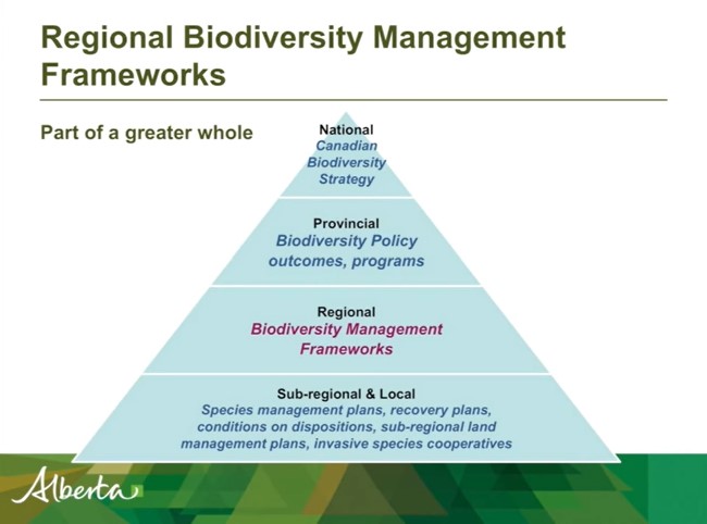
Shannon R. White is the Biodiversity Specialist for the Land-use Framework Regional Planning Branch for ESRD. She discusses Biodiversity Management Frameworks (BMFs), including indicators, triggers...
Resource
Resource Date:
March
2012
Jae Ogilvie presents on his group's research related to the use of Wet Areas Mapping data to predict the flow of contaminants from the Rainbow pipeline spill in northern Alberta in 2011.