Land Management Search Results
Resource
Authors
Oil Sands Research and Information Network
Current state of knowledge about shrubs and their use in oil sands reclamation noted a number of regulatory requirements and policies that support shrub use but a far larger list of impediments
Resource
The Galena Hill Ecosystem Map (GHEM) was initially developed to provide information about existing plant communities and their growth conditions to guide upcoming reclamation efforts at the historical...
Resource
Authors
Roberta Pedlar-Hobbs
Ian Ludgate
Kevin Ramsay
Developing and implementing a successful reclamation plan is dependent on a number of key factors, including defining clear objectives, assessing available options to meet those objectives, gathering...
Resource
Authors
NAIT Centre for Boreal Research
This flowchart outlines each step of the treatment process for forest land (upland) landscape as incorporated in the corresponding Decision Support Systems (DSS). View more tools by NAIT Centre for...
Resource
Authors
NAIT Centre for Boreal Research
This flowchart outlines each step of the treatment process for forest land (upland) soil as incorporated in the corresponding Decision Support Systems (DSS). View more tools by NAIT Centre for Boreal...
Resource
Authors
NAIT Centre for Boreal Research
This flowchart outlines each step of the treatment process for forest land (upland) vegetation as incorporated in the corresponding Decision Support Systems (DSS). View more tools by NAIT Centre for...
Resource
Restoration programs based on the use of natural processes can reduce the costs of restoration while providing self-sustaining restored ecosystems that re-integrate with the local recovery...
Resource
Authors
K. Stewart
E. Karppinen
S. Siciliano
Biochar is a soil amendment that results from heating various biological ingredients, such as wood, fish or animal bone under oxygen limited conditions and has proven to promote plant growth, as well...
Resource
The Oil Sands Research and Information Network (OSRIN) is a university-based, independent organization that compiles, interprets and analyses available knowledge about managing the environmental...
Resource
Model projections of tree regeneration under climate change on actual oil sands reclamation materials, and comprehensive model analysis of the risks to ecosystem productivity from climate change
Resource
Authors
David Polster
Chris Powter
Proceedings of the 2013 Northern Latitudes Mining Reclamation Workshop and 38 th Annual Meeting of the Canadian Land Reclamation Association. Whitehorse, Yukon, September 9 – 12, 2013
Resource
Authors
B. Ayres
Mike O'Kane
Lee Barber
D. Hiller
D. Helps
The Claude waste rock pile at Cluff Lake uranium mine in northern Saskatchewan's Athabasca basin contains ~7.2 million tonnes of waste rock, upon which an engineered enhanced store-and-release cover...
Resource
Vezza Mine, a former gold mine includes a three-compartment shaft with four underground levels down to a depth of 741 metres, This mine was never put in production since its construction around 1997...
Resource
Authors
Brian Eaton
Tyler Muhly
Jason Fisher
Shauna-Lee Chai
Reclaimed mine sites will consist of engineered landforms (including water bodies and waterways); the long-term hydrological and ecological function of those sites may be vulnerable to beaver activity
Resource
Authors
Anne Naeth
Sarah Wilkinson
Dean Mackenzie
Heather Archibald
Chris Powter
LFH salvaged with small amounts of upper horizon mineral soil for land reclamation has proven to be an important source of seeds and vegetative propagules for forest plant communities
Resource
Modelling results for the regional watersheds were encouraging and demonstrate that SWATBF has the potential to be utilized as a practical tool for conducting hydrologic assessments in the oil sands
Resource
During the Fall of 2006, the Ontario Ministry of Northern Development and Mines tendered a construction project to provide a soil cover over the North Impounded Tailings (NIT) area at the abandoned...
Resource
Authors
Mar Martinez
Gary Borstad
Leslie Brown
Kaan Ersahin
Michael Henley
Monitoring of reclaimed sites is a complex, interdisciplinary undertaking, especially in large, disturbed areas with difficult access. In that context, remote sensing is a unique and valuable tool...
Resource
Restoration of post mining disturbed sites within the boreal sub-alpine ecological communities of the Yukon has varied levels of success. Employing ecological succession principles to further the...
Resource
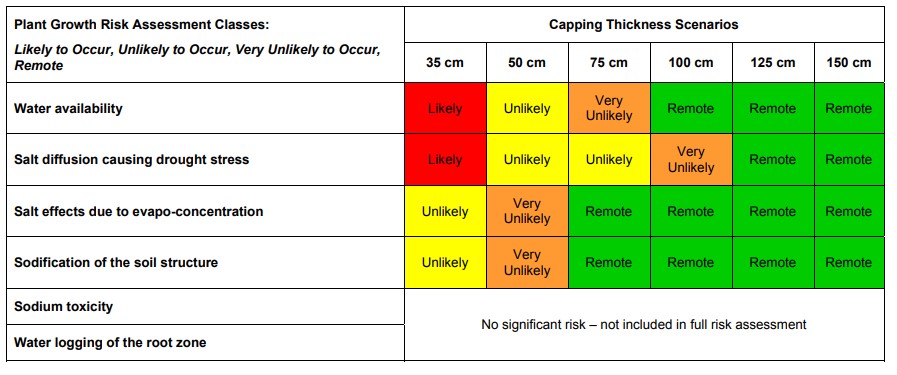
A thickness of 75 cm will provide adequate water supply to vegetation during droughts while also allowing for the release of water to the downstream reclaimed landscape.