Wetlands Knowledge Search Results
Resource
Protocols for sampling biotic and abiotic parameters in large lakes, large rivers, wetlands, and streams in Alberta is provided. Estimates of time costs are given.
Resource
Authors
Stan Aronoff
G.A. Ross
W.A. Ross
Figures and Tables associated with Volume 1
Resource
Authors
Manuel Helbig
Mike Waddington
Pavel Alekseychik
Brian Amiro
Mika Aurela
Alan Barr
Andrew Black
Sean Carey
Jiquan Chen
Jinshu Chi
Ankur Desai
Allison Dunn
Eugenie Euskirchen
Lawrence Flanagan
Thomas Friborg
Michelle Garneau
Achim Grelle
Silvie Harder
Michal Heliasz
Elyn Humphrey
Hiroki Ikawa
Pierre-Erik Isabelle
Hiroki Iwata
Rachhpal Jassal
Mika Korkiakoski
Juliya Kurbatova
Lars Kutzbach
Elena Lapshina
Anders Lindroth
Mikaell Lofvenius
Annalea Lohila
Ivan Mammarella
Philip Marsh
Paul Moore
Trofim Maximov
Daniel Nadeau
Erin Nicholls
Mats Nilsson
Takeshi Ohta
Matthias Peichl
Richard Petrone
Anatoly Prokushkin
William Quinton
Nigel Roulet
Benjamin Runkle
Oliver Sonnentag
Ian Strachan
Pierre Taillardat
Eeva-Stiina Tuittula
Juha-Pekka Tuovinen
Jessica Turner
Masahito Ueyama
Andrej Varlagin
Timo Vesala
Martin Wilmking
Vyacheslav Zyrianov
Resource Date:
October
2020
Peatlands and forests cover large areas of the boreal biome and are critical for global climate regulation. They also regulate regional climate through heat and water vapour exchange with the...
Resource
Northern peatlands are significant contributors to global biogeochemical cycles. In Canada alone, peatlands cover over a tenth of the land surface and store over half of the country’s terrestrial...
Resource
Authors
B.L. Barge
R.G. Humphries
S.L. Olson
The feasibility of a weather radar to map precipitation in the Alberta Oil Sands Environmental Research Program (AOSERP) study area near Fort McMurray, Alberta was investigated
Resource
Authors
Dale Vitt
Melissa House
Lilyan Glaeser
Minerogenous peatlands that accumulate deep deposits of organic matter (fens) were an important part of the pre-disturbance landscape across Alberta’s oil sands mining area. Bryophytes occupy 80–100%...
Resource
Authors
Alberta Biodiversity Monitoring Institute
As of 2010, human footprint in the Active In-situ Region was 7.7%, whereas it was 20.8% in the Mineable Region. Total human footprint in all Woodland Caribou ranges increased between 2007 and 2010
Resource
Authors
Alberta Biodiversity Monitoring Institute
As of 2012, the total human footprint across the OSR was 13.8%. Energy footprint covered 2.2% of the OSR. The total human footprint in the OSR increased from 11.3% to 13.8% between 1999 and 2012.
Resource
Authors
Alberta Biodiversity Monitoring Institute
This report presents data on several indicators of environmental health for the Kakwa River Project area where ARC Resources operates in northwestern Alberta. The Kakwa River Project area covers...
Resource
Oil and gas activities in Alberta require disturbing forested lands, among other ecosystems, in order to extract resources. Due to the number of oil and gas sites requiring reclamation, monitoring can...
Resource
Authors
Amy Nixon
Christopher Shank
Dan Farr
The Biodiversity Management and Climate Change Adaptation project has produced a comprehensive, evidence-based, and original examination of the effects of climate change on Alberta’s biodiversity
Resource
Understanding how populations are structured and how they use natural and anthropogenic spaces is essential for effective wildlife management. A total of 510 barren-ground ( Rangifer tarandus...
Resource
Authors
Jennifer Hird
Alessandro Montaghi
Gregory McDermid
Jahan Kariyeva
Brian Moorman
Scott Nielsen
Anne McIntosh
Good statistical agreement between key structural vegetation parameters, such as mean and maximum vegetation height, with PPC metrics successfully predicting most height and tree-diameter metrics.
Resource
Authors
William Wadsworth
Ave Dersch
Robin Woywitka
Kisha Supernant
The Athabasca Oil Sands (AOS) region of Alberta has one of the densest accumulations of known archaeological sites, and possibly the most archaeological sites at risk, in the country. Expanding...
Resource
Seismic lines are slow to recover naturally, and many seismic lines need to be restored to contribute towards caribou recovery. Caribou predators use seismic lines to travel throughout caribou ranges...
Resource
Jim Schieck, research scientist at Alberta Innovates – Technology Futures, discusses how cumulative effects are currently being assessed in Alberta. He talks about the pilot study of how to use...
Resource
Video tutorial that lays out the field sampling process for reclaimed wetland assessment from start to finish in easy-to-follow steps and visually clarifies how protocols should be enacted
Resource
ABMI is working with the Government of Alberta to develop new methods to estimate caribou numbers, a species that is notoriously hard to count because of their rarity and association with dense forest
Resource
Authors
Gabrielle Coulombe
Libby Ehlers
Jim Herriges
Torsten Bentzen
Mike Suitor
Kyle Joly
Mark Hebblewhite
A 1:45 video compilation of video taken from collared caribou in the fortymile herd showing a variety of behaviors including foraging, birthing, and nursing.
Resource
Authors
Shannon White
Jim Herbers
Jasmine Janes
Sarah Depoe
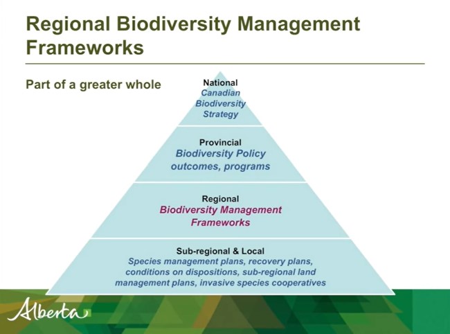
Shannon R. White is the Biodiversity Specialist for the Land-use Framework Regional Planning Branch for ESRD. She discusses Biodiversity Management Frameworks (BMFs), including indicators, triggers...