Wetlands Knowledge Search Results
Resource
Authors
Megan Hornseth
Karine Pigeon
Doug MacNearney
Terrence Larsen
Gordon Stenhouse
Jerome Cranston
Laura Finnegan
Natural regeneration of seismic lines, cleared for hydrocarbon exploration, is slow and often hindered by vegetation damage, soil compaction, and motorized human activity. There is an extensive...
Resource
Authors
Andrew Latham
Maria Latham
Mark Boyce
Stan Boutin
Resource Date:
December
2011
This resource is available on an external database and may require a paid subscription to access it. It is included on the CCLM to support our goal of capturing and sharing the breadth of all...
Resource
Authors
National Tree Seed Centre
This webinar presented by the National Tree Seed Centre focuses on tree and shrub species that produce seed in the autumn and how to predict if they will produce a good seed crop. Species discussed...
Resource
Authors
National Tree Seed Centre
This webinar presented by the National Tree Seed Centre explains how to collect seeds from berry producing plants species. NTSC staff demonstrate protocols for handling and processing berries to...
Resource
Authors
National Tree Seed Centre
Resource Date:
April
2022
This webinar presented by the National Tree Seed Centre focuses on tree and shrub species at risk and how to properly and effectively collect and store their seeds for maximum reforestation potential...
Resource
Authors
National Tree Seed Centre
This webinar presented by the National Tree Seed Centre teaches the skills and practices needed for collecting seeds from tree species which produce seeds in the spring. NTSC staff discuss maples...
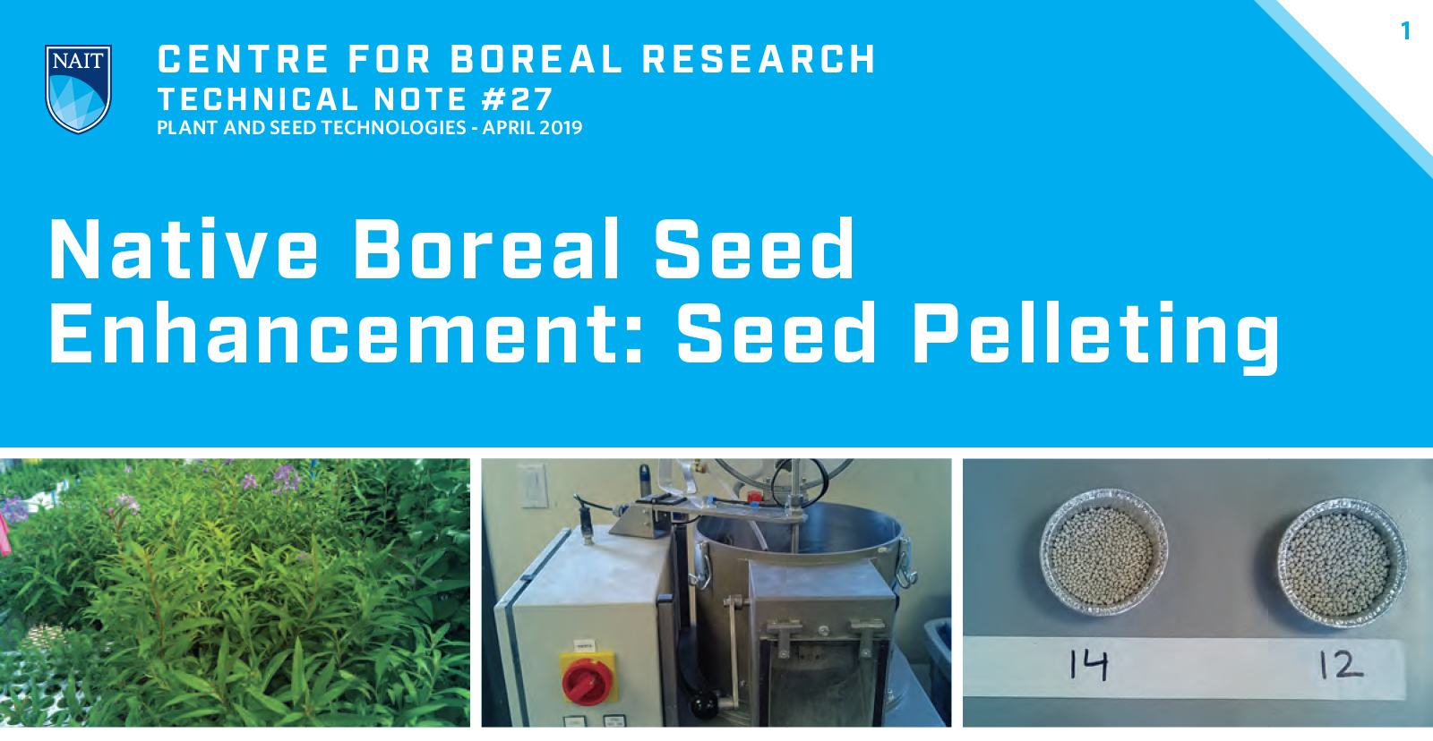
Resource
Authors
Ryan O’Neill
Jean-Marie Sobze
Catherine Brown
Improving seed emergence and survival is one of the largest potential benefits for native boreal seed enhancement. Seed pelleting can increase seed size by multiple orders of magnitude, resulting in...
Resource
Authors
Cassidy van Rensen
Scott Nielsena
Barry White
Tim Vinge
Victor Lieffers
Mapping of oil reserves involves the use of seismic lines (linear disturbances) to determine both their location and extent. Conventional clearing techniques for seismic assessment have left a legacy...
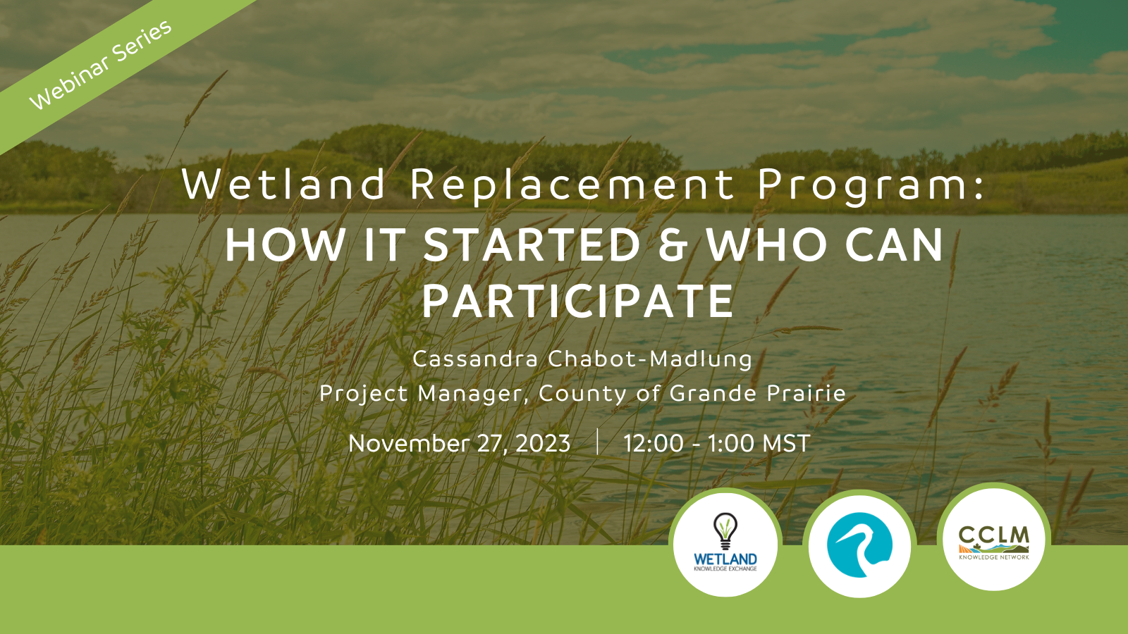
Resource
Authors
Wetland Knowledge Exchange
Resource Date:
November
2023
Cassandra Chabot-Madlung, County of Grande Prairie presents - Wetland Replacement Program: How it Started & Who Can Participate This is a Municipal viewpoint of Alberta Environment and Protected Areas...
Resource
Authors
Richard Johnson
P. Bork
E.A.D. Allen
W.H. James
L. Koverny
The experiments detailed in this report show that it was possible to increase the solids content of sludge to 50% solids by adding three parts sand (tailings sand) to one part sludge.
Resource
Authors
Hedwig Lankau
Erin Bayne
Craig Machtans
The boreal forest of western Canada is being dissected by seismic lines used for oil and gas exploration. The vast amount of edge being created is leading to concerns that core habitat will be reduced...
Resource
Authors
G.R. Hillman
J.D. Johnson
S.K. Takyi
Three experimental forest drainage sites were established in Alberta’s boreal forest to determine the effects of lowered water tables on soils, local hydrology, ground vegetation composition and tree...
Resource
Authors
Ting Sun
Brian Branfireun
Abstract Plant foliage plays an essential role in accumulating mercury (Hg) from the atmosphere and transferring it to soils in terrestrial ecosystems, and many studies have focused on forested...
Resource
Authors
Canadian Conservation and Land Management Network
This infographic synthesizes knowledge from a variety of resources on the Canadian and Conservation Land Management (CCLM) Knowledge Portal. It highlights some important considerations for managers...
Resource
Mapping of oil reserves involves the use of seismic lines (linear disturbances) to determine size of reserves. These linear disturbances fragment forests and in many cases fail to regenerate trees...
Resource
Modelling results for the regional watersheds were encouraging and demonstrate that SWATBF has the potential to be utilized as a practical tool for conducting hydrologic assessments in the oil sands
Resource
Authors
Chantel Markle
Paul Moore
Mike Waddington
Identifying ecosystems resilient to climate and land-use changes is recognized as essential for conservation strategies. However, wetland ecosystems may respond differently to stressors depending on...
Resource
Authors
Alberta Biodiversity Monitoring Institute
Boreal caribou populations are declining across Alberta and much of their Canadian range. Key factors causing this decline include a warming climate along with habitat change from industrial...
Resource
Authors
Alberta Biodiversity Monitoring Institute
Seismic lines and other linear features created by humans are thought to negatively impact woodland caribou. It is estimated that there are c. 100,000 km of conventional seismic lines in caribou...
Resource
Authors
Alberta Biodiversity Monitoring Institute
Resource Date:
January
2020
Linear features, including seismic lines, pipelines, transmission lines, roads, railways, and trails are pervasive in Alberta’s boreal forest and have been implicated as a primary factor leading to...