Wetlands Knowledge Search Results
Resource
Authors
Meike Lemmer
Bin Xu
Maria Strack
Linne Rochefort
Resource Date:
April
2022
This resource is available on an external database and may require a paid subscription to access it. It is included on the CCLM to support our goal of capturing and sharing the breadth of all...
Resource
Authors
Chris Powter
Neil Chymko
Gordon Dinwoodie
Darlene Howat
Arnold Janz
Ryan Puhlmann
Tanya Richens
Don Watson
Heather SInton
Kevin Ball
Andy Etmanski
Bruce Patterson
Larry Brocke
Ralph Dyer
Alberta’s industrial land conservation and reclamation program developed over 48 yr from an initial focus on surface debris removal and safety to increasing emphasis on returning ecological function
Resource
Authors
Kimberley Murray
Melanie Bird
Maria Strack
Michael Cody
Bin Xu
Resource Date:
April
2021
This article outlines the results of monitoring two restored oil sands exploration sites, and discusses the effectiveness of treatments on tree recovery and greenhouse gas emissions.
Resource
Authors
Bin Xu
Line Rochefort
Melanie Bird
Bhupesh Khadka
Maria Strack
The prompt introduction and establishment of peatland donor species through moss layer transfer technique was crucial to the overall re-establishment of peatland vegetation.
Resource
Authors
Anna Dabros
Kellina Higgins
Jaime Pinzon
This resource is available on an external database and may require a paid subscription to access it. It is included on the CCLM to support our goal of capturing and sharing the breadth of all...
Resource
Authors
Laura Chasmer
Edberto Moura Lima
Craig Mahoney
Chris Hopkinson
Joshua Montgomery
Danielle Cobbaert
Resource Date:
August
2021
Bi-temporal LiDAR data used to identify correspondence between density of anthropogenic disturbances, wetland shape complexity and changes in vegetation height within >1800 wetlands near Fort McKay
Resource
Authors
Caitlyn Lyons
Brain Branfireun
Jim McLaughlin
Zoë Lindo
This resource is available on an external database and may require a paid subscription to access it. It is included on the CCLM to support our goal of capturing and sharing the breadth of all...
Resource
Authors
Suyuan Yang
Owen Sutton
Eric Kessel
Jonathan Price
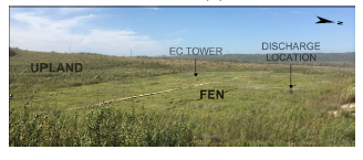
At the Nikanotee Fen Watershed, a pioneering reclamation project in the Athabasca Oil Sands Region, elevated sodium (Na+) in the porewater of mine-waste materials has been shown to migrate to the fen...
Resource
Authors
Meagan Wood
Merrin Macrae
Maria Strack
Jonathan Price
Terry Osko
Richard Petrone
Wetlands are found extensively throughout the Western Boreal Plain, a region under pressure because of disturbance by the oil and gas industries. To understand how wetland systems may respond to...
Resource
Authors
Caitlin Willier
Jacqueline Dennett
Kevin Devito
Christopher Bater
Scott Nielsen
This resource is available on an external database and may require a paid subscription to access it. It is included on the CCLM to support our goal of capturing and sharing the breadth of all...
Resource
Authors
Tania Garcia Bravo
Line Rochefort
Maria Strack
Resource Date:
January
2018
This study determined the effect of a 7-year-old black spruce (Picea mariana) plantation on the carbon balance of a cutover peatland.
Resource
Authors
Angeline Van Dongen
Caren Jones
Amanda Schoonmaker
Jill Harvey
Dani Degenhardt
Resource Date:
November
2022
Alberta’s forests are becoming increasingly disturbed and fragmented by the cumulative effects of anthropogenic distur�bances exacerbated by the enduring footprint of seismic lines on the landscape...
Resource
Authors
Guillermo Castilla
Ronald Hall
Rob Skakun
Michelle Filiatrault
André Beaudoin
Michael Gartrell
Lisa Smith
Kathleen Groenewegen
Chris Hopkinson
Jurjen van der Sluijs
Resource Date:
February
2022
Wall-to-wall 30 m raster maps of broad forest type, stand height, crown closure, stand volume, total volume, aboveground biomass, and stand age were created for a ~400,000 km2 area, validated with independent data, and generalized into a polygon GIS layer resembling a traditional FI map. The MVI project showed that a reasonably accurate FI map for large, remote, predominantly non-inventoried boreal regions can be obtained at a low cost by combining limited field data with remote sensing data from multiple sources.
Resource
Authors
Jean-Marie Sobze
Lakshman Galagedara
Mumtaz Cheema
Raymond Thomas
Sahari Inoue
Boreal forests across Canada and other geographic areas globally have vast networks or densities of seismic lines, pipelines, access roads, utility corridors, and multipurpose trails collectively termed “linear disturbances” or “linear features.”
Resource
Authors
Kristine Haynes
Jessica Smart
Brenden Disher
Olivia Carpino
William Quinton
Resource Date:
December
2020
This resource is available on an external database and may require a paid subscription to access it. It is included on the CCLM to support our goal of capturing and sharing the breadth of all...
Resource
Authors
Dale Vitt
Melissa House
Lilyan Glaeser
Minerogenous peatlands that accumulate deep deposits of organic matter (fens) were an important part of the pre-disturbance landscape across Alberta’s oil sands mining area. Bryophytes occupy 80–100%...
Resource
Authors
Paul Pickell
David Andison
Nicholas Coops
Sarah Gergel
Peter Marshall
Resource development can have significant consequences for the distribution of vegetation cover and for species persistence. Modelling changes to anthropogenic disturbance regimes over time can...
Resource
Authors
Cesar Estevo
Diana Stralberg
Scott Nielsen
Erin Bayne
Climate change refugia are areas that are relatively buffered from contemporary climate change and may be important safe havens for wildlife and plants under anthropogenic climate change. Topographic...
Resource
Authors
Katherine Dearborn
Jennifer Baltzer
Resource Date:
March
2021
This resource is available on an external database and may require a paid subscription to access it. It is included on the CCLM to support our goal of capturing and sharing the breadth of all...
Resource
Authors
Jennifer Hird
Alessandro Montaghi
Gregory McDermid
Jahan Kariyeva
Brian Moorman
Scott Nielsen
Anne McIntosh
Good statistical agreement between key structural vegetation parameters, such as mean and maximum vegetation height, with PPC metrics successfully predicting most height and tree-diameter metrics.