Wetlands Knowledge Search Results
Resource
Authors
Humaira Enayetullah
Laura Chasmer
Chris Hopkinson
Daniel Thompson
Danielle Cobbaert
Seismic lines are the dominant anthropogenic disturbance in the boreal forest of the Canadian province of Alberta, fragmenting over 1900 km 2 of peatland areas and accounting for more than 80% of all...
Resource
Authors
Chris Stockdale
Quinn Barber
Amit Saxena
Marc-Andre Parisien
Resource Date:
March
2019
We undertook a wildfire risk assessment across the Cold Lake caribou range where we used the Burn-P3 model to determine: a) burn probability; b) wildfire risk to restored seismic line areas; and c) the effectiveness of mitigation measures. The burn probability of the landscape was highly heterogeneous, and recent large burns and some waterbodies provided “shields” that reduced burn probability on their leeward sides.
Resource
Literature review provides an understanding of ecological resilience as a concept to promote successful land reclamation in Alberta’s mineable oil sands region
Resource
Authors
Kevin Renkema
Dean MacKenzie
Natalie Shelby‐James
Bin Xu
Chris Powter
The pilot study validated the research questions, sampling design, measurement and data analysis methods developed for a large‐scale study, with some minor amendments.
Resource
Authors
Melanie Dickie
Robert Serrouya
Scott McNay
Stan Boutin
Predation by grey wolves Canis lupus has been identified as an important cause of boreal woodland caribou Rangifer tarandus caribou mortality, and it has been hypothesized that wolf use of human...
Resource
Resource Date:
August
2020
This document is part of the 360 tours project Toolkit developed by Canada's Oil Sands Innovation Alliance (COSIA) led by Cenovus Energy Inc., in collaboration with Natural Resources Canada. The...
Resource
Authors
Robert Bott
Graham Chandler
Peter McKenzie-Brown
This book is written to help assess how effectively we have, or are, conserving our land base and providing the stewardship required to pass our legacy on to our progeny.
Resource
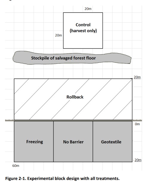
I I tested forest floor protection techniques in the construction and reclamation of temporary drilling pads to restore native boreal canopy and understory cover. By covering and delineating the...
Resource
Authors
E.A. Allen
R.W. Garbutt
H.E. Hirvonen
H. Pinnell
Highlights In 2003, mountain pine beetle infested an area of over 4 million ha within British Columbia. Almost all of this infestation occurred within the pine forests of the Montane Cordillera...
Resource
In 2017-2018, Canada's Oil Sands Innovation Alliance (COSIA) partnered with the Canadian Forest Service - Natural Resources Canada (NRCan) to develop a suite of extension products. These products...
Resource
Authors
Jian Zhang
Scott Nielsen
Jessica Stolar
Youhua Chen
Wilfried Thuiller
We found that 368 species (24%) may lose on average > 80% of their current suitable climates (habitats), while 539 species (35%) were projected to more than double their current suitable range
Resource
Authors
Oil Sands Research and Information Network
Glossary provides understanding of the language and acronyms used in oil sands mining, processing and environmental management.
Resource
Authors
Katherine Standen
Jennifer Baltzer
Questions Rapid climate change in northern latitudes is expected to influence plant functional traits of the whole community (community-level traits) through species compositional changes and/or trait...
Resource
Authors
Tracy McKay
Gordon Stenhouse
In 2010 and 2011, the Foothills Research Institute Grizzly Bear Program (FRIGBP) received funding from the Alberta Upstream Petroleum Research Fund (AUPRF) and other program partners to investigate...
Resource
Authors
Tracy McKay
Karen Graham
Gordon Stenhouse
This report includes results from two years of research investigating grizzly bear response to oil and gas pipelines in the Kakwa region of west-central Alberta. We investigated grizzly bear habitat...
Resource
Authors
Jean Birks
John Manchuk
Yi Yi
Cynthia McClain
Michael Moncur
John Gibson
Clayton Deutsch
Emily Taylor
Guy Bayegnak
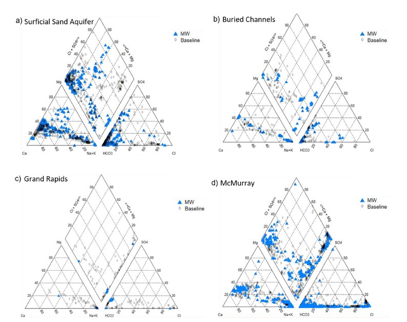
Groundwater quality data for the AOSR are compiled and interpreted to provide information on regional water quality to inform groundwater monitoring and land use planning. A database of 546 water...
Resource
Authors
Jean Birks
John Manchuk
Yi Yi
Cynthia McClain
Michael Moncur
John Gibson
Clayton Deutsch
Emily Taylor
Guy Bayegnak
Groundwater quality data for the AOSR are compiled and interpreted to provide information on regional water quality to inform groundwater monitoring and land use planning. A database of 546 water...
Resource
Authors
Heather Tokay
Dean MacKenzie
Chris Powter
Bonnie Drozdowski
Kevin Renkema
This document provides five case studies to show how the Guide to Variance Justifications for Reclamation Certification would be applied to real‐world examples of reclamation certificate applications
Resource
Resource Date:
April
2017
The Guide for Reclaiming Aggregate and Borrow Excavations to Water Bodies (The Guide) was prepared for Canada’s Oil Sands Innovation Alliance (COSIA) and is a is a presentation of current knowledge...
Resource
Resource Date:
April
2017
This document is intended as a guide for reclamation of In Situ facilities in a peatland environment, specifically pad and road disturbances. Pilot studies conducted in Alberta were carried out by...