Wetlands Knowledge Search Results
Resource
Authors
Jessica Hudson
Çağdaş Kera Yücel
Amanda Schoonmaker
Jean-Marie Sobze
This resource is available on an external database and may require a paid subscription to access it. It is included on the CCLM to support our goal of capturing and sharing the breadth of all...
Resource
Authors
Xuehui Sun
Wenqing Zhang
Robert Vassov
Ira Sherr
Ning Du
Janusz Zwiazek
The land disturbed by open-pit oil sands mining must be restored to support the survival and growth of native boreal plants. Because tailings sand and sodic shale overburden are commonly used as an...
Resource
Authors
Ashlee Dawn Mombourquette
Wetlands comprise 65% of the Athabasca Oil Sands Region (AOSR) surface mineable area and thus support diverse flora (approximately 400 species in Alberta). Due to increased anthropogenic land...
Resource
Authors
Mohammed Henneb
Osvaldo Valeria
Nelson Thiffault
Nicole Fenton
Yves Bergeron
Resource Date:
August
2019
Low productivity caused by paludification in some parts of the closed black spruce (Picea mariana (Mill.) B.S.P) dominated boreal forest threatens the provision of ecosystem services, including wood...
Resource
Authors
Eleanor Stern
Federico Riva
Scott Nielsen
Resource Date:
August
2018
Forest fragmentation threatens forest biodiversity and ecosystem function. One of the concerns relates to increases in edge effects, which among other things affects the forest microclimate that...
Resource
Authors
Lisa Lumley
Ermias Azeria
Victoria Giacobbo
Tyler Cobb
Soil contains a diverse fauna and microflora that are vital for maintaining healthy soils and their various ecosystem services. Oribatid mites are typically highly abundant arthropods in the soil and...
Resource
To determine the effects of population, environment and their interaction on the variability of seed germination, seeds of 27 random native Alberta populations of Saskatoon berry ( Amelanchier...
Resource
Authors
Angelo Filicetti
Scott Nielsen
Energy exploration has led to fragmentation of habitats worldwide. In boreal forests of Alberta, Canada narrow clear-cut linear disturbances (3–14 m wide) called seismic lines are often the largest...
Resource
Authors
Olena Volik
Richard Petrone
Meaghan Quanz
Merrin Macrae
Rebecca Rooney
Jonathan Price
Resource Date:
December
2019
This resource is available on an external database and may require a paid subscription to access it. It is included on the CCLM to support our goal of capturing and sharing the breadth of all...
Resource
Authors
Oona Könönen
Olli Karjalainen
Juha Aalto
Miska Luoto
Jan Hjort
The anthropogenic climate change threatens northern permafrost environments. This compromises the existence of permafrost landforms, such as palsas and peat plateaus, which have been assessed to be...
Resource
Authors
Ruth Errington
Ellen Macdonald
Natalka Melnycky
Jagtar Bhatti
Climate warming in the North could lead to lichen decline within critical woodland caribou habitat. We used repeat measurements of sixty-nine plots over ten years (2007–2008 and 2017–2018) to assess...
Resource
Authors
Matthew Elmes
Eric Kessel
Corey Wells
George Sutherland
Jonathan Price
Merrin Macrae
Richard Petrone
Resource Date:
January
2021
Removal and reclamation should be considered as a worthwhile venture for roads that extend through fens and are no longer in use.
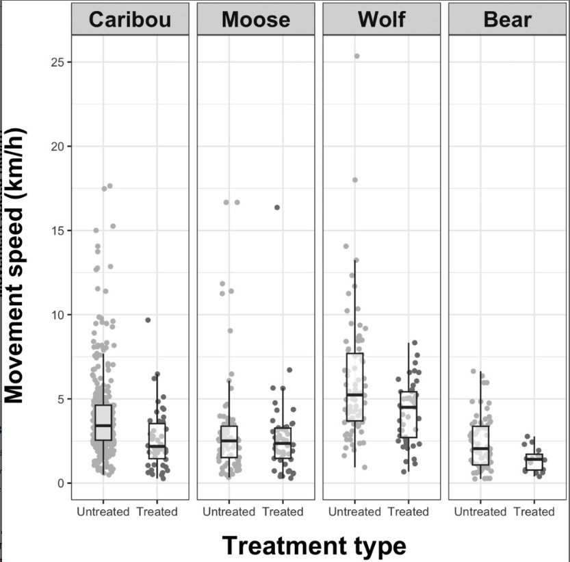
Resource
Authors
Melanie Dickie
Geoff Sherman
Glenn Sutherland
Robert McNay
Michael Cody
Fragmentation of the boreal forest by linear features, including seismic lines, has destabilized predator–prey dynamics, resulting in the decline of woodland caribou (Rangifer tarandus caribou)...
Resource
Authors
Humaira Enayetullah
Laura Chasmer
Chris Hopkinson
Daniel Thompson
Danielle Cobbaert
Seismic lines are the dominant anthropogenic disturbance in the boreal forest of the Canadian province of Alberta, fragmenting over 1900 km 2 of peatland areas and accounting for more than 80% of all...
Resource
Authors
Chris Stockdale
Quinn Barber
Amit Saxena
Marc-Andre Parisien
Resource Date:
March
2019
We undertook a wildfire risk assessment across the Cold Lake caribou range where we used the Burn-P3 model to determine: a) burn probability; b) wildfire risk to restored seismic line areas; and c) the effectiveness of mitigation measures. The burn probability of the landscape was highly heterogeneous, and recent large burns and some waterbodies provided “shields” that reduced burn probability on their leeward sides.
Resource
Authors
Mathilde Lapointe St-Pierre
Julie Labbé
Marcel Darveau
Louis Imbeau
Marc Mazerolle
This resource is available on an external database and may require a paid subscription to access it. It is included on the CCLM to support our goal of capturing and sharing the breadth of all...
Resource
Authors
Tyler Flockhart
Greg Mitchell
Richard Krikun
Erin Bayne
Successful conservation of migratory birds demands we understand how habitat factors on the breeding grounds influences breeding success. Multiple factors are known to directly influence breeding...
Resource
Authors
Melanie Dickie
Robert Serrouya
Scott McNay
Stan Boutin
Predation by grey wolves Canis lupus has been identified as an important cause of boreal woodland caribou Rangifer tarandus caribou mortality, and it has been hypothesized that wolf use of human...
Resource
Authors
Ann Smreciu
Kimberly Gould
This study evaluated the effect of sowing season (spring versus fall) and propagule type (clean seeds versus whole fruit) on emergence of 41 species on oil sands mine reclamation sites.
Resource
Authors
K.J. Hokanson
E.S. Peterson
Kevin Devito
Carl Mendoza
Resource Date:
February
2020
It is common to conceptualize the water table as a subdued replica of surface topography, where groundwater recharges at, and flowsfrom, topographic highs and flows to, and discharges at, topographic...